Vegetation zones — also known as biomes or plant communities — are the great regional assemblages of plant life that cover the Earth’s land surface in broad, recognizable belts and patches, each shaped by the interplay of climate, soils, topography, and evolutionary history into a distinctive community of species adapted to the conditions of that particular environment. From the dark, dripping canopy of equatorial rainforests to the wind-scoured cushion plants of polar tundra, from the fire-adapted grasslands of tropical savannas to the salt-tolerant communities of coastal marshes, vegetation zones represent the visible expression of the Earth’s climatic diversity written in living green across the planetary surface.
Vegetation covers approximately 71 percent of the Earth’s land surface — roughly 105 million square kilometers — with the remaining area occupied by ice sheets, bare rock, urban development, and hyper-arid deserts too dry to support any plant life. This vegetated surface contains an estimated 390,000 known species of plants, ranging from microscopic aquatic algae to the giant sequoias of California — the largest living organisms on Earth by volume, reaching heights of over 94 meters and trunk diameters of more than 9 meters. Plants collectively produce approximately 560 billion tons of oxygen per year through photosynthesis, maintain the atmospheric composition that makes animal life possible, cycle enormous quantities of water, carbon, and nutrients through ecosystems, and build the soils on which all terrestrial life ultimately depends.
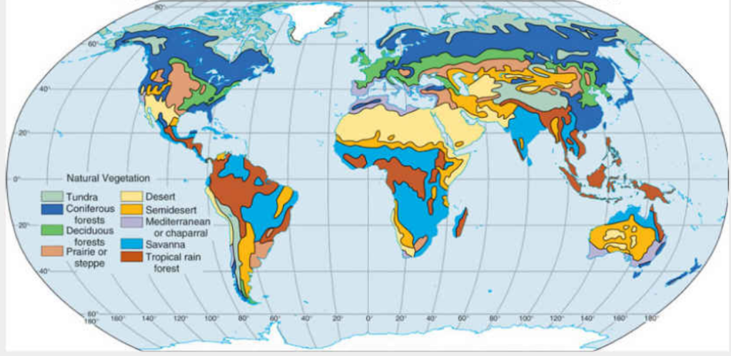
The distribution of vegetation zones across the Earth’s surface follows broad patterns determined primarily by latitude, temperature, and precipitation — the fundamental climatic variables that determine which plants can survive and thrive in any given location. These patterns were first systematically described by the German naturalist Alexander von Humboldt in the early 19th century, who recognized that similar vegetation types appear at equivalent climates regardless of their geographical separation. A tropical rainforest in the Amazon, the Congo Basin, and Borneo may contain entirely different species, but their structural and functional similarity reflects the universal response of plant life to warm, wet, aseasonal conditions. Understanding vegetation zones is therefore not merely a matter of botanical classification but a window into the fundamental ecological architecture of our living planet.
Tropical Rainforests
Tropical rainforests are the most biologically diverse terrestrial ecosystems on Earth, found within approximately 10 degrees of the equator where temperatures remain consistently high — averaging 25 to 28°C year-round — and rainfall is abundant and relatively evenly distributed, typically exceeding 2,000 millimeters per year with no prolonged dry season.
They cover approximately 6 percent of the Earth’s land surface — about 6 million square kilometers — yet harbor an estimated 50 percent of all terrestrial species. The Amazon rainforest alone covers approximately 5.5 million square kilometers and contains an estimated 10 percent of all species on Earth, including approximately 40,000 plant species, 1,300 bird species, and 3,000 freshwater fish species.
The structure of tropical rainforests is extraordinarily complex, with a layered canopy architecture reaching heights of 30 to 40 meters punctuated by emergent trees exceeding 60 meters, beneath which grow subcanopy trees, shrubs, and a ground layer adapted to deep shade. This vertical complexity multiplies the available habitats and drives the extraordinary species diversity that makes tropical rainforests the most species-rich environments on land.
Tropical rainforests are being lost at an alarming rate — approximately 4.7 million hectares of primary tropical forest are destroyed annually, with the Amazon, the Congo Basin, and the forests of Southeast Asia experiencing the most severe losses. Since 1970, approximately 18 percent of the Amazon rainforest has been destroyed, and scientists warn that deforestation approaching 20 to 25 percent could trigger a tipping point beyond which large portions of the remaining forest convert irreversibly to savanna.
Tropical Dry Forests
Tropical dry forests occupy regions within the tropics where a pronounced dry season of three to six months or more limits plant growth and forces the majority of trees to shed their leaves seasonally, creating a dramatically different visual character from the year-round green of rainforests. Annual rainfall typically ranges from 500 to 1,500 millimeters, concentrated in a wet season that alternates with a dry period of near-total drought.
Tropical dry forests once covered approximately 42 percent of the tropical land surface — a far greater area than tropical rainforests — but they have been reduced by an estimated 48 percent through clearing for agriculture and cattle ranching, making them one of the world’s most threatened biomes. The dry forests of Central America, the Caatinga of Brazil, the dry forests of Madagascar, and the monsoon forests of South and Southeast Asia are among the most important remaining dry forest regions.
Despite receiving less rainfall than rainforests, tropical dry forests support remarkable biodiversity, including many endemic species adapted to the alternating wet and dry cycle. The Caatinga of northeastern Brazil — the world’s most biodiverse dry forest, covering approximately 850,000 square kilometers — contains over 5,000 plant species, approximately 40 percent of which are found nowhere else on Earth.
Tropical Savannas
Tropical savannas are open, grassy ecosystems dominated by a continuous layer of grasses with scattered trees and shrubs, found in tropical and subtropical regions with a strongly seasonal rainfall pattern — a wet season of sufficient rainfall to promote vigorous grass growth, followed by a dry season severe enough to prevent the development of closed forest. Annual rainfall typically ranges from 500 to 1,500 millimeters.
Savannas cover approximately 20 percent of the Earth’s land surface — roughly 33 million square kilometers — making them one of the most extensive biomes on the planet. The African savannas are the most celebrated, covering approximately 13.5 million square kilometers across sub-Saharan Africa and supporting the world’s greatest concentration of large mammals — the Serengeti ecosystem alone supports over 2 million wildebeest, 700,000 zebras, and 350,000 Thomson’s gazelles in the world’s largest overland animal migration.
Fire is a fundamental ecological process in savanna ecosystems, with most African and Australian savannas burning every one to four years. This frequent burning maintains the open, grassy character of the savanna by suppressing tree recruitment and favoring fire-adapted grass species, creating a self-reinforcing cycle in which grasses fuel fires that prevent the forest from closing over them.
Mediterranean Shrublands
Mediterranean shrublands — known by various names including chaparral in California, maquis in the Mediterranean Basin, fynbos in South Africa, mallee in Australia, and matorral in Chile — are found in five separate regions of the world that share a distinctive climate of hot, dry summers and mild, wet winters. This climate is found between approximately 30 and 45 degrees latitude on the western margins of continents.
Despite covering only approximately 2 percent of the Earth’s land surface — about 2.8 million square kilometers — Mediterranean shrublands contain approximately 20 percent of the world’s known plant species, making them one of the most botanically diverse biomes relative to their area. South Africa’s fynbos — covering approximately 90,000 square kilometers on the southwestern tip of Africa — contains approximately 9,000 plant species, approximately 70 percent of which are endemic.
Mediterranean shrubland plants are adapted to the dual stresses of summer drought and periodic fire, with thick, waxy leaves that reduce water loss, deep root systems that access groundwater, and a remarkable capacity for post-fire regeneration. Many species resprout vigorously from fire-resistant root crowns, while others have seeds that germinate only in response to the heat or smoke of fires.
Temperate Grasslands
Temperate grasslands are vast, open plains of grasses and forbs found in the interior of continents at mid-latitudes, where the distance from the ocean and the rain shadow effects of mountain ranges produce climates of moderate rainfall — typically 250 to 500 millimeters per year — insufficient to support forest but adequate to sustain a dense, continuous grass cover.
The world’s major temperate grassland regions include the North American Great Plains — covering approximately 1.3 million square kilometers — the Eurasian Steppe stretching approximately 8,000 kilometers from Hungary to Manchuria and covering roughly 5.5 million square kilometers, the Argentine Pampas covering approximately 750,000 square kilometers, and the South African Highveld. Together, temperate grasslands cover approximately 8 percent of the Earth’s land surface.
Temperate grasslands have been more extensively converted to agriculture than any other biome — less than 10 percent of the North American tall-grass prairie remains in its natural state, the rest having been converted to corn and soybean fields. The deep, fertile Mollisols — the rich black soils developed under grassland vegetation — are among the most productive agricultural soils on Earth, making temperate grasslands the primary source of the world’s grain supply.
Temperate Deciduous Forests
Temperate deciduous forests are found in regions with moderate rainfall of 600 to 1,500 millimeters per year, warm summers, and cold winters, where the dominant trees are broad-leaved species that shed their leaves in autumn to survive the winter cold and drought. They are characteristic of eastern North America, Europe, and eastern Asia — regions with humid continental or oceanic climates at mid-latitudes.
These forests once covered approximately 5 million square kilometers of the Northern Hemisphere but have been dramatically reduced by millennia of clearing for agriculture and urban development. Western Europe has lost approximately 99 percent of its original deciduous forest cover, with only scattered remnants remaining in places like the Białowieża Forest on the Poland-Belarus border — one of the last remaining old-growth temperate deciduous forests in Europe, covering approximately 1,500 square kilometers.
The autumn coloration of deciduous forests — produced by the breakdown of green chlorophyll in leaves as temperatures fall, revealing underlying yellow and orange pigments while red anthocyanins are newly synthesized — is one of the most celebrated seasonal phenomena in nature, attracting millions of visitors to the forests of New England, the Appalachians, Japan, and central Europe each year.
Temperate Rainforests
Temperate rainforests are found in narrow coastal strips where mountains intercept moisture-laden oceanic air, producing extraordinarily high rainfall — typically exceeding 2,000 millimeters per year, with some locations receiving over 5,000 millimeters — combined with mild, frost-free temperatures moderated by the adjacent ocean. They are among the rarest biome types on Earth, covering only approximately 0.3 percent of the world’s land surface.
The most extensive temperate rainforests are found along the Pacific coast of North America from northern California to southern Alaska — the Tongass National Forest in Alaska, the largest national forest in the United States at approximately 68,000 square kilometers, is primarily temperate rainforest. Other significant temperate rainforests occur in southern Chile and Argentina, New Zealand’s South Island, the coast of southern Australia, and small areas of Norway, Scotland, and northern Spain.
Temperate rainforests are dominated by some of the world’s largest and oldest trees. The coast redwoods of California — the world’s tallest trees, reaching heights of up to 115 meters — the Sitka spruce and western red cedar forests of the Pacific Northwest, and the alerce forests of southern Chile, containing trees estimated at over 3,600 years old, are among the most magnificent forests on Earth.
Boreal Forests (Taiga)
The boreal forest, or taiga, is the world’s largest terrestrial biome, forming a nearly continuous belt of coniferous forest stretching across North America, Europe, and Asia between approximately 50 and 65 degrees north latitude. It covers approximately 11 million square kilometers — roughly 27 percent of the world’s total forest area — making it the single largest forest biome on Earth.
The taiga is dominated by cold-tolerant coniferous trees — spruce, fir, pine, and larch — whose needle-like leaves, conical shapes, and flexible branches are adaptations to the heavy snowfall, extreme cold reaching -50°C in parts of Siberia, and short growing seasons of less than 100 frost-free days that characterize the boreal climate. The Siberian taiga alone covers approximately 5 million square kilometers — the largest unbroken forest on Earth.
The boreal forest contains approximately 32 percent of the world’s terrestrial carbon, stored in both living biomass and the vast peatlands that underlie much of the forest floor. The permafrost peatlands of the boreal zone store an estimated 473 billion tons of carbon — more than the total carbon in all of the world’s tropical forests combined — making the future of boreal forests under climate warming one of the most critical questions in global carbon cycle science.
Tundra
Tundra is the treeless, open vegetation zone found in Arctic and subarctic regions above the treeline and on high mountain slopes above the timberline, where growing seasons are too short and temperatures too cold to support tree growth. It covers approximately 11.5 million square kilometers — about 8 percent of the Earth’s land surface — forming a continuous circumpolar belt across northern Canada, Alaska, Greenland, Scandinavia, and Siberia.
Despite its harsh conditions, tundra supports a surprisingly diverse plant community of grasses, sedges, mosses, lichens, dwarf shrubs, and wildflowers, all adapted to grow, flower, and set seed within growing seasons as short as 50 to 60 days. Arctic tundra comes alive with wildflower blooms of extraordinary color and density during the brief arctic summer, taking advantage of the 24-hour daylight of the polar summer to complete their life cycles in weeks.
The Arctic tundra is warming at approximately four times the global average rate — the phenomenon known as Arctic amplification — causing dramatic changes to tundra vegetation, including the northward advance of shrubs and trees into previously treeless areas, the thawing of permafrost, and the release of enormous quantities of greenhouse gases. The Arctic tundra and boreal peatlands could shift from carbon sinks to carbon sources under continued warming, potentially releasing hundreds of billions of tons of carbon dioxide and methane and dramatically accelerating global climate change.
Polar Ice Vegetation
Polar ice vegetation zones occupy the margins of ice sheets and glaciers in the Arctic and Antarctic, where conditions are too extreme for any vascular plants but specialized communities of microorganisms, algae, mosses, and lichens manage to survive on bare rock, snowfields, and ice surfaces. Antarctica — the world’s coldest, windiest, and driest continent — has only two native vascular plant species, both restricted to the relatively milder Antarctic Peninsula.
Despite covering only a tiny fraction of the Antarctic continental surface with visible plant life, microbial communities are far more widespread, with algae growing in snow producing the phenomenon of red, green, and orange “watermelon snow” on polar snowfields. These snow algae communities, while individually microscopic, are estimated to cover approximately 1.9 million square kilometers of snow surface globally and absorb sufficient sunlight to measurably accelerate snowmelt.
The Sub-Antarctic islands — including South Georgia, Kerguelen, and Macquarie Island — support more diverse plant communities including tussock grasslands, fern thickets, and abundant mosses, sustained by the slightly warmer oceanic climate of the sub-Antarctic zone. South Georgia’s tussock grass — growing in dense clumps up to 2 meters tall — covers vast areas of the island’s coastal slopes and provides critical nesting habitat for millions of seabirds and penguins.
Mangrove Vegetation Zones
Mangrove vegetation zones occupy the intertidal zone of tropical and subtropical coastlines — the narrow band between high and low tide marks — where salt-tolerant trees and shrubs have developed extraordinary physiological adaptations to survive permanent waterlogging, high salinity, and the twice-daily submergence and exposure of tidal fluctuation. They are found between approximately 30 degrees north and south of the equator wherever tidal mudflats provide suitable substrates.
Mangroves cover approximately 137,000 square kilometers of coastline worldwide — about 0.5 percent of all tropical forests — with the greatest concentrations in Indonesia, which contains approximately 23 percent of the world’s total mangrove area. Despite their modest extent, mangroves deliver ecosystem services of extraordinary value, providing coastal protection estimated at 65 billion dollars annually, serving as nursery habitats for approximately 75 percent of tropical commercial fish species, and storing carbon in their waterlogged soils at rates 4 to 5 times higher than tropical rainforests per unit area.
Mangroves have distinctive structural adaptations visible in the landscape — pneumatophores, the pencil-like breathing roots that project upward from the mud to access oxygen, create the characteristic spiked surface of mangrove mudflats, while the arching prop roots of red mangroves create complex three-dimensional root scaffolding that traps sediment, stabilizes the coastline, and provides shelter for an extraordinary diversity of fish, crabs, and invertebrates.
Alpine Vegetation Zones
Alpine vegetation zones occur on high mountains above the treeline — the elevation at which temperatures become too cold and growing seasons too short for tree growth — and below the permanent snowline, creating a band of open, low-growing vegetation adapted to intense ultraviolet radiation, high wind speeds, thin soils, and dramatic temperature fluctuations between day and night and between seasons.
The treeline occurs at approximately 3,500 meters in the tropics, dropping to around 2,000 meters in the Alps and Rockies and to sea level in Arctic and Antarctic regions. Alpine vegetation zones therefore occupy an estimated 3 to 4 percent of the Earth’s land surface, distributed across mountain ranges on every continent from the equatorial Andes and East African highlands to the Arctic Urals.
Alpine plants have developed remarkable adaptations to their extreme environment — cushion growth forms that reduce exposure to wind and trap heat in still air pockets, bright flowers that absorb heat and attract the limited insects available for pollination in the short summer, and antifreeze compounds that protect cell membranes from ice crystal damage. The alpine meadows of the Swiss Alps, the Tibetan Plateau, and the Andes are among the most floristically rich plant communities per unit area in the world, with extraordinary concentrations of endemic species.
Wetland Vegetation Zones
Wetland vegetation zones encompass a diverse array of plant communities permanently or seasonally saturated with water — marshes, swamps, bogs, fens, and floodplain forests — found across every climate zone from the tropics to the Arctic. They are defined by the dominance of hydrophytic plants — species adapted to grow in waterlogged, low-oxygen soils — and by the hydrological conditions that create and maintain the waterlogged substrate.
Wetlands cover approximately 8 to 10 million square kilometers globally — approximately 6 percent of the Earth’s land surface — though estimates vary widely because of definitional challenges. They store approximately 30 percent of the world’s terrestrial carbon — an extraordinary concentration given their modest area — primarily in the peat accumulated in bogs and fens over thousands of years of slow decomposition under waterlogged, oxygen-depleted conditions.
The Pantanal of South America — covering approximately 150,000 to 195,000 square kilometers across Brazil, Bolivia, and Paraguay — is the world’s largest tropical wetland and one of the most biodiverse environments on Earth, supporting over 4,700 plant species, 463 bird species, and 325 fish species. The West Siberian Plain contains the world’s largest peat bog complex — the Vasyugan Swamp — covering approximately 53,000 square kilometers and storing an estimated 14.5 billion tons of carbon accumulated over 10,000 years since the last Ice Age.
Desert Vegetation Zones
Desert vegetation zones are the sparse, highly specialized plant communities of arid and hyper-arid regions, where annual precipitation of less than 250 millimeters — and in some cases less than 25 millimeters — creates conditions of extreme water stress that only the most highly adapted plants can survive. Despite their apparent barrenness, all but the most extreme deserts support at least some plant life.
Hot deserts cover approximately 25 percent of the Earth’s land surface, but their plant cover ranges from near zero in the hyper-arid core of the Sahara and Atacama to surprisingly dense communities of cacti, succulents, and drought-deciduous shrubs in the more moderate desert margins. The Sonoran Desert of Arizona and Mexico is the most botanically rich desert in North America, supporting over 2,500 plant species including the iconic saguaro cactus — which can store over 750 liters of water in its trunk and live for over 150 years.
Desert plants have evolved a spectacular array of adaptations to water stress — succulents that store water in swollen stems and leaves protected by waxy cuticles, annuals that complete their entire life cycle within weeks of a rare rainfall event, deep-rooted shrubs that access groundwater far below the surface, and plants with leaves reduced to spines to minimize water loss. The resurrection plant — Selaginella lepidophylla — can lose 95 percent of its water content, appearing completely dead and desiccated, then fully revive within hours of being moistened.
Freshwater Aquatic Vegetation Zones
Freshwater aquatic vegetation zones occupy rivers, lakes, ponds, and freshwater wetlands, where submerged, floating, and emergent plant communities have adapted to life in or immediately adjacent to freshwater. They represent the interface between aquatic and terrestrial ecosystems and are among the most productive plant communities on Earth in terms of biomass production per unit area.
Freshwater ecosystems cover approximately 2.5 percent of the Earth’s surface but contain approximately 10 percent of all known species — a remarkable concentration of biodiversity reflecting the extreme diversity of freshwater habitats from warm tropical rivers to cold alpine lakes. Aquatic macrophytes — the larger rooted or floating plants of freshwater systems — play critical roles in nutrient cycling, sediment stabilization, and providing habitat structure for fish, invertebrates, and waterbirds.
The giant water lily Victoria amazonica of the Amazon basin produces the world’s largest floating leaves — up to 3 meters in diameter, capable of supporting the weight of a child — their distinctive upturned rim and ribbed underside structure inspiring the design of Joseph Paxton’s Crystal Palace in 1851. Reed beds dominated by common reed Phragmites australis — the world’s most widely distributed flowering plant — fringe waterways on every continent except Antarctica and provide critical habitat for hundreds of species of breeding and migratory birds.
Coastal Salt Marsh Vegetation
Coastal salt marshes are low-lying, periodically flooded coastal vegetation zones dominated by salt-tolerant grasses, sedges, and succulent plants that have adapted to the challenging conditions of regular tidal inundation, high salinity, waterlogged soils, and the physical disturbance of wave action. They develop in sheltered coastal environments — behind barrier islands, in estuaries, and in embayments — where wave energy is low enough to allow fine sediment and organic matter to accumulate.
Salt marshes cover approximately 22,000 to 40,000 square kilometers globally, concentrated in temperate and subarctic coastal regions of North America, Europe, and the southern tip of South America. They are among the most productive plant communities on Earth — the salt marshes of the southeastern United States produce approximately 6 to 8 tons of organic matter per hectare per year, comparable to intensive agricultural systems and considerably higher than most natural terrestrial vegetation.
Salt marsh plants — particularly cordgrasses of the genus Spartina and glassworts of the genus Salicornia — are ecological engineers that actively build the landscape they inhabit, their stems and roots trapping sediment and organic matter that gradually raises the marsh surface, enabling the vegetation to keep pace with slowly rising sea levels. However, rates of sea level rise accelerating beyond approximately 5 millimeters per year are beginning to exceed the capacity of many salt marshes to accrete vertically, leading to their conversion to open water.