Peninsulas are among the most geographically fascinating and historically significant landforms on the surface of the Earth — extensions of land projecting outward from a larger landmass and surrounded by water on three or more sides while remaining connected to the mainland by an isthmus or neck of land. The word peninsula comes from the Latin paene insula, meaning “almost island,” and this near-island quality gives peninsulas a distinctive geographical character — accessible enough to be settled and developed as part of a larger continental landmass, yet isolated enough by their surrounding waters to develop distinct cultures, ecosystems, climates, and historical trajectories.
Peninsulas vary in scale from the continental — the Arabian Peninsula covering approximately 3.2 million square kilometers, the Indian Subcontinent extending nearly 2,000 kilometers into the Indian Ocean, and the Scandinavian Peninsula spanning over 750,000 square kilometers — to the modest promontories of a few square kilometers that jut from local coastlines into bays and estuaries. This extraordinary range of scale means that peninsulas at different levels of geographic hierarchy can be nested within one another — the Iberian Peninsula contains within it the smaller peninsulas of Brittany, the Cap de Creus, and numerous coastal headlands, while the Indian Subcontinent itself projects from the even larger landmass of Asia.
Throughout human history, peninsulas have served as natural crossroads, maritime gateways, and cultural crucibles. The Italian Peninsula was the platform from which the Roman Empire launched its domination of the Mediterranean world. The Arabian Peninsula gave birth to Islam and served as the nexus of global spice and incense trade for millennia. The Korean Peninsula has been a bridge between the civilizations of China and Japan. The Iberian Peninsula was the launching pad for the European exploration of the Americas. The strategic value of peninsulas — projecting into shipping lanes, commanding sea approaches, and offering multiple coastlines for trade and naval activity — has made them among the most fought-over and historically consequential landforms in human geography.
Continental Peninsulas
Continental peninsulas are the largest category of peninsular landform — vast extensions of continental landmasses projecting into oceans or seas at a scale measured in hundreds of thousands to millions of square kilometers. They are defined by their continental geological foundations, their enormous size, and their capacity to support entire nations, diverse ecosystems, and complex civilizational histories within their bounds.
The Arabian Peninsula is the world’s largest peninsula, covering approximately 3.2 million square kilometers — roughly nine times the size of Germany — and projecting southward from the Asian mainland between the Red Sea to the west and the Persian Gulf and Arabian Sea to the east. It is home to six sovereign nations and contains the world’s largest proven oil reserves, estimated at over 500 billion barrels, concentrated primarily beneath the Saudi Arabian interior and the Persian Gulf coastal zone.
The Indian Subcontinent, projecting approximately 1,600 kilometers southward from the Asian mainland into the Indian Ocean, is sometimes classified as a subcontinent rather than a peninsula because of its geological history as a separate tectonic plate that collided with Asia approximately 50 million years ago. Covering approximately 4.4 million square kilometers, it is the most populous peninsula on Earth, home to approximately 1.8 billion people across India, Pakistan, Bangladesh, Nepal, Bhutan, and Sri Lanka.
The Scandinavian Peninsula covers approximately 750,000 square kilometers across Norway, Sweden, and the northern portion of Finland, projecting southward from the Arctic into the North Sea and Baltic. Its western coast — carved by glaciers into the world’s most extensive fjord system — stretches approximately 25,000 kilometers when all fjord indentations are included, making Norway’s coastline one of the longest in the world despite the country’s modest north-south extent.
Tectonic Peninsulas
Tectonic peninsulas are formed primarily by the movements and forces of tectonic plates — through the rifting apart of continental crust, the differential uplift of crustal blocks, or the collision of plates that pushes rock into elongated projections. Their fundamental shape and orientation reflect the underlying architecture of the Earth’s crust rather than surface erosional or depositional processes.
The Baja California Peninsula is one of the world’s most clearly tectonic peninsulas, formed by the rifting of the Pacific Plate away from the North American Plate along the San Andreas Fault system over the past 5 to 6 million years. Stretching approximately 1,250 kilometers southward from the US-Mexico border, it is separated from mainland Mexico by the Gulf of California — essentially a young, narrow ocean formed by the same rifting process that is slowly pulling Baja California westward from the Mexican mainland at approximately 5 centimeters per year.
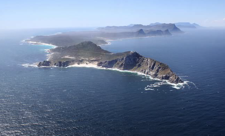
The Sinai Peninsula between the Red Sea’s Gulf of Aqaba and Gulf of Suez is a tectonic peninsula formed at the junction of the African Plate, the Arabian Plate, and the Sinai Microplate — three tectonic blocks whose divergence has created the V-shaped Red Sea and the Gulf of Aqaba. Covering approximately 60,000 square kilometers, Sinai is one of history’s most strategically significant landforms, the land bridge between Africa and Asia and the site of some of the ancient world’s most consequential military campaigns.
Erosional Peninsulas
Erosional peninsulas are formed when differential erosion removes softer surrounding rock more rapidly than the resistant rock of the peninsula itself, leaving the harder material projecting as a headland or peninsula from the general line of the coast or landscape. The shape of an erosional peninsula directly reflects the distribution of rock types and structures in the underlying geology.
Headlands along rocky coastlines are the most common expression of erosional peninsulas — promontories of resistant rock projecting from a coastline while the softer rocks on either side have been eroded back into bays and coves. The alternating headland-and-bay coastline of southwest England, the rugged promontories of the Brittany coast in France, and the rocky headlands of the Norwegian coast between fjords are all erosional peninsulas at various scales.
Land’s End at the southwestern tip of Cornwall in England is a classic erosional peninsula, its granite rocks — among the hardest in Britain — projecting into the Atlantic while the softer sedimentary rocks on either side have been eroded back. The granite cliffs of Land’s End rise approximately 60 to 70 meters from the sea and are estimated to be eroding at less than 1 millimeter per year, compared to rates of up to 2 meters per year for the soft clay cliffs of eastern England.
Depositional Peninsulas
Depositional peninsulas are built up by the accumulation of sediment — sand, gravel, and silt — transported by longshore drift, tidal currents, river deposition, or wind and deposited in elongated forms projecting from the coast. Unlike erosional peninsulas formed from pre-existing rock, depositional peninsulas are constructed features, built up grain by grain from transported material.
Spits — elongated ridges of sand and gravel extending from a headland into open water — are the most common form of depositional peninsula. Spurn Head on the Humber Estuary in Yorkshire, England, is a classic spit, extending approximately 5.5 kilometers from the Holderness coast in a curving finger of sand and gravel. It has been repeatedly breached and reformed throughout its history, demonstrating the ephemeral nature of depositional peninsulas.
Cape Cod in Massachusetts is one of the world’s most famous depositional peninsulas, its distinctive curved hook shape built entirely from glacial outwash sediments deposited by the retreating Laurentide Ice Sheet approximately 18,000 years ago and subsequently reworked by waves and longshore drift into its current form. Cape Cod covers approximately 1,000 square kilometers and extends approximately 105 kilometers into the Atlantic Ocean, its beaches losing an average of approximately 1 meter of shoreline per year to ongoing erosion.
Volcanic Peninsulas
Volcanic peninsulas are formed by the accumulation of volcanic material — lava flows, ash deposits, and volcanic cones — projecting into the sea from a coastline or building up from the ocean floor until the volcanic mass reaches the surface and forms a peninsula connected to the shore by a narrow neck of land or additional lava flows.
The Reykjanes Peninsula in southwestern Iceland is one of the world’s most active volcanic peninsulas, sitting directly on the Mid-Atlantic Ridge where the North American and Eurasian tectonic plates are pulling apart at approximately 2.5 centimeters per year. The peninsula covers approximately 1,800 square kilometers and has experienced dramatic volcanic activity in recent years — a series of eruptions beginning in 2021 on the Fagradalsfjall volcanic system have attracted global scientific and public attention, with lava flows transforming the landscape in real time.
The Kamchatka Peninsula in the Russian Far East — stretching approximately 1,200 kilometers southward from the Siberian mainland into the Pacific Ocean — is one of the world’s most volcanically active regions, containing 29 active volcanoes and lying directly above the subduction zone where the Pacific Plate dives beneath the Eurasian Plate. It covers approximately 270,000 square kilometers and its volcanoes — including Klyuchevskaya Sopka, the highest active volcano in the Northern Hemisphere at 4,750 meters — make it one of the planet’s most geologically dynamic landscapes.
River Delta Peninsulas
River delta peninsulas are formed when rivers deposit such large quantities of sediment at their mouths that the accumulated material builds outward into the sea, eventually forming a peninsula-like projection of new land extending beyond the general line of the coast. They are constructive features, growing as long as sediment supply exceeds the rate of wave and current erosion.
The Mississippi River Delta has built a distinctive bird’s-foot delta peninsula into the Gulf of Mexico, its multiple distributary channels extending as long, narrow fingers of deposited sediment far beyond the Louisiana coastline. The delta advances into the Gulf at approximately 90 meters per year in some channels, though this rate is now being reversed in many areas as sediment supply has been reduced by upstream dams and the delta itself subsides under its own weight at rates of up to 25 millimeters per year.
The Ganges-Brahmaputra Delta — the world’s largest delta, covering approximately 105,000 square kilometers — has built an enormous peninsula-like projection of sediment across the northern Bay of Bengal, creating the low-lying coastal Bangladesh and West Bengal plains. The delta receives an estimated 1 billion tons of sediment annually from the Himalayas, making it one of the most sediment-rich coastal systems on Earth, though rising sea levels threaten to submerge significant portions of this deltaic peninsula within decades.
Glacially Formed Peninsulas
Glacially formed peninsulas owe their shape and character primarily to the erosional and depositional work of glaciers and ice sheets during past ice ages, their outlines reflecting the pattern of glacial advance, retreat, and deposition rather than rock resistance, tectonic structure, or sediment accumulation.
The Cape Cod peninsula, as noted above, is a glacially formed depositional peninsula. More dramatically, the entire Scandinavian Peninsula owes much of its detailed shape — the fjords that create its extraordinarily indented western coastline, the numerous islands and skerries off its coast, and the broader pattern of its erosional landscape — to the work of the Scandinavian Ice Sheet that covered it entirely as recently as 10,000 years ago.
The Kola Peninsula of northwestern Russia — projecting approximately 400 kilometers into the Barents and White Seas — is a glacially scoured peninsula of ancient Precambrian rock, its surface scraped by the Scandinavian Ice Sheet into a landscape of polished bedrock, kettle lakes, and glacial deposits. Covering approximately 100,000 square kilometers, the Kola Peninsula contains the world’s largest known deposits of apatite — a phosphate mineral — and significant reserves of nickel, copper, and rare earth elements concentrated in its ancient crystalline rocks.
Submerged Peninsulas
Submerged peninsulas are former land peninsulas that have been partially or largely drowned by rising sea levels, leaving only their highest portions above water as a reduced peninsula, a chain of islands, or a combination of both. They record the dramatic rise in global sea levels — approximately 120 meters — that accompanied the melting of the great ice sheets at the end of the last Ice Age between approximately 20,000 and 7,000 years ago.
The Korean Peninsula provides an instructive example — during the last Ice Age, when sea levels were approximately 120 meters lower than today, the Yellow Sea between Korea and China was entirely dry land, and the Korean Peninsula was simply the southeastern edge of the Asian continental interior rather than a true peninsula at all. The flooding of the Yellow Sea as ice sheets melted transformed this continental margin into the peninsula it is today.
The Malay Peninsula — stretching approximately 1,100 kilometers southward from mainland Southeast Asia — sits on the Sunda Shelf, the submerged continental platform that was largely above water during glacial periods. Sea level rise drowned the Sunda Shelf approximately 10,000 to 14,000 years ago, transforming what had been a broad continental plain into the narrow peninsula and archipelago of islands — Sumatra, Java, Borneo — that characterize Southeast Asia today.
Cuspate Peninsulas
Cuspate peninsulas are triangular or cusp-shaped projections of land — typically low-lying and composed of sedimentary material — that form at the convergence of two sets of waves or longshore drift currents approaching from different directions. The meeting of these opposing sediment transport pathways causes deposition to concentrate at a point, building up a triangular landform projecting from the coast.
Cape Hatteras on the Outer Banks of North Carolina is one of the world’s most famous cuspate features, the southward-pointing tip of the Outer Banks marking the convergence of the cold Labrador Current flowing southward and the warm Gulf Stream flowing northward. The meeting of these two major ocean currents creates navigational hazards of legendary severity — the Diamond Shoals off Cape Hatteras have been called the Graveyard of the Atlantic, with over 1,000 documented shipwrecks in the area.
Cuspate forelands — broader, more stable cuspate accumulations — include features like Dungeness in Kent, England, the largest cuspate foreland in Europe, covering approximately 18 square kilometers of shingle and extending approximately 5 kilometers into the English Channel. Dungeness has been growing for approximately 5,000 years and advances seaward at approximately 1 meter per year, its surface covered by a distinctive vegetated shingle habitat of great ecological interest.
Arctic and Polar Peninsulas
Arctic and polar peninsulas are extensions of land projecting into polar seas, their character shaped by extreme cold, permafrost, sea ice, and the legacy of repeated glaciation. They are among the most remote and hostile peninsular environments on Earth and are of extraordinary scientific importance as sensitive recorders of climate change.
The Antarctic Peninsula is the world’s most southerly peninsula, extending approximately 1,300 kilometers northward from the Antarctic continent toward the tip of South America — the closest point of approach between Antarctica and another continent, separated from Tierra del Fuego by the approximately 800-kilometer-wide Drake Passage. Covering approximately 522,000 square kilometers, the Antarctic Peninsula has warmed by approximately 3°C over the past 50 years — faster than almost any other region on Earth — leading to the collapse of ice shelves including the dramatic disintegration of the Larsen B Ice Shelf in 2002.
The Taymyr Peninsula in Siberia — the northernmost point of the Asian mainland, projecting to approximately 77 degrees north latitude — covers approximately 400,000 square kilometers of Arctic tundra and is one of the least populated large land areas on Earth. It supports the world’s largest wild reindeer herd — the Taymyr herd — numbering approximately 400,000 to 600,000 animals, and its permafrost soils are thawing at accelerating rates, releasing significant quantities of carbon dioxide and methane into the atmosphere.
Isthmic Peninsulas
Isthmic peninsulas are peninsulas connected to the mainland by an unusually narrow isthmus — a thin neck of land sometimes only a few kilometers wide — that creates an almost-island quality to the landform and makes the peninsula strategically or geographically distinctive. The narrowness of the connecting isthmus often makes these peninsulas natural candidates for canal construction.
The Isthmus of Panama connecting North and South America is approximately 80 kilometers wide at its narrowest point, making the Central American land bridge one of the world’s most clearly isthmic connections between a peninsula-like landform and its continental mainland. The Panama Canal, completed in 1914 and expanded in 2016, cuts through this isthmus and carries approximately 14,000 vessels per year, representing approximately 5 percent of world trade by value.
The Crimean Peninsula in the Black Sea is connected to mainland Ukraine by the Perekop Isthmus — only approximately 5 to 7 kilometers wide — making it one of the most easily isolated large peninsulas in Europe. Covering approximately 27,000 square kilometers, Crimea has been one of history’s most contested territories precisely because of its strategic combination of near-insularity and mainland connection, commanding the approaches to the Black Sea and its surrounding civilizations for over 2,500 years.
Composite Peninsulas
Composite peninsulas are large, complex peninsular landforms whose shape and character reflect multiple geological and geomorphological processes operating simultaneously or sequentially — combining tectonic structure, volcanic activity, erosional modification, depositional infilling, and sea level change into a single complex landform.
The Iberian Peninsula — covering approximately 582,000 square kilometers and comprising Spain, Portugal, Andorra, and Gibraltar — is one of the world’s most clearly composite peninsulas. Its shape reflects the ancient Hercynian mountain building that created its Paleozoic basement, the Mesozoic sedimentary basins filled during periods of marine transgression, the Alpine tectonic activity that created the Pyrenees and Cantabrian Mountains, and the long history of differential erosion that has shaped its interior plateaus and coastal margins. The Meseta Central — the vast interior plateau averaging approximately 600 to 700 meters above sea level — covers approximately 60 percent of the peninsula’s total area.
The Florida Peninsula is another composite feature — its flat limestone surface representing ancient marine sediments deposited when the area was covered by a shallow tropical sea, subsequently modified by karst dissolution into a landscape of sinkholes and springs, and shaped along its coasts by depositional processes building beaches, barrier islands, and mangrove coasts. Florida extends approximately 500 kilometers southward from the North American mainland and covers approximately 170,000 square kilometers, its southern tip fringed by the only living coral barrier reef in the continental United States.