Plateaus are among the most distinctive and geologically significant landforms on the surface of the Earth — elevated, relatively flat or gently undulating expanses of terrain that stand conspicuously above the surrounding landscape, bounded on at least one side by steep escarpments or cliffs that mark the abrupt transition from the elevated surface to the lowlands below. They occupy a fascinating middle ground in the hierarchy of landforms — sharing the elevation and grandeur of mountains while possessing the open, sweeping character of plains — and they cover an estimated 45 percent of the Earth’s land surface, making them one of the most widespread of all landform types.
The geological origins of plateaus are remarkably diverse. Some are ancient remnants of once-vast mountain systems worn down by hundreds of millions of years of erosion until only their resistant foundations remain as elevated platforms. Others have been pushed upward by the collision of tectonic plates, their surfaces rising thousands of meters above sea level while remaining relatively undisturbed and flat. Still others have been built up by the outpouring of enormous volumes of volcanic lava that spread across the landscape in broad, flat sheets before cooling and hardening into elevated plains of dark basaltic rock. This diversity of origin produces an equally remarkable diversity of form, rock type, ecology, and human significance among the world’s plateaus.
Plateaus have profoundly shaped human history in ways that are easily underestimated. The Tibetan Plateau — the world’s largest and highest plateau, averaging over 4,500 meters above sea level across an area of approximately 2.5 million square kilometers — determines the climate of much of Asia, feeding ten of the continent’s greatest rivers and supporting the monsoon systems that deliver water to billions of people. The plateaus of East Africa provided the elevated, cooler environments in which the ancestors of modern humans evolved and from which they dispersed across the globe. The plateaus of the American West defined the geography of exploration and settlement, their dramatic escarpments serving as formidable barriers to westward expansion. Understanding the different types of plateaus is therefore essential to understanding both the physical and human geography of our planet.
Tectonic Plateaus
Tectonic plateaus are formed by the uplift of large sections of the Earth’s crust driven by the collision or compression of tectonic plates, producing elevated landmasses of extraordinary scale and altitude. They represent the most dramatic expression of tectonic forces operating at the Earth’s surface and include some of the highest and most extensive elevated surfaces on the planet.
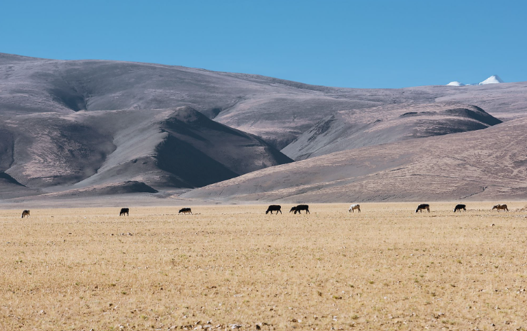
The Tibetan Plateau is the world’s supreme example of a tectonic plateau, formed by the ongoing collision of the Indian and Eurasian tectonic plates that began approximately 50 million years ago and continues today. The plateau averages approximately 4,500 meters above sea level across an area of 2.5 million square kilometers — roughly the size of Western Europe — and is so high and extensive that it creates its own climate system, driving the Asian monsoon and influencing atmospheric circulation patterns across the entire Northern Hemisphere. It is commonly referred to as the Roof of the World.
The Anatolian Plateau of Turkey, the Iranian Plateau, and the Altiplano of South America are other major tectonic plateaus formed by convergent plate tectonics. The Altiplano — shared between Peru, Bolivia, and Chile — averages approximately 3,750 meters above sea level and covers approximately 105,000 square kilometers, making it the world’s second highest plateau after Tibet. It contains Lake Titicaca, the world’s highest navigable lake at 3,812 meters above sea level.
Volcanic Plateaus
Volcanic plateaus are formed by the eruption of enormous volumes of low-viscosity basaltic lava from fissures and vents, spreading across the landscape in successive sheets that build up a flat or gently undulating elevated surface of solidified volcanic rock. They are among the most dramatic expressions of volcanism on Earth, their formation associated with some of the largest and most catastrophic eruptions in geological history.
The Deccan Plateau of peninsular India is one of the world’s largest volcanic plateaus, covering approximately 500,000 square kilometers of central and western India. It was formed between 60 and 68 million years ago by a series of catastrophic flood basalt eruptions that poured out an estimated 1 to 2 million cubic kilometers of lava — enough to bury the entire surface of the Indian subcontinent under several meters of rock. The individual lava flows that built the Deccan Plateau are exposed in the cliff faces of the Western Ghats escarpment, their layered stratigraphy recording successive eruptions over millions of years.
The Columbia Plateau of the northwestern United States covers approximately 160,000 square kilometers across Oregon, Washington, and Idaho, built up by the Columbia River Basalt Group — a series of flood basalt eruptions between 6 and 17 million years ago. The Snake River Plain cutting across southern Idaho is a younger volcanic plateau, its surface still dotted with recent lava flows and cinder cones. Iceland’s central highlands represent an active volcanic plateau still being built by ongoing eruptions along the Mid-Atlantic Ridge.
Dissected Plateaus
Dissected plateaus are plateaus that have been deeply cut by rivers, streams, and other erosional processes into a complex landscape of deep valleys, canyons, ridges, and isolated mesas that retain the general elevation of the original plateau surface while presenting a dramatically rugged and varied terrain at the local scale. Dissection transforms what was once a flat elevated surface into one of the most complex and visually spectacular of all landscapes.
The Colorado Plateau of the American Southwest is the world’s most celebrated dissected plateau, its surface cut by the Colorado River and its tributaries into a labyrinth of canyons, mesas, buttes, and arches of extraordinary geological complexity and beauty. The plateau covers approximately 337,000 square kilometers across Utah, Arizona, Colorado, and New Mexico, and the Grand Canyon — carved by the Colorado River through nearly 2 billion years of geological history to a depth of 1,857 meters — is its most dramatic expression. The plateau’s surface stands at approximately 2,000 to 2,500 meters above sea level, but the erosional dissection has created local relief of nearly 2,000 meters within the canyon systems.
The Appalachian Plateau of the eastern United States, the Loess Plateau of northern China — deeply dissected by the Yellow River and its tributaries into a maze of gullies and ridges — and the plateau landscapes of the Ethiopian Highlands are other major examples of dissected plateaus. The Loess Plateau covers approximately 640,000 square kilometers and has been so intensively dissected and eroded that it contributes the vast majority of the Yellow River’s enormous sediment load — approximately 1.6 billion tons of sediment per year.
Intermontane Plateaus
Intermontane plateaus are elevated plains enclosed on multiple sides by mountain ranges, forming elevated basins or tablelands nestled between or surrounded by high peaks. They are created by a combination of tectonic uplift, volcanic activity, and sediment filling of enclosed basins, and they are typically among the highest and most isolated of all plateau types.
The Tibetan Plateau is technically an intermontane plateau as well as a tectonic one, enclosed to the south by the Himalayas, to the north by the Kunlun and Altyn Tagh ranges, and to the west by the Karakoram. The Bolivian Altiplano is another classic intermontane plateau, enclosed between the Cordillera Occidental and the Cordillera Oriental — the two parallel ranges of the Andes — at an average elevation of approximately 3,750 meters. The enclosed nature of the Altiplano has created a series of large, shallow lakes and salt flats, including the Salar de Uyuni — the world’s largest salt flat at approximately 10,582 square kilometers.
The Mexican Plateau, enclosed between the Sierra Madre Occidental and Sierra Madre Oriental, covers approximately 700,000 square kilometers at elevations between 1,000 and 2,500 meters and is home to the majority of Mexico’s population, including Mexico City. The Great Basin of the western United States, though more of an intermontane basin than a true plateau, shares many characteristics of intermontane plateau environments.
Piedmont Plateaus
Piedmont plateaus are elevated plains located at the foot of mountain ranges, representing either ancient erosion surfaces that have been uplifted relative to the surrounding lowlands, or the accumulated outwash and sedimentary deposits from the eroding mountains above. The word piedmont comes from the Italian for “foot of the mountain,” and piedmont plateaus are transitional features between the highland terrain of mountain ranges and the lowland plains beyond.
The Piedmont Plateau of the eastern United States — stretching from New Jersey southward to Alabama between the Appalachian Mountains to the west and the Atlantic Coastal Plain to the east — is one of the most clearly defined piedmont plateau landscapes in the world. It represents an ancient erosion surface developed on the hard metamorphic and igneous rocks of the Appalachian interior, standing at elevations of 100 to 500 meters above the coastal plain. The Fall Line — where the hard rocks of the Piedmont meet the soft sediments of the Coastal Plain — is marked by falls and rapids on every river crossing it and historically concentrated the first industrial mills and cities of the American East.
The Mysore Plateau of southern India, the Meseta Central of Spain, and the Patagonian Plateau of Argentina all share piedmont characteristics, their surfaces representing ancient erosion or deposition surfaces elevated relative to surrounding lowlands by tectonic activity or the differential erosion of surrounding less resistant terrain.
Lava Plateaus
Lava plateaus are a specific subset of volcanic plateaus formed by the accumulation of successive lava flows from fissure eruptions, building up elevated surfaces of basaltic rock over periods of millions of years. Unlike volcanic cones and stratovolcanoes that build up individual peaks, the fissure eruptions that create lava plateaus produce vast sheets of low-viscosity lava that spread across hundreds of thousands of square kilometers before cooling and hardening.
The Ethiopian Plateau — one of Africa’s most extensive elevated regions, covering approximately 350,000 square kilometers at elevations largely between 2,000 and 3,000 meters — is primarily a lava plateau, built up by flood basalt eruptions associated with the development of the East African Rift System between 30 and 75 million years ago. Its fertile soils, derived from weathered basaltic rock, support dense agricultural populations and were the cradle of coffee cultivation — Ethiopia remains one of the world’s leading coffee producers, growing the beverage’s original wild varieties in its highland forests.
The Paraná Plateau of southern Brazil, Argentina, and Uruguay — formed by flood basalt eruptions approximately 130 million years ago — covers approximately 1.2 million square kilometers and is the source of the basaltic rock over which the Iguazu Falls plunges. The Siberian Traps — an ancient lava plateau in Siberia formed by eruptions approximately 252 million years ago — cover approximately 2 million square kilometers and are associated with the Permian-Triassic mass extinction, the largest extinction event in Earth’s history, which wiped out approximately 96 percent of all marine species.
Continental Plateaus (Shield Plateaus)
Continental plateaus, also known as shield plateaus or cratonic plateaus, are elevated surfaces developed on ancient Precambrian basement rocks — the stable cores of continents that have been tectonically quiet for hundreds of millions to billions of years. They represent some of the oldest exposed rock surfaces on Earth, their elevations maintained not by active tectonic uplift but by the isostatic buoyancy of their thick, cold, and relatively low-density crustal roots.
The Brazilian Highlands — covering approximately 4.5 million square kilometers across central and eastern Brazil — are one of the world’s largest continental plateau systems, their surfaces developed on Precambrian basement rocks between 300 million and 3.5 billion years old. The plateau averages approximately 1,000 meters above sea level and is the source of the São Francisco River and many tributaries of the Amazon and Paraná river systems. The dramatic escarpment of the Serra do Mar, dropping sharply to the Atlantic coastal plain, is one of South America’s most striking geological features.
The Arabian Plateau, the West Australian Shield, and the Laurentian Plateau of Canada are other major continental plateaus. The Laurentian Plateau — essentially the exposed surface of the Canadian Shield — covers approximately 4.8 million square kilometers of central and eastern Canada, its ancient Precambrian rocks representing some of the oldest exposed crust on Earth at up to 4 billion years of age.
Karst Plateaus
Karst plateaus are elevated surfaces developed on soluble limestone or dolomite rock, where the dissolution of the bedrock by acidic groundwater has produced a distinctive landscape of sinkholes, caves, dry valleys, and disappearing streams overlying an extraordinarily complex underground drainage system. The flat surfaces of karst plateaus are constantly being lowered and modified by dissolution, and the underground voids created by this process make karst plateaus uniquely vulnerable to sudden collapse.
The Causses plateaus of southern France — a series of elevated limestone platforms separated by deep river gorges cut by the Lot, Tarn, and Dourbie rivers — are among Europe’s most celebrated karst plateau landscapes. They average approximately 800 to 1,200 meters above sea level and are underlain by cave systems of extraordinary extent, including the Grotte de Clamouse and the caves of the Gorge du Tarn. The surface of the Causses is characterized by a sparse, dry vegetation of scrub and grassland — the garrigue — developed on thin soils over the porous limestone.
The Guizhou Plateau of southwestern China — covering approximately 176,000 square kilometers at elevations largely between 1,000 and 2,000 meters — is one of the world’s most extensive karst plateau landscapes, its surface riddled with sinkholes, stone forests, and natural bridges. The Nullarbor Plain of southern Australia — whose name comes from the Latin for “no trees,” reflecting the sparse vegetation of the flat limestone surface — covers approximately 200,000 square kilometers and is underlain by one of the world’s most extensive cave systems, with individual caves stretching for tens of kilometers.
Structural Plateaus
Structural plateaus are elevated surfaces whose flat character reflects the underlying geological structure — most commonly the horizontal or near-horizontal bedding of sedimentary rock layers — rather than being produced by erosion or volcanic activity. They are essentially uplifted sections of originally flat-lying sedimentary sequences that have been elevated by tectonic forces while retaining their original horizontal structure.
The Great Plains of North America are partly a structural plateau — their flat surfaces reflecting the nearly horizontal bedding of Cretaceous and Tertiary sedimentary rocks that were gently tilted eastward as the Rocky Mountains rose to the west. The surface dips almost imperceptibly from approximately 1,500 meters at the foot of the Rockies to approximately 500 meters at the Missouri River, a distance of over 800 kilometers. This structural simplicity, combined with the deep, fertile soils developed on the sedimentary substrate, makes the Great Plains one of the world’s most productive agricultural regions.
The Appalachian Plateaus section of the eastern United States — including the Allegheny and Cumberland Plateaus — is a classic structural plateau, its surface underlain by nearly flat-lying Paleozoic sedimentary rocks that have been uplifted as a block relative to the surrounding lowlands. The Kaibab Plateau in northern Arizona, forming the North Rim of the Grand Canyon, is a beautifully clear example of a structural plateau, its flat surface reflecting the horizontal bedding of Permian and Triassic sedimentary rocks.
Desert Plateaus
Desert plateaus are elevated flat or gently undulating surfaces in arid or hyper-arid environments, where the combination of high elevation and aridity creates some of the most extreme and challenging environments on Earth. The aridity of desert plateaus is typically a product of their continentality — their distance from moisture-bearing ocean winds — combined in many cases with the rain shadow effect of surrounding mountain ranges that strip moisture from approaching air masses.
The Tibetan Plateau, in addition to being a tectonic plateau, functions as a vast desert plateau across much of its interior, where the combination of extreme altitude, continental position, and rain shadow effects of the Himalayas to the south produce hyper-arid conditions. The Changtang — the high plateau steppe of northern Tibet and western Qinghai — receives less than 150 millimeters of precipitation annually across vast areas and supports one of the most sparsely populated environments on Earth, though it is home to remarkable wildlife including Tibetan antelope, wild yak, and snow leopard.
The Atacama Plateau of northern Chile and southern Peru — part of the broader Puna de Atacama — averages approximately 3,500 meters above sea level and receives less than 50 millimeters of precipitation annually across much of its extent, making it one of the highest and driest plateaus on Earth. The plateau surface is studded with active volcanoes, salt flats, and colored mineral lakes of extraordinary beauty, including the Laguna Colorada — a shallow salt lake colored red by algae and borax deposits — and the Laguna Verde, colored green by the minerals dissolved in its waters.
Glaciated Plateaus
Glaciated plateaus are elevated surfaces that have been extensively modified by glacial erosion and deposition during past or present ice ages, their surfaces scoured by ice sheets into landscapes of polished bedrock, glacial lakes, moraines, and depositional plains quite different in character from unglaciated plateaus of similar elevation and geology. The passage of ice sheets across plateau surfaces leaves distinctive signatures in the landscape that persist for thousands of years after the ice retreats.
The Scandinavian Plateau — the Hardangervidda and the broader fell landscapes of Norway, Sweden, and Finland — are among the world’s most extensively glaciated plateau surfaces, their ancient Precambrian and Caledonian rocks scraped nearly bare by successive Scandinavian Ice Sheets. The Hardangervidda plateau in Norway, covering approximately 8,000 square kilometers at an average elevation of 1,100 meters, is Europe’s largest mountain plateau and was completely covered by ice as recently as 10,000 years ago. Today it is dotted with thousands of glacially carved lakes and supports Europe’s largest wild reindeer population of approximately 10,000 animals.
The Laurentian Plateau of Canada — the exposed surface of the Canadian Shield — has been repeatedly glaciated by the Laurentide Ice Sheet and is one of the world’s most lake-rich landscapes, with an estimated one million lakes covering approximately 12 percent of its surface. The muskeg bogs, boreal forests, and tundra that cover much of the Laurentian Plateau today are directly inherited from the ecological succession that has followed the retreat of the last ice sheet over the past 12,000 years.
Submarine Plateaus
Submarine plateaus are large, relatively flat elevated areas of the ocean floor that rise significantly above the surrounding deep ocean basins but remain submerged below the ocean surface. They are geologically diverse — some are submerged fragments of continental crust, others are volcanic constructions, and others are ancient ocean floor elevated by hotspot activity or tectonic processes — and they play important roles in ocean circulation and marine ecology.
The Kerguelen Plateau in the southern Indian Ocean is the world’s largest submarine plateau, covering approximately 2.2 million square kilometers — roughly the size of India — at water depths of 500 to 1,500 meters above the surrounding ocean floor. It represents a fragment of continental crust rifted away from the supercontinent Gondwana approximately 130 million years ago and subsequently partially covered by flood basalts from the Kerguelen hotspot. The small islands of Kerguelen, Heard Island, and McDonald Islands represent the highest points of the plateau, barely breaching the ocean surface.
The Ontong Java Plateau in the western Pacific — the world’s largest oceanic plateau — covers approximately 1.9 million square kilometers and was formed by one of the largest volcanic events in Earth’s history approximately 122 million years ago, when an enormous outpouring of basaltic lava built up a submarine plateau up to 30 kilometers thick. The Chatham Rise east of New Zealand, the Falkland Plateau in the South Atlantic, and the Mascarene Plateau in the Indian Ocean are other significant submarine plateaus of considerable oceanographic importance.
Coastal Plateaus
Coastal plateaus are elevated flat or gently sloping surfaces that drop abruptly to the sea along one or more sides, their seaward escarpments forming some of the world’s most dramatic coastal cliff landscapes. They are found on tectonically passive continental margins where ancient erosion surfaces have been uplifted relative to sea level, or where resistant rock formations have resisted the marine erosion that has lowered surrounding terrain.
The Great Escarpment of southern Africa is the most dramatic coastal plateau margin in the world, the elevated surface of the African Plateau dropping abruptly to the coastal lowlands in a series of spectacular escarpments that run almost continuously for approximately 5,000 kilometers from Angola through Namibia, South Africa, Lesotho, eSwatini, and Mozambique. The Drakensberg section of the Great Escarpment reaches heights of over 3,400 meters and forms one of the most impressive mountain and plateau landscapes in Africa.
The Western Ghats of India form the escarpment of the Deccan Plateau along its western margin, dropping sharply to the narrow Malabar Coast below in a series of cliffs and waterfalls that capture most of the moisture from the southwest monsoon winds, creating one of Asia’s biodiversity hotspots on the wetter western slopes while leaving the plateau interior in a pronounced rain shadow. The Nullarbor Plain of southern Australia drops to the Great Australian Bight in the Bunda Cliffs — a continuous limestone escarpment stretching approximately 210 kilometers — one of the world’s longest unbroken sea cliffs.