Settlements are among the most fundamental expressions of human geography — the places where people choose, or are compelled, to live, work, and organize their social lives in relationship to the land, resources, and other people around them. A settlement is broadly defined as any place where people have established a permanent or semi-permanent residence, ranging from a single isolated farmstead to a megacity of tens of millions of inhabitants. The study of settlements — their location, form, function, growth, and decline — lies at the heart of human geography, offering a window into the complex interplay of physical environment, economic forces, cultural traditions, political structures, and historical circumstances that shape the human landscape.
The world’s settlement patterns today reflect an extraordinary diversity of forms, scales, and historical origins. Approximately 8.1 billion people live in settlements ranging from tiny hamlets of a dozen households to metropolitan agglomerations of 30 million or more. For the first time in human history, more than half of the world’s population — approximately 56 percent, or 4.4 billion people — now lives in urban settlements, a proportion that is projected to reach 68 percent by 2050. This urbanization represents one of the most dramatic and consequential geographical transformations in human history, reshaping landscapes, ecosystems, economies, and social relationships at a global scale. Yet billions of people continue to live in rural settlements of every conceivable form, maintaining agricultural, pastoral, fishing, and forest-based livelihoods that have sustained human communities for millennia.
The geography of settlements is not random. Human communities have consistently chosen settlement locations that offer access to water, fertile soils, navigable rivers, natural harbors, defensible terrain, and mineral resources — the fundamental requirements of human subsistence and security. The great river valleys of the Nile, the Tigris-Euphrates, the Indus, and the Yellow River concentrated the world’s earliest urban settlements precisely because they offered the combination of water, fertile alluvial soils, and agricultural surplus that made dense human settlement possible. Coastal locations, crossroads positions on trade routes, and mineral-rich areas have similarly attracted human settlement throughout history, explaining the persistence of many settlement locations over thousands of years even as the economic and political systems that sustained them have changed beyond recognition.
Dispersed Settlements
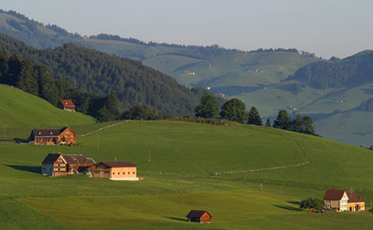
Dispersed settlements are characterized by individual dwellings — farmsteads, homesteads, and isolated houses — spread across the landscape at considerable distances from one another, with no nucleated village center or clustered residential core. Each dwelling typically sits on or near the land it works, reflecting a direct spatial relationship between residence and agricultural or pastoral resource.
Dispersed settlement patterns are most common in areas where agricultural systems require large landholdings per family — extensive livestock ranching, large-scale arable farming, or shifting cultivation — and where physical conditions such as water availability, terrain, or soil quality distribute agricultural resources unevenly across the landscape. The rural landscapes of the American Midwest, the Canadian prairies, the Australian outback, and the upland areas of Britain and Ireland are characterized by dispersed settlement patterns. In Ireland, approximately 40 percent of the rural population lives in dispersed single-family dwellings rather than in villages — a pattern reflecting centuries of historical land tenure, the absence of a strong nucleated village tradition, and the dominance of family farming.
Nucleated Settlements
Nucleated settlements are those in which dwellings and other buildings are clustered together in a compact group — a village, hamlet, or small town — with agricultural and other land uses extending outward from the residential core. The clustering of dwellings reflects a variety of motivations — mutual defense, communal farming systems, access to shared water sources, religious or administrative functions, or simply the social preference for proximity to neighbors.
Nucleated settlements are the dominant rural settlement form across much of Europe, South Asia, the Middle East, and Africa, where village life has been the foundation of rural society for thousands of years. In South Asia, approximately 640,000 villages contain the majority of the subcontinent’s rural population — India alone has approximately 600,000 villages with an average population of approximately 1,000 people each. The nucleated village has historically provided communities with security against raiders, shared access to common grazing lands and water sources, and the social infrastructure of temples, mosques, markets, and meeting places that sustains community life.
Linear Settlements
Linear settlements are those in which dwellings and other buildings are arranged in a line — along a road, a river bank, a canal, a coastline, or a valley floor — producing an elongated, ribbon-like settlement form that follows a linear geographical feature rather than clustering around a central point. The linear arrangement directly reflects the importance of the route or waterway along which it has developed.
Linear settlements are found in virtually every part of the world wherever a road, river, or coastline has attracted settlement along its length. The ribbon development that spread along major roads out of British cities in the interwar period — when improved transport allowed suburbanization along arterial routes — is a classic linear settlement form. In the polder landscapes of the Netherlands, farmsteads are characteristically arranged in long linear sequences along drainage ditches and dikes, their narrow strip fields extending back from the waterway in a pattern that has remained essentially unchanged since medieval land reclamation created these landscapes. Linear settlements along the Nile Valley — where the ribbon of cultivable land is only a few kilometers wide on either side of the river — have housed Egyptian civilization for over 5,000 years.
Urban Settlements
Urban settlements are concentrations of population characterized by high population density, economic specialization in non-agricultural activities, the provision of services and infrastructure, and administrative and cultural functions that serve surrounding hinterlands. They are the dominant settlement type by population in the modern world, housing the majority of humanity for the first time in history.
The world’s urban population reached approximately 4.4 billion in 2022 — 56 percent of the global total — up from just 751 million in 1950. The most rapid urbanization is occurring in sub-Saharan Africa and Asia, where urban populations are projected to nearly double by 2050. The world currently has 33 megacities — urban agglomerations with populations exceeding 10 million — compared to just two in 1950. Tokyo remains the world’s largest urban agglomeration, with a metropolitan population of approximately 37 million people, followed by Delhi at approximately 32 million and Shanghai at approximately 29 million.
Rural Settlements
Rural settlements are communities located outside the urban system, typically characterized by lower population density, a closer relationship between settlement and agricultural or natural resource use, and a lifestyle and social structure shaped by the rhythms and requirements of farming, fishing, forestry, or pastoralism. They are the oldest and most widespread settlement type in human history, having housed the vast majority of humanity for most of the past 10,000 years.
Approximately 3.4 billion people — 44 percent of the global population — still live in rural settlements, though this proportion is declining rapidly as urbanization accelerates across the developing world. Rural settlements vary enormously in size, form, and function — from tiny hamlets of a few dozen people in remote mountain areas to substantial market towns of several thousand that serve as commercial and service centers for surrounding farming communities. In sub-Saharan Africa, where urbanization is less advanced than in other developing regions, approximately 58 percent of the population remains rural, and the rural village continues to be the primary social and economic unit for the majority of the continent’s people.
Planned Settlements
Planned settlements are those deliberately designed and laid out according to a predetermined plan — by governments, colonizing powers, religious organizations, private developers, or other agencies — rather than evolving organically through the gradual accretion of individual building decisions. They are characterized by regularity of layout, systematic allocation of land uses, and a deliberate spatial organization that reflects the values and priorities of their designers.
Planned settlements range in scale from the grid-pattern new towns established by the British colonial government across India, Africa, and the Caribbean to the purpose-built capital cities of the 20th century — Brasília, Canberra, Islamabad, Naypyidaw, and Abuja among them. Brasília, designed by urban planner Lúcio Costa and architect Oscar Niemeyer and inaugurated in 1960, was built on an entirely uninhabited plateau in the Brazilian interior to shift the country’s political center of gravity away from the coastal cities, and now houses approximately 3.1 million people. Planned industrial settlements — company towns built around mines, factories, and mills — were characteristic of 19th and early 20th century industrialization, with examples including Pullman, Illinois in the United States and Bournville in England.
Spontaneous Settlements (Informal Settlements)
Spontaneous settlements, also known as informal settlements, squatter settlements, or slums, are residential areas that develop without official planning permission or legal land tenure, typically on the margins of cities in developing countries where rapid urbanization has outpaced the capacity of governments and housing markets to provide adequate formal housing. They are characterized by self-built shelters of improvised materials, lack of basic services — clean water, sanitation, electricity, paved roads — and insecure tenure that leaves residents vulnerable to eviction.
Approximately 1.1 billion people — roughly 24 percent of the world’s urban population — currently live in informal settlements, and this number is projected to reach 3 billion by 2050 if current trends continue. The largest informal settlements in the world include Dharavi in Mumbai — often described as Asia’s largest slum, housing approximately 600,000 to 1 million people in approximately 2.1 square kilometers — Kibera in Nairobi, which houses an estimated 200,000 to 500,000 people, and the favelas of Rio de Janeiro, which house approximately 1.4 million people across over 700 communities. Despite their difficult conditions, informal settlements often develop remarkable internal social organization, economic vitality, and community institutions that sustain their populations and provide pathways toward greater security and prosperity.
Coastal Settlements
Coastal settlements are communities established on or near coastlines — on beaches, cliffs, estuaries, harbors, and river mouths — drawn to the coast by the resources and opportunities of the marine environment, including fisheries, maritime trade, salt production, and the strategic advantages of coastal location. They represent one of the oldest and most widespread settlement types in human history.
Approximately 40 percent of the world’s population lives within 100 kilometers of a coastline, and approximately 10 percent — over 800 million people — lives in low-elevation coastal zones less than 10 meters above sea level. Coastal settlements range from tiny fishing villages of a few dozen households to the world’s greatest port cities — Shanghai, Singapore, Rotterdam, Mumbai, and New York — whose wealth and growth have been driven by their command of maritime trade. The concentration of population and economic assets in coastal settlements makes them acutely vulnerable to the rising sea levels, intensifying storms, and coastal erosion associated with climate change — the World Bank estimates that without adaptation measures, coastal flooding could affect up to 1 billion people annually by 2050.
Mountain Settlements
Mountain settlements are communities established at high elevations in mountainous terrain, adapted to the distinctive challenges and opportunities of mountain environments — steep slopes, thin soils, harsh winters, isolation, and limited flat land for agriculture, combined with summer pastures, forest resources, mineral deposits, and the strategic value of passes and defensible positions.
Mountain settlements are found on every inhabited continent, from the high Andean communities of Peru and Bolivia — some at elevations exceeding 4,000 meters, making them among the highest permanently inhabited places on Earth — to the alpine villages of Switzerland and Austria, the highland settlements of Ethiopia and Nepal, and the mountain communities of the American Appalachians and Rockies. La Rinconada in Peru, at approximately 5,100 meters above sea level, is the world’s highest permanently inhabited settlement, with approximately 30,000 people living in extremely harsh conditions to work the gold mine that sustains the community. Mountain settlements have historically developed strong traditions of transhumance — the seasonal movement of livestock between valley floor winter pastures and high-altitude summer meadows — and of specialized craft production and trade to supplement the limited agricultural productivity of steep, thin-soiled mountain terrain.
Island Settlements
Island settlements are communities established on islands — surrounded entirely by water and therefore dependent on maritime connections for trade, communication, and supply. Their insularity shapes every aspect of their geography — their resource base is limited to what the island itself provides and what can be economically imported, their populations are typically small relative to mainland communities, and their cultures and ecosystems are shaped by the isolation and self-sufficiency that island life demands.
The world has approximately 900,000 islands, and a significant proportion of these are permanently inhabited. Approximately 600 million people live on islands worldwide — about 7.5 percent of the global population. The largest island nations by population include Indonesia — an archipelago of over 17,000 islands with a population of approximately 277 million — the Philippines with approximately 115 million people on over 7,000 islands, and Japan with approximately 125 million people. Small island developing states — including Maldives, Tuvalu, Kiribati, and the Marshall Islands — face existential threats from sea level rise, with some projecting that their entire land area could be submerged within decades, raising unprecedented questions about the future of island settlements and the fate of their displaced populations.
Temporary and Nomadic Settlements
Temporary and nomadic settlements are residential arrangements that are intentionally impermanent — designed to be established, used for a period, and then dismantled and relocated as the community moves to new resources, pastures, or opportunities. They represent the oldest form of human settlement, predating permanent agriculture by hundreds of thousands of years, and are still practiced by millions of people worldwide.
Nomadic and semi-nomadic pastoralists — who move their herds of cattle, sheep, goats, camels, or reindeer between seasonal grazing areas — represent the largest group of people maintaining nomadic settlement patterns. Approximately 200 million people worldwide practice some form of mobile pastoralism, including the Mongolian herders of Central Asia, the Tuareg and Fulani of the Sahara and Sahel, the Maasai of East Africa, and the Sami reindeer herders of Scandinavia.
Mongolia — where approximately 30 percent of the population remains nomadic or semi-nomadic, living in portable felt tents called gers — is the country with the highest proportion of its population maintaining nomadic settlement patterns in the modern world. The ger districts on the outskirts of Ulaanbaatar, housing approximately 60 percent of the capital’s population of 1.6 million, represent a fascinating hybrid settlement type where nomadic housing forms have been adapted to a permanent urban fringe context.
Market Town Settlements
Market towns are nucleated settlements that developed around periodic or permanent markets — gathering places for the exchange of agricultural produce, livestock, craft goods, and services between rural producers and traders. They occupy a crucial middle position in the settlement hierarchy between the village and the city, serving as commercial and service centers for the surrounding agricultural hinterland.
Market towns are found across the world wherever agricultural surplus has generated demand for exchange and commerce, but they are most clearly developed in the rural landscapes of Europe, West Africa, South Asia, and East Asia. In medieval England, market towns were established by royal charter at regular intervals across the landscape — typically 10 to 15 kilometers apart, representing a comfortable day’s return journey on foot for a farmer bringing produce to market.
Approximately 600 market towns were established in England between 1200 and 1350, and many of these settlements retain their market functions, their characteristic market squares, and their historic built environments to the present day. In West Africa, the periodic market system — where markets rotate between different villages on different days of the week — creates a dynamic settlement hierarchy in which individual villages take on urban functions temporarily as the market comes to them.
Industrial Settlements
Industrial settlements are communities that developed primarily around manufacturing, mining, or energy production rather than around agriculture, trade, or administrative functions. They are the characteristic settlement type of the Industrial Revolution and its aftermath, arising wherever the concentration of raw materials, energy sources, and labor created opportunities for large-scale factory production.
Industrial settlements range from the coal mining villages of South Wales and County Durham in England — compact communities of terraced housing built to house miners and their families around collieries that have now largely closed — to the massive industrial cities of the Ruhr Valley in Germany, the steel towns of the American Midwest, and the manufacturing cities of China’s Pearl River Delta. The Ruhr region of western Germany — a conurbation of industrial cities including Essen, Dortmund, Duisburg, and Bochum — grew from a rural landscape of scattered farms to an urban agglomeration of approximately 5.1 million people within a century of the onset of coal mining and steel production in the mid-19th century.
Many industrial settlements have faced severe economic and social challenges as the industries that created them have declined — the deindustrialization of the American Rust Belt, the British coalfields, and the heavy industrial regions of eastern Europe has left many industrial settlements with high unemployment, population loss, and deteriorating infrastructure, creating the phenomenon of shrinking cities that is one of the most challenging planning problems of the 21st century.