Desertification is one of the most insidious and far-reaching environmental crises of the modern era — the process by which fertile, productive land in arid, semi-arid, and dry sub-humid regions is degraded into barren, desert-like conditions through a combination of climatic variation and human activities that strip the land of its vegetation, destroy its soil structure, and exhaust its capacity to support plant and animal life. Unlike deforestation, which is often a dramatic and visible event, desertification typically advances gradually and almost imperceptibly — a slow, creeping transformation that may take decades to become fully apparent but is extraordinarily difficult and expensive to reverse once established.
The global scale of desertification is alarming. Approximately 40 percent of the Earth’s total land surface — roughly 5.2 billion hectares — consists of drylands vulnerable to desertification, and of this area, approximately 24 percent is already degraded. The United Nations Convention to Combat Desertification estimates that up to 12 million hectares of productive land are lost to desertification and drought every year — an area equivalent to Benin or Honduras — while approximately 1.5 billion people worldwide directly depend on degraded land for their livelihoods. The economic costs of desertification are estimated at approximately 42 billion dollars per year in lost agricultural productivity alone, not counting the broader social and environmental costs of land degradation, forced migration, and ecosystem collapse.
The consequences of desertification extend far beyond the loss of agricultural productivity. Desertified land contributes to dust storms that carry hundreds of millions of tons of soil particles across continents annually, damaging crops, reducing air quality, and depositing sediment in rivers and coastal waters. Desertification forces the displacement of rural communities, contributing to urbanization pressures in developing countries and in some cases to international migration. It reduces biodiversity, depletes groundwater resources, increases the frequency and severity of floods and droughts, and contributes to the vicious cycles of poverty, food insecurity, and political instability that characterize many of the world’s dryland regions. Understanding the different types of desertification — their causes, their geographic expressions, and their consequences — is essential to developing the integrated approaches needed to address one of the 21st century’s most pressing environmental challenges.
Wind Erosion Desertification
Wind erosion desertification occurs when the removal of vegetation — by overgrazing, drought, or unsustainable cultivation — exposes bare soil to the erosive force of wind, which strips away the finest and most nutrient-rich particles of topsoil and leaves behind a coarser, less fertile residue. Over time, the progressive loss of the fertile surface layer destroys soil structure, reduces water retention, and eliminates the capacity of the land to support plant regrowth.
Wind erosion is one of the most powerful and far-reaching forms of land degradation on Earth, capable of transporting billions of tons of soil particles across continents and oceans. The Sahara Desert contributes approximately 182 million tons of dust to the Atlantic Ocean annually — some of which fertilizes the Amazon rainforest — while the deserts of Central Asia generate dust storms that reduce air quality across China, Korea, and Japan. In severely wind-eroded areas, the topsoil layer that took thousands of years to develop can be stripped away in a single severe dust storm event.
Water Erosion Desertification
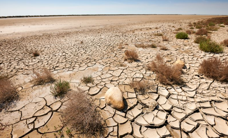
Water erosion desertification occurs when the loss of vegetation cover and the degradation of soil structure — caused by overgrazing, unsustainable farming, or deforestation — leave the soil vulnerable to the erosive power of rain and surface runoff. Without a protective cover of plants and a stable soil structure held together by roots and organic matter, rainfall impacts dislodge soil particles, surface runoff transports them downslope, and gully systems develop that progressively dissect and remove the productive soil layer.
Water erosion removes approximately 75 billion tons of soil from agricultural and degraded land globally each year — at a rate estimated to be 13 to 40 times faster than the natural rate of soil formation. The Loess Plateau of northern China — covering approximately 640,000 square kilometers — is one of the world’s most severely water-eroded landscapes, contributing approximately 1.6 billion tons of sediment to the Yellow River annually before major restoration efforts beginning in the 1990s. Severe gully erosion — the development of deep channels carved by concentrated runoff — can render land completely uncultivable within years of vegetation loss.
Overgrazing Desertification
Overgrazing desertification is the most widespread type of desertification globally, occurring when livestock numbers exceed the carrying capacity of the land — the maximum number of animals the vegetation can sustainably support — resulting in the progressive destruction of plant cover, compaction of soil by animal hooves, and transformation of productive rangeland into bare, eroded, desert-like terrain.
Approximately 70 percent of the world’s drylands used for agriculture are considered degraded, with overgrazing identified as the primary cause in the majority of cases. The Sahel region of Africa — the semi-arid zone stretching approximately 5,400 kilometers across the continent from Senegal to Eritrea — has been severely affected by overgrazing desertification, with livestock populations growing from approximately 40 million animals in 1950 to over 170 million today, far exceeding the sustainable carrying capacity of the region’s fragile dryland ecosystems. The social and economic pressures driving overgrazing — poverty, population growth, the breakdown of traditional grazing management systems, and the loss of dry-season grazing reserves — make it one of the most difficult types of desertification to address.
Agricultural Desertification
Agricultural desertification occurs when unsustainable farming practices — intensive cultivation without adequate fallowing, monoculture cropping that depletes soil nutrients, irrigation that causes salinization and waterlogging, and the removal of field-boundary trees and hedges that protect soils from wind and water erosion — progressively degrade the productive capacity of farmland in dryland regions until it can no longer sustain cultivation.
Soil salinization — the accumulation of salts in the soil profile caused by irrigation with water that carries dissolved minerals — is one of the most serious forms of agricultural desertification, affecting approximately 20 percent of the world’s irrigated agricultural land and causing productivity losses estimated at 27 billion dollars per year. The Aral Sea basin of Central Asia represents perhaps the world’s most catastrophic example of irrigation-driven agricultural desertification — the diversion of the Amu Darya and Syr Darya rivers for cotton irrigation caused the Aral Sea to shrink from approximately 68,000 square kilometers in 1960 to less than 10 percent of its original size by 2010, leaving behind a vast salt desert that generates toxic dust storms affecting millions of people across the region.
Deforestation-Driven Desertification
Deforestation-driven desertification occurs when the removal of forest cover — for agriculture, fuelwood, or timber — in dryland and sub-humid regions triggers a cascade of ecological changes that progressively transform the landscape toward desert-like conditions. Forests in dryland regions play a critical role in maintaining rainfall, moderating temperatures, anchoring soils, and recycling water through evapotranspiration — their removal can set in motion self-reinforcing feedback loops that ultimately eliminate the conditions necessary for forest regeneration.
The relationship between deforestation and rainfall reduction is particularly critical in semi-arid regions where much of the precipitation is generated locally through the evapotranspiration of the forest itself. Studies in the Sahel have estimated that deforestation has reduced regional rainfall by approximately 10 to 25 percent since the 1960s, contributing significantly to the droughts and desertification that have devastated the region. Haiti — which has lost approximately 98 percent of its original forest cover through centuries of deforestation — presents one of the starkest examples of deforestation-driven desertification in the world, its denuded hillsides experiencing catastrophic soil erosion, loss of water retention, and progressive conversion of previously fertile land to barren rock and gully systems.
Climate Change Desertification
Climate change desertification occurs when shifts in temperature and precipitation patterns driven by global warming push dryland regions beyond the climatic thresholds that sustain their existing vegetation and soil systems, expanding the geographic extent of desert conditions and intensifying desertification processes in vulnerable semi-arid areas. It represents the intersection of human-caused atmospheric change with the fragile ecological systems of the world’s drylands.
The Intergovernmental Panel on Climate Change projects that climate change will expand the world’s arid and semi-arid zones by approximately 10 percent by 2100 under medium emissions scenarios, with the most severe expansions occurring in the Mediterranean Basin, southern Africa, the southwestern United States, and northeastern Brazil — a region where 15 to 20 million people depend on rain-fed agriculture for their livelihoods. Southern Europe is experiencing a particularly alarming trajectory — the Mediterranean Basin has warmed approximately 1.5 times faster than the global average, and desertification is now advancing into parts of Spain, Portugal, Greece, and Italy that were not previously considered at risk.
Salinization Desertification
Salinization desertification is the process by which excessive salt accumulation in soils — caused primarily by poorly managed irrigation but also by the intrusion of saline groundwater and sea water — renders agricultural land unproductive and ultimately converts it to barren, salt-encrusted terrain. It is one of the most insidious forms of land degradation because it develops slowly beneath the surface before becoming visible, and once established is extraordinarily costly and difficult to reverse.
Approximately 833,000 hectares of irrigated land are abandoned every year due to salinization — equivalent to losing the entire agricultural land of a small country annually. The Mesopotamian plain of Iraq — the cradle of agriculture itself, where farming began approximately 10,000 years ago — has been devastated by millennia of irrigation salinization, with approximately 50 percent of its agricultural land now too salty for productive cultivation. Ancient Sumerian texts dating back to 2400 BCE already record the whitening of fields by salt and the shift from wheat to the more salt-tolerant barley as salinization progressively degraded the soils of southern Mesopotamia — making salinization desertification one of history’s earliest recorded environmental crises.
Urban and Industrial Desertification
Urban and industrial desertification occurs when the expansion of cities, industrial facilities, mines, and associated infrastructure permanently seals, compacts, or contaminates land — removing it from biological productivity and creating dead zones of concrete, asphalt, spoil heaps, and toxic waste that cannot support plant growth. While typically considered separately from the more widely discussed agricultural and rangeland desertification, urban and industrial land degradation represents a growing and largely irreversible form of productive land loss.
Approximately 80,000 square kilometers of land are permanently converted to urban use globally each year — land that is effectively desertified in the sense of being permanently removed from biological productivity. China alone converted approximately 6 million hectares of agricultural land to urban and industrial uses between 2000 and 2015, at a time when the country was simultaneously losing agricultural land to other forms of degradation and struggling to maintain food security for its 1.4 billion people. Mining desertification — the creation of vast zones of physically and chemically degraded land around mines, smelters, and processing facilities — has rendered millions of hectares of land across the developing world biologically barren, with acid mine drainage, heavy metal contamination, and the physical disruption of soil profiles creating conditions that persist for centuries without active remediation.
Soil Compaction Desertification
Soil compaction desertification occurs when repeated mechanical pressure — from heavy agricultural machinery, vehicle traffic, or intensive livestock grazing — crushes the pore spaces out of soil, reducing its permeability to water and air, limiting root penetration, and progressively destroying the soil structure necessary for plant growth and water infiltration. Compacted soils shed rainfall as runoff rather than absorbing it, accelerating erosion while simultaneously reducing the water available to plants.
Soil compaction affects approximately 68 million hectares of agricultural land globally and is one of the most economically significant but least visible forms of land degradation. A single pass of a heavy tractor can compact soil to depths of 40 to 60 centimeters — damage that natural processes may take decades to reverse and that significantly reduces crop yields even when other inputs remain constant. In sub-Saharan Africa, where the increasing use of mechanized agriculture on soils with low organic matter content makes them particularly vulnerable to compaction, crop yield losses attributable to soil compaction are estimated at approximately 25 percent in severely affected areas.
Biological Soil Crust Destruction Desertification
Biological soil crusts — thin, living communities of cyanobacteria, algae, mosses, lichens, and fungi that form a fragile protective layer on the surface of dryland soils — play a critical role in preventing desertification by stabilizing soil against wind and water erosion, fixing nitrogen, retaining moisture, and creating the physical and chemical conditions necessary for plant establishment. Their destruction by trampling, vehicle traffic, or physical disturbance is a significant but poorly recognized driver of desertification.
Biological soil crusts cover approximately 12 percent of the Earth’s total land surface — including approximately 70 percent of the surface area of many desert and semi-desert ecosystems — and contribute an estimated 46 million tons of nitrogen to global ecosystems annually through biological nitrogen fixation. A single footprint or vehicle track can destroy biological soil crusts that took decades to centuries to develop, and in the most arid environments — where regeneration rates are slowest — vehicle tracks made by military operations or exploration can remain visible and ecologically damaging for over a century. The destruction of biological soil crusts across the rangelands of the American West, central Asia, and Australia by livestock grazing and off-road vehicle use has significantly accelerated wind and water erosion in these regions.
Groundwater Depletion Desertification
Groundwater depletion desertification occurs when excessive extraction of groundwater for irrigation, urban water supply, or industrial use lowers the water table below the reach of plant roots, causing the progressive die-off of deep-rooted vegetation — including trees, shrubs, and perennial grasses — that depends on groundwater access to survive the dry season. As the deep-rooted vegetation dies, the land becomes increasingly vulnerable to erosion and surface desiccation.
The world’s groundwater resources are being depleted at an alarming rate — global groundwater extraction exceeds recharge by approximately 200 cubic kilometers per year, and major aquifers across the world’s most productive agricultural regions are being drawn down at rates that will exhaust them within decades. The Ogallala Aquifer underlying the Great Plains of the United States — one of the world’s largest — has been depleted by approximately 9 percent of its total volume since irrigation began, with some areas of Kansas, Texas, and Oklahoma having lost more than 50 percent of their original water. In Pakistan’s Balochistan province, the collapse of traditional karez — ancient underground irrigation channels — due to groundwater depletion has driven the abandonment of hundreds of villages and the desertification of previously productive farmland.
Coastal Desertification
Coastal desertification occurs when the productive land immediately adjacent to coastlines is degraded into barren, salt-affected, or physically destabilized terrain through a combination of sea level rise, saltwater intrusion into freshwater aquifers, coastal erosion, storm surge damage, and the destruction of coastal vegetation that protects the land from marine influences. It is a growing phenomenon driven by the intersection of human-caused climate change, coastal development, and the destruction of protective coastal ecosystems.
Sea level rise is driving saltwater intrusion into freshwater aquifers across low-lying coastal areas worldwide, progressively raising soil salinity to levels that exclude agricultural crops and natural vegetation. In Bangladesh — one of the world’s most vulnerable countries to coastal desertification — salinity intrusion already affects approximately 10.5 million hectares of agricultural land, and this area is projected to increase by 17 percent by 2050 as sea levels continue to rise. The Mekong Delta of Vietnam — which produces approximately 50 percent of Vietnam’s rice and 70 percent of its fruit — is experiencing severe saltwater intrusion that affected approximately 1.7 million hectares of agricultural land during the 2019-2020 dry season, forcing the abandonment of rice cultivation in areas that had been continuously farmed for generations.