Tides are the periodic rise and fall of sea levels caused primarily by the gravitational pull of the Moon and the Sun acting on Earth’s oceans, combined with the effects of Earth’s rotation. This interplay of gravitational forces creates bulges of water that move across the planet’s surface as Earth rotates beneath them, producing the rhythmic patterns of high and low water that have shaped coastal life, navigation, and ecosystems throughout human history. The Moon’s gravitational influence is roughly twice that of the Sun’s despite the Sun’s far greater mass, simply because the Moon is so much closer to Earth.
The study of tides, known as tidal science or tidal theory, draws on astronomy, oceanography, and geophysics to explain why tidal patterns vary so dramatically from one location to another. While the basic gravitational mechanism is the same everywhere on Earth, the actual tidal behavior observed at any given coastline depends on a complex combination of factors including the shape of the coastline, the depth and topography of the surrounding seafloor, the width and orientation of bays and estuaries, and the latitude of the location. This is why two coastal cities relatively close to one another can experience dramatically different tidal ranges and patterns.
Tidal ranges across the globe vary enormously, from areas with barely perceptible tidal movement of a few centimeters to extreme locations like the Bay of Fundy in Canada, where tidal ranges can exceed 16 meters between high and low water — among the largest tidal ranges anywhere on Earth. These differences arise from the way tidal energy is amplified or dampened as it moves through different basin shapes and coastal configurations, with funnel-shaped bays and estuaries often experiencing dramatically amplified tidal ranges compared to the open ocean.
Understanding the different types of tides requires looking at tides from several different classification angles simultaneously — by their frequency and pattern over a day, by the gravitational configuration of the Sun, Moon, and Earth that produces them, by their magnitude relative to average conditions, and by the specific coastal phenomena that particular tidal patterns can produce. Each classification system illuminates a different dimension of how tides behave and why they matter to coastal ecosystems, navigation, fishing, and the countless human activities that depend on predictable knowledge of when the water will be high and when it will be low.
Diurnal Tide
A diurnal tide is a tidal pattern in which a coastal location experiences only one high tide and one low tide during each lunar day, which lasts approximately 24 hours and 50 minutes. Diurnal tides are relatively uncommon globally but occur in certain regions including the Gulf of Mexico, parts of Southeast Asia, and sections of the Arctic Ocean, where the specific geometry of the ocean basin produces this simplified once-daily pattern.
Semidiurnal Tide
A semidiurnal tide is the most common tidal pattern worldwide, characterized by two high tides and two low tides of roughly equal height occurring within each lunar day. This pattern is found along most of the Atlantic coastlines of North America and Europe, where the relatively even spacing and similar magnitude of the two daily high and low tides creates a predictable rhythm that has long structured coastal fishing, shipping, and recreational activities.
Mixed Tide
A mixed tide, also called a mixed semidiurnal tide, features two high tides and two low tides each day, but unlike the semidiurnal pattern, these highs and lows differ significantly in height from one another, creating a higher high tide, a lower high tide, a higher low tide, and a lower low tide within each cycle. Mixed tides are common along the Pacific coasts of North America and many other locations, producing tidal patterns that require more careful reference to tide tables for accurate prediction.
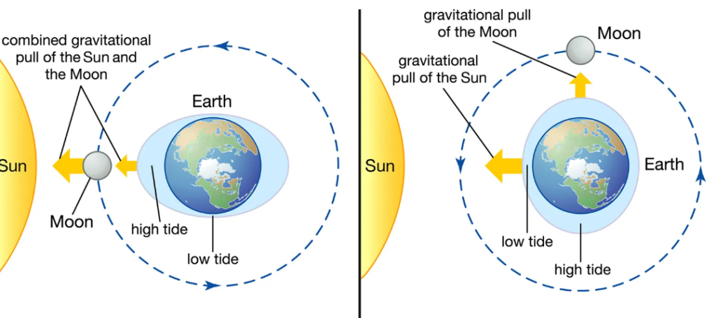
Spring Tide
A spring tide occurs when the Sun, Moon, and Earth are aligned in a straight line — a configuration called syzygy that happens during both the new moon and the full moon — causing the gravitational pulls of the Sun and Moon to combine and produce unusually high high tides and unusually low low tides. The term spring refers not to the season but to the way the tide seems to leap or spring forth, and spring tides occur approximately every two weeks throughout the year regardless of the calendar season.
Neap Tide
A neap tide occurs when the Sun and Moon are positioned at right angles relative to Earth, a configuration that happens during the first and third quarter phases of the Moon, causing their gravitational effects to partially cancel each other out and produce a smaller tidal range than average — high tides that are lower than usual and low tides that are higher than usual. Neap tides alternate with spring tides on a roughly two-week cycle, creating the regular pattern of larger and smaller tidal ranges observed at most coastal locations throughout each lunar month.
King Tide
A king tide is an informal term for an exceptionally high tide that occurs when several astronomical factors align to produce tidal ranges significantly larger than typical spring tides, often coinciding with the Moon’s closest approach to Earth in its elliptical orbit, known as perigee, combined with a spring tide alignment. King tides provide a preview of what will become more routine high-water levels as sea levels continue to rise due to climate change, making them an increasingly important focus of coastal monitoring and planning.
Perigean Spring Tide
A perigean spring tide occurs when a spring tide coincides with the Moon’s perigee — the point in its monthly orbit where it is closest to Earth — producing tidal ranges even larger than typical spring tides because the Moon’s gravitational pull is stronger at this closer distance. These tides occur several times a year and are of particular interest to coastal flood forecasters, as the combination of factors can push tidal levels to their highest annual values.
Apogean Neap Tide
An apogean neap tide occurs when a neap tide coincides with the Moon’s apogee — the point in its monthly orbit where it is farthest from Earth — producing the smallest tidal ranges of the lunar cycle because the already-diminished neap tide effect is further weakened by the Moon’s increased distance and correspondingly reduced gravitational pull. These tides represent the calmest tidal conditions that occur on a regular basis at most coastal locations.
Equatorial Tide
An equatorial tide occurs when the Moon is positioned directly above Earth’s equator during its monthly orbital cycle, producing tides of relatively similar magnitude at both high tides within a tidal day because the Moon’s gravitational influence is distributed more evenly across both hemispheres. This configuration tends to minimize the diurnal inequality — the difference in height between the two daily high tides — that is more pronounced when the Moon is positioned far from the equatorial plane.
Tropic Tide
A tropic tide occurs when the Moon reaches its maximum declination away from the equator — its furthest point north or south during its monthly cycle — causing one of the two daily high tides to become significantly higher than the other, a phenomenon known as diurnal inequality. Tropic tides are particularly pronounced in regions that already exhibit mixed tidal patterns, amplifying the difference between the higher high tide and lower high tide of each day.
Ebb Tide
An ebb tide refers to the period during which the tide is falling, as water flows away from the shore and sea levels decrease from high tide toward the following low tide. Ebb tides create strong seaward currents in estuaries, inlets, and river mouths, which mariners and fishing communities have long timed their activities around, as the outgoing current can either assist or hinder vessels depending on their direction of travel.
Flood Tide
A flood tide refers to the period during which the tide is rising, as water flows toward the shore and sea levels increase from low tide toward the following high tide. Flood tides bring nutrient-rich water and marine organisms into estuaries and coastal wetlands, supporting the productive ecosystems that depend on this regular tidal exchange, and they create landward currents that vessels can use to assist their passage into harbors and rivers.
Slack Tide
A slack tide is the brief period of time during which the tidal current momentarily stops moving as the tide transitions from ebbing to flooding or from flooding to ebbing, occurring twice during each tidal cycle at the moments of highest and lowest water. Slack tide periods are particularly important for activities like diving, fishing in certain conditions, and navigating narrow channels where strong tidal currents would otherwise make passage difficult or dangerous.
Storm Tide
A storm tide is the combined water level that results when the normal predicted tide is elevated by storm surge — the additional rise in sea level caused by the high winds and low atmospheric pressure of a storm system, particularly hurricanes and other intense coastal storms. Storm tides represent the actual water level experienced during a storm event and can be dramatically higher than either the predicted tide or the storm surge alone would suggest, making them one of the most dangerous aspects of coastal storm impacts.
Tidal Bore
A tidal bore is a phenomenon in which the leading edge of an incoming flood tide forms a distinct wave or series of waves that travel upstream against the current of a river, typically occurring in rivers with funnel-shaped estuaries that amplify tidal energy as it moves inland. Some of the world’s most famous tidal bores, including those on the Qiantang River in China and the Severn River in England, attract surfers and spectators who come to witness or ride these unusual upstream-traveling waves.
Internal Tide
An internal tide is a tidal oscillation that occurs beneath the ocean surface, at the boundary between layers of water with different densities, rather than at the surface itself. Internal tides can have amplitudes of tens to over a hundred meters within the ocean’s interior, playing an important role in mixing water masses of different temperatures and salinities and influencing the distribution of nutrients throughout the water column.
Meteorological Tide
A meteorological tide, sometimes called a weather tide, refers to changes in sea level driven primarily by atmospheric conditions — wind, air pressure, and weather systems — rather than by the gravitational forces that produce astronomical tides. Sustained onshore winds can push water toward the coast and elevate sea levels independently of the predicted astronomical tide, while high atmospheric pressure can suppress sea levels, and these effects combine with astronomical tides to produce the actual observed water level.
Atmospheric Tide
An atmospheric tide is a periodic oscillation in atmospheric pressure and density driven by the same gravitational forces that produce oceanic tides, as well as by the thermal effects of solar heating on the atmosphere throughout the day. While generally too subtle to notice in daily life, atmospheric tides have measurable effects on global weather patterns and have been studied as part of efforts to understand the broader system of periodic forces acting on Earth’s fluid envelopes.
Earth Tide
An earth tide, also called a solid earth tide, refers to the periodic deformation of Earth’s solid crust caused by the same gravitational forces from the Moon and Sun that produce ocean tides, causing the ground surface to rise and fall by small amounts — typically tens of centimeters — on the same tidal cycles as the oceans. Although imperceptible to human senses, earth tides are measurable with precise instruments and must be accounted for in fields such as geodesy, particle physics experiments, and high-precision surveying.
Tidal Wave (Misnomer for Tsunami)
The term tidal wave is commonly but incorrectly used to refer to tsunamis, which are actually caused by underwater earthquakes, volcanic eruptions, or landslides rather than by tidal forces, leading oceanographers to discourage the use of this term in favor of the more accurate tsunami. The confusion likely arose because tsunamis, like tides, can cause dramatic and sudden changes in coastal water levels, but the underlying physical mechanisms are entirely unrelated.
Macrotidal Range
A macrotidal range describes a coastal location where the difference between high tide and low tide exceeds approximately 4 meters, representing the largest category of tidal range classification. Locations with macrotidal ranges, such as the Bay of Fundy and parts of the Bristol Channel in the United Kingdom, experience dramatic transformations of their coastal landscapes between high and low tide, with vast areas of seabed exposed at low tide that are completely submerged just hours later.
Mesotidal Range
A mesotidal range describes a coastal location where the tidal range falls between approximately 2 and 4 meters, representing a moderate tidal classification common along many of the world’s coastlines. Mesotidal coasts often feature well-developed tidal flats, salt marshes, and barrier island systems shaped by the regular but not extreme exchange of water between high and low tide.
Microtidal Range
A microtidal range describes a coastal location where the tidal range is less than approximately 2 meters, representing the smallest category of tidal range classification and including many coastlines bordering relatively enclosed seas such as the Mediterranean and the Gulf of Mexico. Microtidal coasts tend to be more strongly shaped by wave action than by tidal currents, since the relatively small tidal exchange has less influence on coastal sediment transport compared to macrotidal and mesotidal environments.
Mixed Diurnal Tide
A mixed diurnal tide is a tidal pattern that predominantly resembles a diurnal pattern — one high and one low tide per day — but occasionally shows a brief secondary high or low tide during certain phases of the lunar cycle, particularly when the Moon’s declination is low. This pattern represents a transitional category between purely diurnal and mixed semidiurnal classifications, illustrating how tidal patterns exist along a continuum rather than in strictly separate categories.