Clouds are visible masses of condensed water droplets or ice crystals suspended in the atmosphere, forming when water vapor in the air cools and condenses around tiny particles of dust, salt, or other materials that serve as condensation nuclei. These formations play a fundamental role in Earth’s weather and climate systems, reflecting sunlight back into space, trapping heat radiated from the surface, and serving as the source of all precipitation that falls upon the planet. Clouds have captivated human observers throughout history, inspiring both scientific study and artistic and literary expression across virtually every culture.
The modern classification system for clouds was first developed in the early 19th century by the British naturalist Luke Howard, who introduced a Latin-based naming system that remains the foundation of cloud classification used by meteorologists worldwide today. Howard’s system organized clouds according to their general shape and appearance, using terms such as cumulus, meaning heap, stratus, meaning layer, and cirrus, meaning curl or wisp, which could be combined to describe more complex cloud forms. This elegant classification system has been expanded and refined over the subsequent two centuries but retains Howard’s original Latin terminology at its core.
Clouds are classified along two primary dimensions that together determine their appearance and behavior. The first dimension is altitude, with clouds divided into low, middle, and high categories based on the height of their base above the ground, a classification that correlates strongly with temperature and the physical processes occurring within the cloud. The second dimension is form, distinguishing between clouds that develop vertically through convective processes, producing the puffy, heap-like appearance of cumulus clouds, and clouds that form in flat, horizontal layers through more gradual processes, producing the sheet-like appearance of stratus clouds.
The combination of altitude and form categories produces the ten basic cloud types recognized by the World Meteorological Organization, along with numerous additional species and varieties that describe more specific cloud characteristics and unusual formations. Understanding the different types of clouds provides insight into current and developing weather conditions, as the presence, height, and movement of particular cloud types can indicate everything from fair weather to the approach of significant storms. The following overview explores the major cloud types and several notable special formations that occur under particular atmospheric conditions.
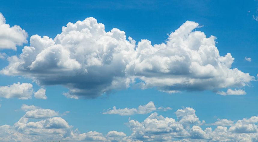
Cumulus
Cumulus clouds are puffy, white, cotton-like clouds with flat bases and rounded tops, forming through the upward convection of warm, moist air that cools and condenses as it rises. They are among the most recognizable and commonly observed cloud types, often associated with fair, pleasant weather.
These clouds typically form during the daytime as the sun heats the ground, creating columns of rising warm air that cool and condense at a characteristic altitude to produce the cloud’s flat base. While small cumulus clouds generally indicate stable weather conditions, larger cumulus clouds can develop into more significant storm clouds under the right atmospheric conditions.
Cumulonimbus
Cumulonimbus clouds are towering, anvil-shaped clouds that represent the most dramatic and potentially dangerous cloud type, capable of producing thunderstorms, heavy rainfall, hail, lightning, and even tornadoes. They can extend from relatively low altitudes up into the upper troposphere.
These massive clouds form when strong updrafts of warm, moist air rise rapidly through the atmosphere, often reaching altitudes where the cloud top spreads out into the characteristic flat, anvil-like shape as it encounters the stable air of the stratosphere. The intense vertical development within cumulonimbus clouds generates the powerful electrical charges responsible for lightning and the strong updrafts and downdrafts associated with severe weather.
Stratus
Stratus clouds are flat, gray, featureless layers that often cover large areas of sky, typically forming at relatively low altitudes and frequently associated with overcast, gloomy weather conditions. They can sometimes produce light precipitation in the form of drizzle.
These clouds form when a broad layer of air is lifted gradually or when air near the surface cools to the point of saturation, creating a relatively uniform layer without the distinct individual cloud elements seen in cumulus formations. Stratus clouds at ground level are essentially indistinguishable from fog, with the distinction depending primarily on whether the cloud base touches the surface.
Stratocumulus
Stratocumulus clouds form a layer of low, lumpy clouds that combine characteristics of both stratus and cumulus types, appearing as a relatively continuous sheet broken into distinct rounded masses or rolls. They typically occur at low altitudes and often cover extensive areas of sky.
These clouds form under conditions of weak convection occurring within a broader stratiform layer, creating the characteristic patchwork appearance that distinguishes them from the more uniform coverage of pure stratus clouds. Stratocumulus clouds generally indicate relatively stable weather conditions, though they can sometimes produce light precipitation.
Nimbostratus
Nimbostratus clouds are thick, dark, featureless layers that typically produce continuous, steady precipitation over extended periods, distinguishing them from the lighter drizzle sometimes associated with ordinary stratus clouds. They often extend across a substantial vertical range of the atmosphere.
These clouds form in association with large-scale weather systems, particularly warm fronts, where a broad area of rising air produces persistent precipitation that can last for many hours. The dense, extensive nature of nimbostratus clouds typically blocks sunlight almost entirely, creating the dark, gloomy conditions associated with prolonged rainy weather.
Cirrus
Cirrus clouds are thin, wispy, high-altitude clouds composed primarily of ice crystals, often appearing as delicate streaks or filaments across the sky that have earned them descriptions such as mare’s tails. They form at altitudes where temperatures are consistently below freezing.
These clouds typically indicate fair weather in the immediate term, though their presence can sometimes signal an approaching weather system several days in advance, as cirrus clouds often form ahead of warm fronts. The wispy appearance of cirrus clouds results from strong upper-level winds that stretch and shape the ice crystals into elongated streaks.
Cirrostratus
Cirrostratus clouds form a thin, translucent veil at high altitude that can cover large portions of the sky while remaining thin enough that the sun or moon remains visible through it, often creating a halo effect around these celestial bodies. The cloud layer can be difficult to detect except for this halo phenomenon.
These clouds are composed of ice crystals and often indicate an approaching weather system, particularly when they thicken and lower over a period of hours, signaling the advance of a warm front that may bring precipitation within a day or so. The halo effect created by cirrostratus clouds results from the refraction of light through the ice crystals composing the cloud.
Cirrocumulus
Cirrocumulus clouds appear as small, white patches or ripples at high altitude, often arranged in rows and composed primarily of ice crystals despite their cumulus-like appearance. Their patchy, textured appearance has led to descriptions such as mackerel sky due to their resemblance to fish scales.
These clouds form through limited convective processes occurring at high altitudes, creating the distinctive rippled or patchy pattern that distinguishes them from the smoother appearance of cirrostratus. Cirrocumulus clouds are relatively uncommon compared to other cirrus-family clouds and typically indicate generally fair but potentially changing weather conditions.
Altocumulus
Altocumulus clouds form a layer of grayish or whitish patches at middle altitudes, typically appearing as rounded masses or rolls arranged in groups, lines, or waves across the sky. They are among the most common mid-level cloud types observed.
These clouds form through convective processes occurring within a mid-level layer of the atmosphere, often developing ahead of approaching weather systems and sometimes indicating the potential for thunderstorm development later in the day if instability increases. The wave-like patterns sometimes visible in altocumulus clouds can result from atmospheric gravity waves moving through the cloud layer.
Altostratus
Altostratus clouds form a grayish or bluish layer at middle altitudes, typically covering large areas of sky and often thick enough to obscure the sun, though the sun may remain visible as a dim, diffuse glow through thinner portions. They lack the distinct cloud elements seen in altocumulus.
These clouds frequently form ahead of warm fronts, often developing from thickening cirrostratus as a weather system approaches, and can be a reliable indicator that precipitation is likely within the coming hours. Altostratus clouds can sometimes produce light precipitation themselves, particularly as they thicken and lower toward the surface.
Lenticular Clouds
Lenticular clouds are lens-shaped or saucer-shaped clouds that form, often in stationary positions, in association with airflow over mountains and other topographic obstacles that create wave patterns in the atmosphere. Their distinctive smooth, disc-like appearance has occasionally led to reports of unidentified flying objects.
These clouds form when moist air is forced to rise and fall in a wave pattern as it flows over and past a mountain or mountain range, with condensation occurring at the crest of each wave where the air cools sufficiently. Lenticular clouds can remain in essentially the same position for extended periods even as strong winds blow through them, since the cloud forms continuously on the windward side and dissipates on the leeward side of each wave crest.
Mammatus Clouds
Mammatus clouds are distinctive pouch-like or breast-shaped formations that hang from the underside of a cloud, most commonly associated with the trailing edges of severe thunderstorms. Their unusual, smooth, rounded protrusions create one of the more visually striking cloud formations observed in nature.
These formations are believed to result from sinking pockets of cold air within the cloud that descend into the warmer, drier air below, creating the rounded, pouch-like shapes through evaporation and condensation processes at the boundary between the two air masses. While their dramatic appearance can seem ominous, mammatus clouds typically appear after the most severe weather associated with a storm has already passed.
Pyrocumulus Clouds
Pyrocumulus clouds, sometimes called fire clouds, form above intense heat sources such as large wildfires or volcanic eruptions, developing through the same convective processes that create ordinary cumulus clouds but driven by the extreme heat rising from the fire or eruption rather than solar heating of the ground. They can grow to significant size under intense conditions.
In extreme cases, pyrocumulus clouds can develop into pyrocumulonimbus clouds, which produce their own lightning, strong winds, and even fire-generated tornadoes that can further spread and intensify the wildfire below. The study of these clouds has become increasingly important as larger and more intense wildfires have become more common in various regions of the world.
Noctilucent Clouds
Noctilucent clouds are extremely high-altitude clouds that form in the mesosphere, far higher than any other cloud type, becoming visible only after sunset when they are illuminated by sunlight from below the horizon while the lower atmosphere has already fallen into darkness. Their name means night-shining.
These clouds are composed of ice crystals that form at altitudes where temperatures are extremely cold and atmospheric pressure is a tiny fraction of that at the surface, conditions that exist primarily during summer months at high latitudes. Noctilucent clouds have become an area of scientific interest partly because their occurrence appears to have increased in recent decades, potentially linked to changes in atmospheric conditions associated with climate change.
Contrails
Contrails, short for condensation trails, are artificial cloud-like formations created by aircraft flying at high altitude, forming when hot, humid exhaust from jet engines mixes with cold ambient air and the water vapor condenses and freezes into ice crystals. They appear as linear streaks across the sky.
While contrails are not naturally occurring clouds, they can persist and spread under certain atmospheric conditions, sometimes developing into larger cloud formations that resemble natural cirrus clouds and that some research suggests may have a measurable effect on local weather and climate. The visibility and persistence of contrails depends significantly on the humidity and temperature of the atmosphere at the altitude where aircraft are flying.
Clouds are visible masses of condensed water droplets or ice crystals suspended in the atmosphere, forming when water vapor in the air cools and condenses around tiny particles of dust, salt, or other materials that serve as condensation nuclei. These formations play a fundamental role in Earth’s weather and climate systems, reflecting sunlight back into space, trapping heat radiated from the surface, and serving as the source of all precipitation that falls upon the planet. Clouds have captivated human observers throughout history, inspiring both scientific study and artistic and literary expression across virtually every culture.
The modern classification system for clouds was first developed in the early 19th century by the British naturalist Luke Howard, who introduced a Latin-based naming system that remains the foundation of cloud classification used by meteorologists worldwide today. Howard’s system organized clouds according to their general shape and appearance, using terms such as cumulus, meaning heap, stratus, meaning layer, and cirrus, meaning curl or wisp, which could be combined to describe more complex cloud forms. This elegant classification system has been expanded and refined over the subsequent two centuries but retains Howard’s original Latin terminology at its core.
Clouds are classified along two primary dimensions that together determine their appearance and behavior. The first dimension is altitude, with clouds divided into low, middle, and high categories based on the height of their base above the ground, a classification that correlates strongly with temperature and the physical processes occurring within the cloud. The second dimension is form, distinguishing between clouds that develop vertically through convective processes, producing the puffy, heap-like appearance of cumulus clouds, and clouds that form in flat, horizontal layers through more gradual processes, producing the sheet-like appearance of stratus clouds.
The combination of altitude and form categories produces the ten basic cloud types recognized by the World Meteorological Organization, along with numerous additional species and varieties that describe more specific cloud characteristics and unusual formations. Understanding the different types of clouds provides insight into current and developing weather conditions, as the presence, height, and movement of particular cloud types can indicate everything from fair weather to the approach of significant storms. The following overview explores the major cloud types and several notable special formations that occur under particular atmospheric conditions.
Cumulus
Cumulus clouds are puffy, white, cotton-like clouds with flat bases and rounded tops, forming through the upward convection of warm, moist air that cools and condenses as it rises. They are among the most recognizable and commonly observed cloud types, often associated with fair, pleasant weather.
These clouds typically form during the daytime as the sun heats the ground, creating columns of rising warm air that cool and condense at a characteristic altitude to produce the cloud’s flat base. While small cumulus clouds generally indicate stable weather conditions, larger cumulus clouds can develop into more significant storm clouds under the right atmospheric conditions.
Cumulonimbus
Cumulonimbus clouds are towering, anvil-shaped clouds that represent the most dramatic and potentially dangerous cloud type, capable of producing thunderstorms, heavy rainfall, hail, lightning, and even tornadoes. They can extend from relatively low altitudes up into the upper troposphere.
These massive clouds form when strong updrafts of warm, moist air rise rapidly through the atmosphere, often reaching altitudes where the cloud top spreads out into the characteristic flat, anvil-like shape as it encounters the stable air of the stratosphere. The intense vertical development within cumulonimbus clouds generates the powerful electrical charges responsible for lightning and the strong updrafts and downdrafts associated with severe weather.
Stratus
Stratus clouds are flat, gray, featureless layers that often cover large areas of sky, typically forming at relatively low altitudes and frequently associated with overcast, gloomy weather conditions. They can sometimes produce light precipitation in the form of drizzle.
These clouds form when a broad layer of air is lifted gradually or when air near the surface cools to the point of saturation, creating a relatively uniform layer without the distinct individual cloud elements seen in cumulus formations. Stratus clouds at ground level are essentially indistinguishable from fog, with the distinction depending primarily on whether the cloud base touches the surface.
Stratocumulus
Stratocumulus clouds form a layer of low, lumpy clouds that combine characteristics of both stratus and cumulus types, appearing as a relatively continuous sheet broken into distinct rounded masses or rolls. They typically occur at low altitudes and often cover extensive areas of sky.
These clouds form under conditions of weak convection occurring within a broader stratiform layer, creating the characteristic patchwork appearance that distinguishes them from the more uniform coverage of pure stratus clouds. Stratocumulus clouds generally indicate relatively stable weather conditions, though they can sometimes produce light precipitation.
Nimbostratus
Nimbostratus clouds are thick, dark, featureless layers that typically produce continuous, steady precipitation over extended periods, distinguishing them from the lighter drizzle sometimes associated with ordinary stratus clouds. They often extend across a substantial vertical range of the atmosphere.
These clouds form in association with large-scale weather systems, particularly warm fronts, where a broad area of rising air produces persistent precipitation that can last for many hours. The dense, extensive nature of nimbostratus clouds typically blocks sunlight almost entirely, creating the dark, gloomy conditions associated with prolonged rainy weather.
Cirrus
Cirrus clouds are thin, wispy, high-altitude clouds composed primarily of ice crystals, often appearing as delicate streaks or filaments across the sky that have earned them descriptions such as mare’s tails. They form at altitudes where temperatures are consistently below freezing.
These clouds typically indicate fair weather in the immediate term, though their presence can sometimes signal an approaching weather system several days in advance, as cirrus clouds often form ahead of warm fronts. The wispy appearance of cirrus clouds results from strong upper-level winds that stretch and shape the ice crystals into elongated streaks.
Cirrostratus
Cirrostratus clouds form a thin, translucent veil at high altitude that can cover large portions of the sky while remaining thin enough that the sun or moon remains visible through it, often creating a halo effect around these celestial bodies. The cloud layer can be difficult to detect except for this halo phenomenon.
These clouds are composed of ice crystals and often indicate an approaching weather system, particularly when they thicken and lower over a period of hours, signaling the advance of a warm front that may bring precipitation within a day or so. The halo effect created by cirrostratus clouds results from the refraction of light through the ice crystals composing the cloud.
Cirrocumulus
Cirrocumulus clouds appear as small, white patches or ripples at high altitude, often arranged in rows and composed primarily of ice crystals despite their cumulus-like appearance. Their patchy, textured appearance has led to descriptions such as mackerel sky due to their resemblance to fish scales.
These clouds form through limited convective processes occurring at high altitudes, creating the distinctive rippled or patchy pattern that distinguishes them from the smoother appearance of cirrostratus. Cirrocumulus clouds are relatively uncommon compared to other cirrus-family clouds and typically indicate generally fair but potentially changing weather conditions.
Altocumulus
Altocumulus clouds form a layer of grayish or whitish patches at middle altitudes, typically appearing as rounded masses or rolls arranged in groups, lines, or waves across the sky. They are among the most common mid-level cloud types observed.
These clouds form through convective processes occurring within a mid-level layer of the atmosphere, often developing ahead of approaching weather systems and sometimes indicating the potential for thunderstorm development later in the day if instability increases. The wave-like patterns sometimes visible in altocumulus clouds can result from atmospheric gravity waves moving through the cloud layer.
Altostratus
Altostratus clouds form a grayish or bluish layer at middle altitudes, typically covering large areas of sky and often thick enough to obscure the sun, though the sun may remain visible as a dim, diffuse glow through thinner portions. They lack the distinct cloud elements seen in altocumulus.
These clouds frequently form ahead of warm fronts, often developing from thickening cirrostratus as a weather system approaches, and can be a reliable indicator that precipitation is likely within the coming hours. Altostratus clouds can sometimes produce light precipitation themselves, particularly as they thicken and lower toward the surface.
Lenticular Clouds
Lenticular clouds are lens-shaped or saucer-shaped clouds that form, often in stationary positions, in association with airflow over mountains and other topographic obstacles that create wave patterns in the atmosphere. Their distinctive smooth, disc-like appearance has occasionally led to reports of unidentified flying objects.
These clouds form when moist air is forced to rise and fall in a wave pattern as it flows over and past a mountain or mountain range, with condensation occurring at the crest of each wave where the air cools sufficiently. Lenticular clouds can remain in essentially the same position for extended periods even as strong winds blow through them, since the cloud forms continuously on the windward side and dissipates on the leeward side of each wave crest.
Mammatus Clouds
Mammatus clouds are distinctive pouch-like or breast-shaped formations that hang from the underside of a cloud, most commonly associated with the trailing edges of severe thunderstorms. Their unusual, smooth, rounded protrusions create one of the more visually striking cloud formations observed in nature.
These formations are believed to result from sinking pockets of cold air within the cloud that descend into the warmer, drier air below, creating the rounded, pouch-like shapes through evaporation and condensation processes at the boundary between the two air masses. While their dramatic appearance can seem ominous, mammatus clouds typically appear after the most severe weather associated with a storm has already passed.
Pyrocumulus Clouds
Pyrocumulus clouds, sometimes called fire clouds, form above intense heat sources such as large wildfires or volcanic eruptions, developing through the same convective processes that create ordinary cumulus clouds but driven by the extreme heat rising from the fire or eruption rather than solar heating of the ground. They can grow to significant size under intense conditions.
In extreme cases, pyrocumulus clouds can develop into pyrocumulonimbus clouds, which produce their own lightning, strong winds, and even fire-generated tornadoes that can further spread and intensify the wildfire below. The study of these clouds has become increasingly important as larger and more intense wildfires have become more common in various regions of the world.
Noctilucent Clouds
Noctilucent clouds are extremely high-altitude clouds that form in the mesosphere, far higher than any other cloud type, becoming visible only after sunset when they are illuminated by sunlight from below the horizon while the lower atmosphere has already fallen into darkness. Their name means night-shining.
These clouds are composed of ice crystals that form at altitudes where temperatures are extremely cold and atmospheric pressure is a tiny fraction of that at the surface, conditions that exist primarily during summer months at high latitudes. Noctilucent clouds have become an area of scientific interest partly because their occurrence appears to have increased in recent decades, potentially linked to changes in atmospheric conditions associated with climate change.
Contrails
Contrails, short for condensation trails, are artificial cloud-like formations created by aircraft flying at high altitude, forming when hot, humid exhaust from jet engines mixes with cold ambient air and the water vapor condenses and freezes into ice crystals. They appear as linear streaks across the sky.
While contrails are not naturally occurring clouds, they can persist and spread under certain atmospheric conditions, sometimes developing into larger cloud formations that resemble natural cirrus clouds and that some research suggests may have a measurable effect on local weather and climate. The visibility and persistence of contrails depends significantly on the humidity and temperature of the atmosphere at the altitude where aircraft are flying.