Have you ever looked up at the sky and seen shapes that looked like animals, faces, or even castles floating high above you? Those amazing shapes are clouds, and they’re made of tiny droplets of water or little bits of ice floating way up in the air. Even though clouds look soft and fluffy like cotton, they’re actually made of billions and billions of tiny water droplets all clumped together!
Clouds form when warm air carrying water vapor (that’s water in the form of an invisible gas) rises up into the sky and starts to cool down. When the air gets cold enough, the water vapor turns into tiny droplets of liquid water or tiny crystals of ice, and when enough of these droplets bunch together, we can see them as a cloud. It’s a bit like how you can see your breath on a cold day!
Did you know that clouds can actually help us predict the weather? That’s right — by looking at the shape, color, and height of clouds, scientists (and even regular people who pay attention) can often guess whether it’s going to be sunny, rainy, or even stormy. Some clouds mean it’s going to be a beautiful day, while other clouds might mean you should grab your umbrella!
There are lots of different types of clouds, and each one has its own special name and its own special job. Some clouds are puffy like cotton balls, some are flat like blankets, and some are wispy like feathers. Let’s explore some of the coolest types of clouds you might see in the sky!
Cumulus Clouds — The Cotton Ball Clouds
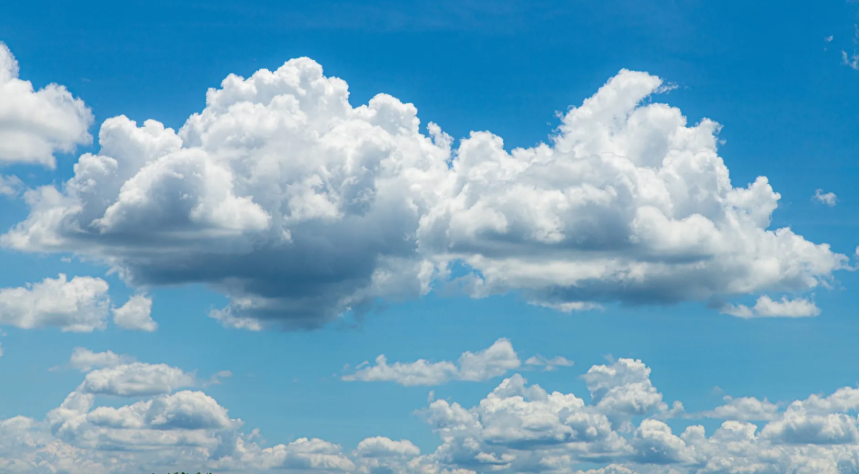
Cumulus clouds are the fluffy, white, puffy clouds that look like cotton balls or piles of whipped cream floating in the sky. These are probably the clouds you draw when you’re making a picture of a sunny day, because they usually show up when the weather is nice!
You’ll often see cumulus clouds on warm, sunny afternoons, drifting slowly across a bright blue sky. If you watch them for a while, you might even spot shapes that look like animals, dragons, or other fun things hiding in their puffy outlines!
Cumulonimbus Clouds — The Giant Storm Clouds
Cumulonimbus clouds are the biggest and most powerful clouds in the sky, growing so tall that they can look like giant towers or mushrooms reaching way up high. These are the clouds that bring thunderstorms, with loud thunder, bright lightning, and sometimes even hail!
If you see one of these huge, dark clouds building up in the sky, it might be a good idea to head inside, because a big storm could be on its way. The top of a cumulonimbus cloud sometimes spreads out flat, kind of like the top of an anvil, which is why people sometimes call it an anvil cloud.
Stratus Clouds — The Blanket Clouds
Stratus clouds are gray clouds that spread out flat across the whole sky, like a big blanket covering everything above you. When stratus clouds are around, the sky usually looks gloomy and gray, and the sun might be hard to see.
These clouds often bring light drizzle or a misty kind of rain, the gentle kind that makes everything feel a little damp. If a stratus cloud comes all the way down to the ground, it actually becomes fog, which is why foggy mornings can feel a bit like walking through a cloud!
Stratocumulus Clouds — The Lumpy Blanket Clouds
Stratocumulus clouds are a mix between the blanket-like stratus clouds and the puffy cumulus clouds, forming a layer of lumpy, bumpy clouds that cover a big part of the sky. They look a bit like a gray or white patchwork quilt up above you.
These clouds usually mean the weather is staying pretty calm, even if it’s a little cloudy outside. Sometimes you might see tiny gaps of blue sky peeking through between the lumps, like little windows in the cloud blanket.
Nimbostratus Clouds — The Rainy Day Clouds
Nimbostratus clouds are thick, dark gray clouds that cover the whole sky and bring steady rain that can last for a long time — sometimes all day! Unlike the light drizzle from stratus clouds, nimbostratus clouds bring real, proper rain.
When you see one of these big gray clouds taking over the sky, it’s a good day to find your raincoat, your umbrella, and maybe a fun indoor activity. These clouds don’t have any fluffy or bumpy shapes — they’re just one big, smooth, gray blanket of rain.
Cirrus Clouds — The Wispy Feather Clouds
Cirrus clouds are thin, wispy clouds that look like feathers, paintbrush strokes, or strands of hair stretched across a clear blue sky. They float very, very high up — much higher than most other clouds!
These clouds are made of tiny ice crystals instead of water droplets, because it’s so cold way up where they form. If you see cirrus clouds, the weather is usually nice for now, but they can sometimes be an early sign that the weather might change in a day or two.
Cirrostratus Clouds — The Halo Clouds
Cirrostratus clouds are thin, see-through clouds that spread across the sky like a sheer veil, so thin that you can usually still see the sun or moon shining through them. Sometimes they create a beautiful glowing ring, called a halo, around the sun or moon!
If you ever see a halo around the sun or moon, look closely and you might spot the thin cirrostratus clouds creating that magical effect. These clouds can sometimes mean that rainy weather might be coming within a day or so.
Cirrocumulus Clouds — The Fish Scale Clouds
Cirrocumulus clouds are made up of lots of tiny white puffs arranged in rows high up in the sky, creating a pattern that looks a bit like the scales on a fish or the wool on a sheep. People sometimes call this a mackerel sky because of how much it looks like fish scales!
These clouds are pretty rare compared to some other types, so spotting one can feel like finding a special pattern in the sky. They’re made of ice crystals, just like other high-up clouds, because it’s so cold at that height.
Altocumulus Clouds — The Sheep Clouds
Altocumulus clouds are made of grayish or white puffy patches that often look like a flock of sheep grazing across the sky, or sometimes like little rolls of cotton arranged in groups. They float at a medium height, lower than the wispy cirrus clouds but higher than the puffy cumulus clouds.
If you see these sheep-like clouds in the morning on a warm day, it could be a hint that thunderstorms might develop later in the afternoon. Either way, they’re fun to look at and great for spotting shapes!
Altostratus Clouds — The Gray Veil Clouds
Altostratus clouds form a grayish or bluish layer that covers a big part of the sky, often making the sun look dim and blurry, like looking at it through frosted glass. Unlike the halo-making cirrostratus clouds, you usually can’t see a clear halo through altostratus clouds.
These clouds often show up before a rainstorm arrives, so if the sky starts turning this hazy gray color, rain might be on its way soon. They’re not as dark and heavy as the rainy nimbostratus clouds, but they’re often a sign that those rain clouds aren’t far behind.
Lenticular Clouds — The UFO Clouds
Lenticular clouds are smooth, lens-shaped or saucer-shaped clouds that often form near mountains, and they look so much like flying saucers that people sometimes mistake them for UFOs! They can stay in the exact same spot in the sky for a long time, even when it’s windy.
These unusual clouds form when wind blows over a mountain and creates wavy patterns in the air, with the cloud forming at the top of each wave. If you’re ever near mountains and spot a strange, smooth, disc-shaped cloud just sitting there, you might be looking at a lenticular cloud!
Mammatus Clouds — The Bubble Wrap Clouds
Mammatus clouds have a really unusual look — they hang down from the bottom of a bigger cloud in rounded, pouchy shapes that look a bit like bubble wrap or a bunch of balloons all squished together. They’re one of the strangest-looking clouds you can see!
These bumpy clouds usually appear after a big thunderstorm, hanging from the back edge of the storm cloud as it moves away. Even though they can look a little scary because of their strange shape, mammatus clouds usually show up after the worst part of the storm has already passed.