Plains are among the most fundamental and far-reaching landforms on the surface of the Earth — vast, open expanses of relatively flat or gently undulating terrain that cover more of the planet’s land surface than any other landform type. Stretching across continents in sweeping horizons that seem to extend forever, plains lack the dramatic visual spectacle of mountains or the mysterious intimacy of caves, but they more than compensate with their sheer scale, their agricultural productivity, their ecological richness, and their profound influence on human civilization. Plains cover approximately 55 percent of the Earth’s land surface, making them by far the dominant landform of our planet.
The apparent simplicity of plains is deceptive. Beneath their flat or gently rolling surfaces lies an extraordinary diversity of geological histories, rock types, soil compositions, and formation processes. Some plains are built up by the patient accumulation of sediment — river-borne silt, wind-blown sand, glacial debris — deposited layer upon layer over millions of years. Others are the product of erosion, ancient mountain ranges and plateaus worn down by the relentless action of water, wind, and ice until only their flat foundations remain. Still others reflect the direct expression of geological structure — vast, stable blocks of ancient continental crust that have remained tectonically quiet for hundreds of millions of years, their surfaces planed flat by the long action of surface processes.
Plains have been the cradles and corridors of human civilization to a degree surpassed by no other landform. The great agricultural plains of the world — the North American Great Plains, the Eurasian Steppe, the Indo-Gangetic Plain, the Pampas of South America — produce the overwhelming majority of the world’s grain and support the bulk of its agricultural population. The flatness of plains has facilitated human movement, communication, and cultural exchange, allowing the spread of languages, religions, technologies, and peoples across vast distances with minimal topographic obstruction. The world’s great cities — from the ancient civilizations of Mesopotamia to the modern metropolises of the American Midwest — have overwhelmingly chosen plain environments for their development, drawn by fertile soils, navigable rivers, and the ease of construction and communication that flat terrain provides.
Alluvial Plains
Alluvial plains are formed by the long-term deposition of sediment — sand, silt, clay, and gravel — carried by rivers and streams and deposited as they slow down upon reaching flatter terrain. They are among the most fertile and agriculturally productive landforms on Earth, their deep, rich soils the accumulated product of millennia of sediment deposition from upstream catchments.
Alluvial plains develop in a variety of settings — at the foot of mountain ranges where rivers emerge onto flat lowlands and lose velocity, along the courses of mature rivers flowing across broad valleys, and in the lower reaches of river systems approaching the sea. The depth of alluvial deposits can be extraordinary — the alluvial fill of the Indo-Gangetic Plain reaches thicknesses of over 3,000 meters in places, representing tens of millions of years of sediment accumulation from the eroding Himalayas.
The Indo-Gangetic Plain of South Asia — stretching approximately 2,500 kilometers across Pakistan, India, and Bangladesh — is the world’s most extensive alluvial plain and one of the most densely populated regions on Earth, supporting over 1 billion people. The alluvial plains of the Yellow River in China, the Nile Valley in Egypt, and the Po Plain in northern Italy are other alluvial plains of exceptional agricultural and historical significance.
Coastal Plains
Coastal plains are low-lying, flat or gently sloping plains that border ocean coastlines, formed by the emergence of former shallow sea floors as sea levels fell or land was uplifted, or by the accumulation of marine and river sediments along the coast. They are typically narrow strips of flat terrain lying between the ocean and inland highlands or mountain ranges, gradually widening toward river mouths and delta regions.
The Atlantic Coastal Plain of the eastern United States is one of the world’s most extensive coastal plains, stretching approximately 3,200 kilometers from New York to the Gulf of Mexico and reaching widths of over 300 kilometers in the south. It was formed by the gradual emergence of shallow marine sediments as the Atlantic Ocean opened and sea levels fluctuated over the past 200 million years. The coastal plain continues offshore as the continental shelf, with the present coastline simply marking the current position of the sea.
Coastal plains are among the most economically valuable landforms on Earth — they provide flat, fertile land for agriculture and urban development, sheltered harbors and ports for maritime commerce, and access to both terrestrial and marine resources. However, their low elevation makes them highly vulnerable to sea level rise, storm surge, and coastal flooding — the coastal plains of Bangladesh, Vietnam’s Mekong Delta, and the US Gulf Coast face serious inundation threats from rising seas and intensifying tropical storms.
Flood Plains
Flood plains are flat, low-lying areas of land bordering rivers that are periodically inundated by floodwaters when the river overflows its banks during periods of high discharge. They are formed by the long-term deposition of fine sediment — silt and clay — carried in suspension by floodwaters and deposited as the water spreads out and slows down across the flat valley floor.
Flood plains are among the most fertile agricultural environments on Earth, their soils continuously enriched by fresh layers of nutrient-rich sediment deposited by each flood. The annual flooding of the Nile — which deposited a thin layer of rich silt across the Egyptian flood plain for thousands of years before the construction of the Aswan High Dam — was the foundation of one of history’s greatest civilizations. The Amazon flood plain — known as the várzea — covers approximately 300,000 square kilometers and is flooded to depths of up to 15 meters for several months each year.
Flood plains support extraordinarily rich and diverse ecological communities, with the alternating wet and dry phases of the annual flood cycle driving complex patterns of productivity and biological activity. The Pantanal of South America — the world’s largest tropical wetland, covering approximately 150,000 to 195,000 square kilometers across Brazil, Bolivia, and Paraguay — is essentially an enormous seasonal flood plain, its vast grasslands, forests, and waterways supporting one of the greatest concentrations of wildlife in the Americas.
Glacial Plains
Glacial plains are formed by the deposition of material carried and released by glaciers and ice sheets, creating flat or gently undulating landscapes of glacial sediments — till, outwash sands and gravels, and glacial lake deposits — that mantle the underlying bedrock over vast areas. They represent the legacy of past ice ages, recording the advance and retreat of continental ice sheets that covered much of the Northern Hemisphere as recently as 12,000 years ago.
The Great Plains of central North America are partly glacial in character — their northern portions were covered by the Laurentide Ice Sheet during the last Ice Age and are underlain by thick deposits of glacial till that were subsequently modified by wind and water erosion into the gently rolling plains of today. The plains of northern Europe — the North European Plain stretching from northern France across Germany, Poland, and into Russia — are extensively glaciated, their soils derived from glacial deposits left by successive Scandinavian ice sheets.
Glacial outwash plains — also known as sandurs in Iceland — are formed immediately beyond glacier margins, where meltwater rivers deposit thick layers of sorted sand and gravel in broad, flat sheets. Iceland’s Skeiðarársandur, one of the world’s largest active outwash plains at approximately 1,000 square kilometers, is periodically devastated by jökulhlaups — catastrophic glacial outburst floods — that spread enormous quantities of sediment across its surface.
Abyssal Plains
Abyssal plains are the vast, almost featureless flat expanses of the deep ocean floor, lying at depths of 3,000 to 6,000 meters and covering approximately 50 percent of the Earth’s total surface area — making them the single most extensive landform on the planet. They are formed by the gradual accumulation of fine sediment — the skeletal remains of microscopic marine organisms, wind-blown dust, and volcanic ash — that settles slowly through the water column and buries the irregular volcanic topography of the oceanic crust beneath a thick, smooth blanket.
The accumulation of sediment on abyssal plains is extraordinarily slow — typically 1 to 10 centimeters per thousand years — but over the hundreds of millions of years since the ocean basins formed, the sediment has accumulated to depths of hundreds to thousands of meters. The abyssal plains of the Atlantic Ocean are among the flattest surfaces on Earth, with relief of less than 3 meters across distances of hundreds of kilometers.
Despite their apparent lifelessness, abyssal plains support unique communities of organisms adapted to extreme pressure, permanent darkness, near-freezing temperatures, and very low food availability. They are also of growing economic interest — the manganese nodules and polymetallic crusts scattered across many abyssal plains contain significant concentrations of economically valuable metals including manganese, nickel, cobalt, and copper, making them a focus of deep-sea mining interest despite profound concerns about the ecological consequences of such exploitation.
Lava Plains
Lava plains, also known as volcanic plains or basaltic plains, are formed by the eruption of large volumes of low-viscosity basaltic lava that spread across the landscape in broad, thin sheets before cooling and solidifying into flat or gently undulating surfaces of dark volcanic rock. They are found on every continent and represent some of the largest individual volcanic features on Earth.
The Deccan Plateau of India — one of the world’s largest lava plains — was formed by a series of catastrophic volcanic eruptions approximately 66 million years ago that poured out an estimated 1 to 2 million cubic kilometers of basaltic lava, covering approximately 500,000 square kilometers of the Indian subcontinent to depths of up to 2,000 meters. These eruptions — whose timing coincides with the mass extinction that wiped out the dinosaurs — are considered a contributing factor in one of the greatest biological crises in Earth’s history.
The Columbia River Plateau of the northwestern United States covers approximately 160,000 square kilometers of Oregon, Washington, and Idaho, its surface formed by flood basalt eruptions between 6 and 17 million years ago. The Snake River Plain, cutting across southern Idaho, is another major lava plain, its relatively young surface dotted with cinder cones and lava fields still largely unweathered into productive soils. Iceland’s interior highlands are dominated by active lava plains being built up by ongoing volcanic eruptions.
Erosional Plains (Peneplains)
Erosional plains, also known as peneplains — from the Latin for “almost plain” — are formed by the long-term erosion of ancient mountain ranges and elevated terrain down to near-base-level, producing a gently undulating surface of very low relief that represents the end product of millions of years of denudation. The term was coined by American geologist William Morris Davis in 1889 to describe the theoretical ultimate stage in his cycle of erosion.
True peneplains are rare because the geological stability required for millions of years of erosion to reduce a landscape to near-flatness is exceptional — tectonic uplift, sea level change, and climatic variation typically interrupt the cycle before completion. However, ancient cratons — the stable cores of continents that have been tectonically quiet for hundreds of millions of years — preserve surfaces that approximate the peneplain ideal.
The shield landscapes of Canada, Scandinavia, Brazil, and central Africa are classic erosional plains developed on ancient Precambrian basement rocks. The Canadian Shield — covering approximately 8 million square kilometers — is one of the world’s largest erosional plains, its surface representing the deeply eroded roots of mountain ranges that were as high as the modern Himalayas over a billion years ago. The extraordinary flatness of parts of the Australian interior reflects similarly ancient erosional history on some of the world’s oldest and most stable continental crust.
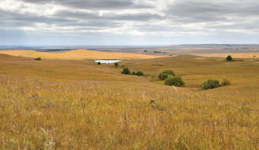
Steppe Plains
Steppe plains are vast, semi-arid to sub-humid grassland plains found in the interior of continents, characterized by a continental climate of hot summers, cold winters, and relatively low but seasonally concentrated rainfall sufficient to support a continuous grass cover but insufficient to sustain forest. They are among the world’s most extensive grassland ecosystems and have played a central role in human history as the highways of nomadic civilizations and the birthplace of horse domestication.
The Eurasian Steppe — the world’s largest continuous grassland plain — stretches approximately 8,000 kilometers from Hungary in the west across Ukraine, Russia, Kazakhstan, and Mongolia to Manchuria in the east, covering an area of approximately 5.5 million square kilometers. It formed the corridor along which successive waves of nomadic peoples — Scythians, Huns, Mongols, Turks — moved westward and eastward, shaping the history of both Europe and Asia. The Mongol Empire, the largest contiguous land empire in history, was made possible by the mobility afforded by the steppe and the horsemanship it developed.
The Great Plains of North America — covering approximately 1.3 million square kilometers across ten US states and three Canadian provinces — are the New World equivalent of the Eurasian Steppe, their native mixed-grass and shortgrass prairies once supporting an estimated 30 to 60 million bison before European settlement transformed them into the world’s most productive wheat and corn growing region.
Lacustrine Plains
Lacustrine plains are flat, low-lying plains formed by the accumulation of fine sediments deposited on the floors of ancient lakes that have since drained, dried up, or been significantly reduced in size. The quiet, still waters of lakes allow the finest particles of silt and clay to settle slowly to the bottom, building up thick, even layers of extraordinarily fine-grained sediment that produce exceptionally flat and fertile plains when the lake disappears.
The Red River Valley of the north — straddling the Minnesota-North Dakota border and extending into Manitoba, Canada — is one of the flattest landscapes on Earth, its surface the former floor of glacial Lake Agassiz, a vast lake that covered approximately 440,000 square kilometers of central North America at the end of the last Ice Age — larger than all of today’s Great Lakes combined. The valley floor is so flat that it drops only about 30 centimeters per kilometer across much of its width.
The Great Salt Lake in Utah is a remnant of the much larger glacial Lake Bonneville, whose former lake floor is now the Bonneville Salt Flats — a lacustrine plain of extraordinary flatness used as a land speed record venue since 1914. The Tarim Basin in western China contains thick lacustrine sediments from ancient lakes that once filled this enclosed depression. The lacustrine plains of the East African Rift Valley, formed by the shrinkage of ancient lake systems, are among Africa’s most fertile agricultural regions.
Desert Plains
Desert plains are arid or hyper-arid flat or gently undulating landscapes in which the dominant surface processes are wind erosion and deposition, occasional flash flooding, and the physical and chemical weathering of rock under extreme temperature fluctuations. They encompass several distinct subtypes — sandy ergs, stony regs, rocky hamadas, and salt flats — each reflecting a different balance of sediment supply, wind energy, and geological substrate.
The Sahara Desert contains all these desert plain subtypes across its 9.2 million square kilometers, from the vast sand seas of the Algerian and Libyan ergs — some with dunes exceeding 300 meters in height — to the flat, featureless gravel plains of the reg that cover approximately 70 percent of the Sahara’s total area. The hammada — bare rock plains from which all fine material has been stripped by wind — are among the most desolate landscapes on Earth.
The Rub’ al Khali — the Empty Quarter of the Arabian Peninsula — is the world’s largest continuous sand desert, covering approximately 650,000 square kilometers across Saudi Arabia, the UAE, Oman, and Yemen. Its sand plains reach depths of up to 200 meters in places. The Atacama Desert of Chile presents the opposite extreme — the world’s driest non-polar desert, its plains so desiccated that some areas have no recorded rainfall in their entire instrumental history.
Tidal Plains
Tidal plains, also known as tidal flats or intertidal plains, are low-lying coastal plains that are alternately submerged and exposed by the rise and fall of ocean tides, creating environments of extraordinary biological productivity that occupy the boundary between marine and terrestrial ecosystems. They are built up by the deposition of fine sediment — mud, silt, and clay — carried by tidal currents and deposited as the tidal flow slackens.
The Wadden Sea tidal plain along the coasts of the Netherlands, Germany, and Denmark is the world’s largest intertidal plain system, covering approximately 10,000 square kilometers and designated a UNESCO World Heritage Site. It supports millions of migratory birds that use it as a critical feeding and staging area along the East Atlantic Flyway, with some individual shorebird species nearly doubling their body weight in the Wadden Sea before making non-stop migratory flights of thousands of kilometers.
The Yellow Sea between China and Korea contains the world’s most extensive tidal mudflat system, with approximately 28,000 square kilometers of intertidal habitat — among the most productive marine ecosystems in the world in terms of benthic invertebrate biomass. The rapid reclamation of tidal plains for agriculture, aquaculture, and urban development in China and South Korea has destroyed an estimated 65 percent of the Yellow Sea’s tidal flats in recent decades, causing catastrophic declines in migratory shorebird populations.
Karst Plains (Poljes)
Karst plains are flat-floored depressions and plains developed in landscapes underlain by soluble rock — predominantly limestone and dolomite — where the dissolution of the bedrock by acidic groundwater has produced a distinctive suite of surface and subsurface landforms. The flat areas within karst landscapes are typically the floors of poljes — large enclosed depressions — or the residual plains between isolated limestone hills and towers.
The tower karst plains of southern China and Southeast Asia are among the world’s most visually extraordinary landscapes, their flat alluvial floors studded with hundreds of isolated limestone towers and pinnacles rising abruptly from the plain. The Li River plain near Guilin in Guangxi Province, China — perhaps the world’s most reproduced landscape image, its limestone karst towers reflected in the river — covers approximately 565 square kilometers and contains over 20,000 individual karst peaks.
The karst plains of the Yucatán Peninsula in Mexico are underlain by an extensive cave and sinkhole system — the world’s longest underwater cave system, with over 1,400 kilometers of mapped passages — that provides essentially all of the freshwater supply for the peninsula’s population of several million people. The Nullarbor Plain of southern Australia is a vast, flat karst plain underlain by limestone, its surface dotted with blowholes and cave entrances that connect to one of the world’s most extensive cave systems.