Islands have captured the human imagination since the earliest seafarers first ventured beyond the sight of the mainland and discovered land rising from the open ocean. Defined simply as bodies of land completely surrounded by water, islands are among the most diverse and ecologically remarkable features on the surface of the Earth, ranging from tiny uninhabited coral atolls barely a meter above sea level to vast landmasses like Greenland — covering 2.16 million square kilometers — that challenge the very distinction between island and continent. There are estimated to be over 900,000 islands in the world, though the precise number depends on the minimum size used to define an island as distinct from a rock or reef.
Islands have played a disproportionately significant role in the history of life on Earth. Because they are isolated from continental landmasses by stretches of open water, islands develop unique ecological communities shaped by the accidents of colonization — which species happened to arrive — and by the evolutionary pressures of isolation, which drive the development of species found nowhere else on the planet. The Galápagos Islands, the Hawaiian Islands, Madagascar, and New Zealand are among the world’s greatest laboratories of evolution, their endemic species — the creatures and plants found only on those islands — representing irreplaceable products of millions of years of isolated evolutionary history. Approximately 40 percent of the world’s most endangered species are found on islands, reflecting both their evolutionary uniqueness and their vulnerability to introduced predators and habitat destruction.
Islands have also been central to human history in ways far beyond their modest land areas. They served as stepping stones for the greatest maritime migrations in human history — the Polynesian settlement of the Pacific, the most extraordinary feat of open-ocean navigation ever accomplished, island-hopped across 10,000 kilometers of ocean to reach Hawaii, New Zealand, and Easter Island. Islands gave rise to some of history’s most powerful maritime empires — Britain, Japan, and Venice among them — and served as crucial waypoints in the global trade networks that connected the world’s civilizations. Today, islands are home to approximately 600 million people and face some of the most acute environmental challenges of the modern era, with low-lying island nations confronting existential threats from rising sea levels driven by climate change.
Continental Islands
Continental islands are fragments of continental landmasses that have become separated from the mainland by the flooding of low-lying land, tectonic rifting, or the gradual submergence of connecting land bridges. They sit on continental shelves and are geologically identical to the nearby mainland, composed of the same ancient rocks and sharing the same broad geological history.
Greenland, the world’s largest island at 2.16 million square kilometers, is a continental island — a fragment of the North American craton separated from the continent by the relatively shallow waters of Baffin Bay and the Davis Strait. The British Isles were connected to mainland Europe as recently as 8,000 years ago, when rising sea levels following the last Ice Age flooded the land bridge across what is now the North Sea and English Channel.
Continental islands typically have greater ecological complexity than oceanic islands because their biota reflects a long continental history rather than the filtered colonization of a newly formed oceanic island. Madagascar, which separated from Africa approximately 160 million years ago and from India approximately 88 million years ago, has evolved one of the world’s most extraordinary endemic faunas — approximately 90 percent of its wildlife is found nowhere else on Earth.
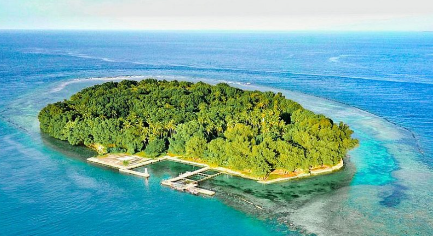
Oceanic Islands
Oceanic islands are islands that have risen directly from the deep ocean floor through volcanic activity, having never been connected to a continental landmass. They are entirely volcanic in origin and typically young in geological terms, their biological communities assembled entirely from species that colonized them by crossing open ocean — carried by wind, ocean currents, or their own powers of flight and swimming.
The Hawaiian Islands are the world’s most studied oceanic island chain, formed by the movement of the Pacific Plate over a stationary hotspot in the Earth’s mantle. The oldest of the main Hawaiian Islands, Kauai, is approximately 5 million years old, while the youngest, the Big Island of Hawaii, is still actively growing through ongoing volcanic eruptions. The chain extends further northwest as a series of older, eroded islands and atolls — the Emperor Seamount Chain — stretching 6,000 kilometers across the Pacific.
Because oceanic islands begin as bare volcanic rock with no pre-existing biota, every species present must have arrived by crossing the ocean. This filtering process means oceanic islands typically have far fewer species than equivalent areas of continental land, but those that do arrive and establish themselves often diversify dramatically into the available ecological niches — a process called adaptive radiation. Hawaii’s honeycreepers, which evolved from a single founding finch species into over 50 species with radically different bill shapes and feeding habits, are one of the most celebrated examples of island adaptive radiation.
Coral Islands
Coral islands are low-lying islands built entirely or primarily from coral reef material — the accumulated skeletal remains of coral polyps and associated organisms, cemented together and raised above sea level by a combination of biological growth, wave action, and changes in sea level. They are entirely biological in origin, built by living organisms rather than by geological or tectonic processes.
Coral islands are found exclusively in tropical and subtropical waters, between approximately 30 degrees north and south of the equator, where water temperatures are warm enough to support the coral growth on which they depend. The Maldives — an archipelago of 1,192 coral islands spread across approximately 90,000 square kilometers of the Indian Ocean — is the world’s lowest-lying nation, with an average elevation of just 1.5 meters above sea level, making it among the countries most immediately threatened by rising sea levels.
The Great Barrier Reef contains numerous coral islands known as cays — low, flat islands formed from coral sand and rubble deposited on reef platforms by wave action. Lady Elliot Island and Heron Island at the southern end of the Great Barrier Reef are classic coral cays, their surfaces stabilized by vegetation and supporting large seabird breeding colonies. Coral islands are geologically ephemeral features, constantly being reshaped by storms, biological activity, and changing sea levels.
Atolls
Atolls are a distinctive and remarkable type of coral island — ring-shaped or horseshoe-shaped coral reef structures enclosing a central lagoon, rising only slightly above sea level and often consisting of a chain of small coral islets rather than a single continuous landmass. They represent the final stage in the evolutionary sequence of coral reef development first described by Charles Darwin during his voyage on HMS Beagle in the 1830s.
Darwin proposed that atolls begin as fringing reefs around volcanic islands, gradually becoming barrier reefs as the volcanic island subsides, and finally becoming atolls as the volcano sinks entirely below the surface and only the coral reef — which continues to grow upward to maintain its position near the sea surface — remains. This theory was confirmed by drilling through Pacific atolls in the 20th century, revealing volcanic rock at depths of hundreds of meters beneath the coral.
The Pacific Ocean contains the vast majority of the world’s atolls — approximately 440 of the world’s estimated 440 atolls are found in the Pacific, with the Marshall Islands, Kiribati, Tuvalu, and the Maldives consisting almost entirely of atoll formations. Lifou Atoll in the Loyalty Islands is the world’s largest raised atoll, while Kiritimati — Christmas Island — in Kiribati is the world’s largest atoll by land area at approximately 388 square kilometers.
Barrier Islands
Barrier islands are long, narrow, low-lying sandy islands running parallel to the mainland coast and separated from it by a shallow lagoon or estuary. They are formed by the accumulation and redistribution of sand by wave action, longshore drift, and wind, and they serve as natural buffers protecting the mainland coast from the full force of ocean waves and storm surge.
The eastern and Gulf coasts of the United States have approximately 300 barrier islands extending for about 5,000 kilometers — one of the world’s most extensive barrier island systems. Notable examples include the Outer Banks of North Carolina, Padre Island in Texas — the world’s longest barrier island at 182 kilometers — and the sea islands of Georgia and South Carolina. Miami Beach and Galveston in Texas are built on barrier islands.
Barrier islands are among the most dynamic and rapidly changing landforms on Earth, migrating landward over time as sea levels rise and storm events push sand from the seaward face across the island to the lagoon side. The average barrier island on the US Atlantic coast migrates approximately 1.5 meters landward per year, a rate expected to accelerate significantly as sea level rise and storm intensity increase with climate change.
River Islands
River islands are bodies of land completely surrounded by the waters of a river, formed by the deposition of sediment within the river channel, the bifurcation of the channel around a resistant rock outcrop, or the cutoff of a meander bend. They range in size from tiny, temporary sand bars that appear and disappear with changing water levels to large, stable, permanently vegetated islands of considerable size.
Majuli Island in the Brahmaputra River in Assam, India, is the world’s largest river island, covering approximately 880 square kilometers — though its area has shrunk dramatically from over 1,200 square kilometers a century ago due to erosion, making it one of the world’s fastest-disappearing islands. Ilha do Bananal in the Araguaia River in Brazil, covering approximately 19,000 square kilometers, is sometimes cited as the world’s largest river island, though it is technically an island only during flood season.
River islands are often fertile and agriculturally productive because they are built from river sediments rich in nutrients. The islands of the Ganges Delta, the Nile Delta islands, and the numerous islands of the Amazon River system support dense agricultural populations. River islands are highly vulnerable to flooding and erosion, and many communities living on them face chronic risks from seasonal floods.
Artificial Islands
Artificial islands are landmasses created entirely or substantially by human construction rather than natural geological or biological processes, built in oceans, seas, rivers, and lakes for purposes including urban expansion, military strategy, transportation infrastructure, tourism, and environmental engineering. They represent some of the most ambitious engineering projects in human history.
The Palm Islands of Dubai — Palm Jumeirah, Palm Jebel Ali, and the under-construction Palm Deira — are the world’s most famous modern artificial islands, constructed from sand dredged from the Persian Gulf seabed. Palm Jumeirah alone required approximately 94 million cubic meters of sand and 7 million tons of rock and added approximately 560 kilometers of new coastline to Dubai. The World Islands project, also off Dubai, consists of approximately 300 artificial islands arranged in the shape of a world map.
Historically, artificial islands have a long heritage — the Aztec capital of Tenochtitlan, now Mexico City, was built on an artificial island in Lake Texcoco, and the Japanese island of Dejima in Nagasaki Harbor was constructed in 1636 as a trading post. Kansai International Airport near Osaka is built entirely on an artificial island in Osaka Bay, as is Hong Kong International Airport. The Netherlands has reclaimed approximately 17 percent of its current land area from the sea over several centuries of continuous engineering effort.
Tidal Islands
Tidal islands are landmasses connected to the mainland — or to another island — by a natural causeway, sandbar, or rock ridge that is submerged at high tide and exposed at low tide, creating an island that is accessible on foot for only part of each day. The rhythmic alternation between accessibility and isolation gives tidal islands a unique and mysterious character that has made many of them sites of profound cultural and spiritual significance.
Mont Saint-Michel off the coast of Normandy in France is the world’s most famous tidal island, its medieval abbey rising dramatically from a rocky outcrop that is surrounded by some of the highest tidal ranges in Europe — up to 14 meters. Approximately 3.5 million people visit Mont Saint-Michel annually, making it the most visited site in France outside Paris. Holy Island of Lindisfarne off the Northumberland coast of England, accessible by a causeway covered twice daily by tides, was the site of one of early medieval Europe’s most important Christian monasteries.
Tidal islands are found on coastlines with significant tidal ranges worldwide. Adam’s Bridge — also known as Rama’s Bridge — a chain of limestone shoals and sandbanks between India and Sri Lanka, is exposed at low tide to form a near-continuous land connection approximately 50 kilometers long, and holds deep significance in Hindu tradition.
Inland Islands
Inland islands are landmasses completely surrounded by freshwater rather than saltwater — islands in lakes, reservoirs, and large rivers. They range from tiny rocky outcrops barely above water level to substantial landmasses supporting large human populations, and they are found on every continent in environments ranging from tropical rainforest to Arctic tundra.
Lake Victoria in East Africa, the world’s largest tropical lake and the second largest freshwater lake by surface area at approximately 68,800 square kilometers, contains approximately 3,000 islands. The Ssese Islands, a group of 84 islands in the Ugandan sector of Lake Victoria, support a substantial fishing community. Lake Huron in North America contains Manitoulin Island — the world’s largest freshwater island at approximately 2,766 square kilometers — which itself contains several inland lakes with their own islands.
Titicaca Island — Isla del Sol — on Lake Titicaca on the Bolivia-Peru border, at 3,812 meters above sea level one of the world’s highest navigable lakes, is considered the birthplace of the Inca civilization according to traditional belief. The Floating Islands of the Uros people, constructed entirely from harvested totora reeds on the surface of Lake Titicaca, represent one of the world’s most extraordinary examples of human adaptation to island living.
Shelf Islands
Shelf islands are islands located on the continental shelf — the shallow, submerged extension of a continent that lies beneath water depths typically less than 200 meters. They may be continental in origin, composed of rocks continuous with the nearby mainland, or they may be the eroded remnants of ancient coastal features — hills, ridges, and plateaus — that were isolated by rising sea levels at the end of the last Ice Age.
The islands of the Indonesian archipelago — the world’s largest island group, consisting of over 17,000 islands — are predominantly shelf islands, sitting on the Sunda Shelf, the shallow continental platform that was largely exposed as dry land during glacial periods when sea levels were up to 120 meters lower than today. Java, Sumatra, Borneo, and Bali were all connected to mainland Southeast Asia as recently as 18,000 years ago.
The Faroe Islands between Norway and Iceland, the Channel Islands off the coast of Normandy, and the islands of the Gulf of Maine are all shelf islands. Shelf islands typically have greater ecological richness than truly oceanic islands because their proximity to continental landmasses allows more species to colonize them, and because they often share geological and biological histories with nearby mainland regions.
Volcanic Islands
Volcanic islands are islands formed entirely by volcanic activity, rising from the ocean floor through repeated eruptions that build up sufficient material to breach the ocean surface and create dry land. They are geologically young, geomorphologically dynamic, and often extraordinarily fertile — the weathering of volcanic rock produces exceptionally rich soils that support dense vegetation and intensive agriculture.
Iceland is the world’s largest active volcanic island, covering approximately 103,000 square kilometers and sitting directly on the Mid-Atlantic Ridge — the divergent plate boundary where the North American and Eurasian plates are pulling apart at approximately 2.5 centimeters per year. Iceland experiences approximately 20 to 30 volcanic eruptions per decade, and the island continues to grow as eruptions add new material to its surface. The 1963 eruption that created the island of Surtsey off Iceland’s southern coast — a new island that rose from the sea in a matter of days — was one of the most dramatic volcanic island formation events ever directly witnessed and documented by scientists.
The Canary Islands, the Azores, Réunion, and the Galápagos are all volcanic island groups of great scientific and ecological significance. The Big Island of Hawaii adds an estimated 90 metric tons of new volcanic material to its surface every minute during active eruption phases, making it the fastest-growing island on Earth.
Floating Islands
Floating islands are a remarkable and relatively rare phenomenon — masses of vegetation, peat, and organic material that have detached from shorelines or lake beds and float freely on the surface of lakes, rivers, or coastal lagoons, sometimes supporting complex plant communities, wildlife, and even human habitation. They move with wind and currents, sometimes traveling considerable distances from their points of origin.
Natural floating islands form in a variety of ways. In some lakes, mats of aquatic vegetation grow so densely that they accumulate sufficient buoyancy to detach from the bottom and float freely. In peatland environments, accumulations of peat can become waterlogged to the point where methane gas produced by decomposition provides enough buoyancy to lift sections of peat bog from the substrate. Floating islands are found across the world, from the reed islands of Lake Titicaca to the floating peat islands of the Amazon floodplain.
Loktak Lake in Manipur, India — the largest freshwater lake in northeastern India — contains the world’s largest natural floating islands, known as phumdis, which cover approximately 40 square kilometers of the lake surface. The Keibul Lamjao National Park, the world’s only floating national park, is established on these phumdis and is the last natural habitat of the endangered Sangai deer. In Myanmar’s Inle Lake, local farmers have developed a sophisticated system of artificial floating gardens — constructed from water hyacinth and lake mud — that have been used for centuries to grow vegetables and flowers.