Coastlines are among the most dynamic and constantly changing features of the Earth’s surface — the restless boundaries where the solid world of rock and soil meets the fluid, tireless energy of the ocean. Stretching for an estimated 620,000 kilometers around the world’s continents and islands, coastlines encompass an extraordinary range of environments, from towering vertical cliffs carved from ancient granite to low-lying mudflats barely distinguishable from the sea itself, from the coral-fringed shores of tropical islands to the ice-scoured coasts of polar regions. No two stretches of coastline are identical, and the variety of forms they take reflects the complex interplay of geology, sea level, wave energy, tidal range, climate, and biological processes that shape them.
The study of coastlines — their formation, classification, evolution, and management — falls within the field of coastal geomorphology, one of the most practically important branches of physical geography given that approximately 40 percent of the world’s population lives within 100 kilometers of a coast. Coastal environments support some of the world’s most productive ecosystems, including coral reefs, mangrove forests, salt marshes, and seagrass beds, which together provide habitat for an enormous proportion of marine biodiversity and deliver ecosystem services — fisheries, coastal protection, carbon storage, tourism — worth trillions of dollars annually. At the same time, coastlines are among the environments most vulnerable to the combined pressures of sea level rise, increased storm intensity, coastal development, and sediment supply disruption that characterize the current era of human-driven environmental change.
The classification of coastlines has occupied geographers and geologists since the early 20th century, with various systems proposed based on the dominant processes shaping them, their relationship to sea level change, their geological structure, or their biological character. Some coastlines are primary — shaped primarily by terrestrial processes such as river deposition, volcanic activity, or tectonic movement — while others are secondary, shaped predominantly by marine processes including wave erosion, longshore drift, and biological activity. Understanding this distinction, and the many subtypes within each broad category, is essential to predicting how coastlines will respond to the environmental changes of the coming decades.
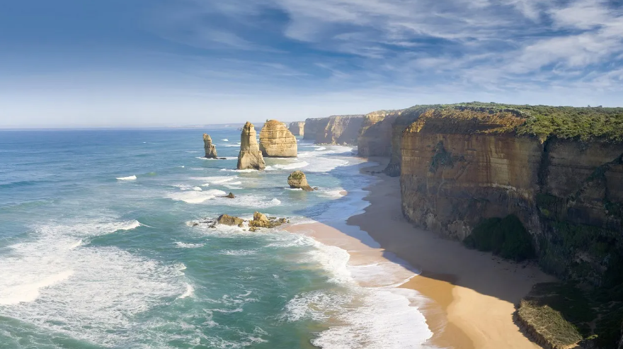
Cliffed Coastlines
Cliffed coastlines are formed where wave erosion attacks resistant rock along a steep or near-vertical shore, undercutting the base of the cliff and causing the face above to collapse, gradually retreating inland while maintaining its steep profile. They are among the most visually dramatic of all coastal landforms, their sheer rock faces exposing layer upon layer of geological history and providing nesting habitat for enormous seabird colonies.
The rate of cliff retreat varies enormously depending on rock type and wave energy. The chalk cliffs of the English Channel retreat at an average of 1 to 3 centimeters per year, while the soft glacial till cliffs of Holderness on the Yorkshire coast — the fastest eroding coastline in Europe — retreat at an average of nearly 2 meters per year, with some sections losing up to 10 meters in a single storm event.
The White Cliffs of Dover, rising up to 107 meters above the English Channel, and the Cliffs of Moher on the Atlantic coast of Ireland, reaching 214 meters at their highest point, are among the world’s most iconic cliffed coastlines. The Great Australian Bight presents one of the longest continuous cliff coastlines on Earth, with the Bunda Cliffs stretching approximately 210 kilometers along the southern edge of the Nullarbor Plain.
Fjord Coastlines
Fjord coastlines are among the most spectacular and dramatic coastal landscapes on Earth, formed where deeply glacially carved U-shaped valleys have been flooded by the sea following the retreat of the ice sheets at the end of the last Ice Age. The resulting coastlines are characterized by long, narrow, extremely deep inlets penetrating far inland, flanked by steep valley walls that often rise thousands of meters directly from the water.
Norway has the most extensive fjord coastline in the world — when all the indentations of its fjords are included, Norway’s total coastline length reaches approximately 25,000 kilometers despite the country spanning only about 1,750 kilometers from north to south in a straight line. Sognefjord, the world’s deepest fjord, reaches a depth of 1,308 meters and extends 204 kilometers inland.
Other significant fjord coastlines are found in Greenland, Iceland, Chile, New Zealand’s South Island, and the Pacific coast of Canada and Alaska. Fjord coastlines are renowned for their extraordinary scenery — the combination of mirror-still water, towering rock walls, hanging waterfalls, and the interplay of light and shadow creates landscapes of almost surreal beauty that attract millions of tourists annually.
Delta Coastlines
Delta coastlines form where rivers carrying large sediment loads deposit their material as they enter the sea, building up broad, low-lying plains of accumulated sediment that extend the coastline progressively seaward. They develop when the rate of sediment deposition exceeds the rate at which waves and currents remove it, allowing the river’s mouth to prograde — advance outward — into the sea.
The shape of a delta depends on the balance between river input, wave energy, and tidal range. River-dominated deltas like the Mississippi develop long, finger-like distributary channels extending into relatively calm water — the Mississippi Delta advances into the Gulf of Mexico at approximately 90 meters per year in some channels. Wave-dominated deltas are smoothed into arcuate forms by longshore drift, while tide-dominated deltas develop intricate networks of tidal channels penetrating far inland.
The Ganges-Brahmaputra Delta, covering approximately 105,000 square kilometers across Bangladesh and West Bengal, is the world’s largest delta and one of the most densely populated regions on Earth. The Niger Delta, the Amazon Delta, and the Mekong Delta are other major delta coastlines of global ecological and economic significance.
Ria Coastlines
Ria coastlines form when river valleys are partially drowned by a relative rise in sea level — either through the sinking of the land or the rising of the sea — creating long, funnel-shaped inlets that taper progressively inland and are open to the sea at their mouths. Unlike fjords, which are glacially carved and have steep, nearly vertical walls, rias are drowned river valleys with gentler, V-shaped cross-sections and gradually shallowing floors.
Ria coastlines are characterized by extraordinarily irregular outlines, with multiple long inlets separated by broad peninsulas, creating a deeply indented coastline of great complexity. The coast of Galicia in northwestern Spain — from which the term “ria” originates — presents a classic ria coastline, its four major rias providing sheltered deep-water harbors that have supported fishing and maritime commerce for centuries.
The southwestern coast of Ireland, the coast of Brittany in France, and parts of the coast of South Korea are other notable ria coastlines. Cornwall and Devon in southwest England display classic ria features, with drowned river valleys forming the harbors of Dartmouth, Fowey, and the Fal estuary. Ria coastlines typically offer excellent natural harbors and have historically been centers of maritime activity.
Beach and Barrier Coastlines
Beach and barrier coastlines are low-lying, sedimentary coastlines dominated by the accumulation and redistribution of sand and gravel by wave action, longshore drift, and wind, forming beaches, barrier islands, spits, and lagoons. They are among the most dynamic of all coastal environments, constantly changing shape as sediment is moved along and across the shore.
Barrier islands — long, narrow offshore sand bodies running parallel to the mainland and separated from it by shallow lagoons — are particularly characteristic of these coastlines. The eastern and Gulf coasts of the United States have approximately 300 barrier islands stretching for about 5,000 kilometers, protecting the mainland from direct wave attack and enclosing extensive lagoon and estuary systems of enormous ecological value.
The Outer Banks of North Carolina, the barrier islands of the Texas Gulf Coast, and the Lido di Venezia protecting the Venice Lagoon are classic barrier coastline features. Beach and barrier coastlines are particularly vulnerable to sea level rise and storm surge, and many are retreating landward at rates of 1 to 3 meters per year as sand supply diminishes and sea levels rise.
Mangrove Coastlines
Mangrove coastlines are found in tropical and subtropical regions where intertidal zones are colonized by mangrove trees — salt-tolerant woody plants that build up an extraordinary tangle of aerial roots capable of trapping sediment, stabilizing the shoreline, and creating habitat of exceptional biological richness. They are biological coastlines in the truest sense, shaped more by living organisms than by physical processes.
Mangroves cover approximately 137,000 square kilometers of coastline worldwide — roughly 15 percent of the world’s total coastline — concentrated in Southeast Asia, West Africa, South Asia, and the Caribbean. Indonesia alone accounts for approximately 23 percent of the world’s mangrove area. Mangrove forests provide coastal protection worth an estimated 65 billion dollars annually by reducing wave energy and storm surge, and they store carbon at rates up to four times higher than tropical rainforests per unit area.
The Sundarbans — the world’s largest mangrove forest, straddling the delta of the Ganges and Brahmaputra rivers across Bangladesh and India — covers approximately 10,000 square kilometers and supports one of the last remaining wild populations of the Bengal tiger. Mangrove coastlines are among the most threatened coastal environments on Earth, with approximately 35 percent of the world’s mangrove area having been lost since 1980 due to aquaculture, coastal development, and climate change.
Coral Reef Coastlines
Coral reef coastlines are tropical and subtropical coastlines fringed, protected, or defined by coral reef structures — living limestone formations built by colonies of coral polyps over thousands to millions of years. They are the most biologically diverse of all coastal environments and among the most structurally complex, the reef framework creating a mosaic of habitats that supports an extraordinary range of marine life.
Coral reefs cover approximately 284,000 square kilometers of ocean floor worldwide and are estimated to support approximately 25 percent of all marine species despite covering less than 1 percent of the ocean floor. The Great Barrier Reef off the coast of Queensland, Australia — the world’s largest coral reef system, stretching 2,300 kilometers and covering approximately 344,400 square kilometers — is the largest living structure on Earth and is visible from space.
Coral reef coastlines are critically threatened by ocean warming — coral bleaching events, in which elevated sea temperatures cause corals to expel their symbiotic algae and turn white, have affected over 50 percent of the Great Barrier Reef in major bleaching events since 2016. Ocean acidification, overfishing, coastal pollution, and physical destruction add to the pressures on these irreplaceable coastal ecosystems.
Volcanic Coastlines
Volcanic coastlines are formed by volcanic activity — either the direct outpouring of lava into the sea, building new land as it cools and solidifies, or the erosion of volcanic rock by wave action, producing distinctive coastal landforms quite different from those of sedimentary or metamorphic rock coastlines. They are among the most geologically young and rapidly changing of all coastal types.
Hawaii’s coastline is the world’s most active volcanic coastline, with lava from Kilauea Volcano periodically flowing directly into the Pacific Ocean and adding new land to the Big Island’s southeastern shore. The 2018 eruption of Kilauea added approximately 3.5 square kilometers of new land to Hawaii’s coastline. Iceland, the Azores, the Canary Islands, and the Galápagos all present significant volcanic coastlines.
Volcanic coastlines often feature dramatic landforms including sea cliffs of columnar basalt — the Giant’s Causeway in Northern Ireland and Fingal’s Cave in Scotland being the world’s most famous examples — black sand beaches formed from pulverized basaltic rock, lava arches, and blowholes. The contrast between black volcanic rock, white surf, and the vivid blues and greens of tropical water makes volcanic coastlines among the most visually striking in the world.
Tidal Flat Coastlines
Tidal flat coastlines, also known as mudflat or wadden coastlines, are low-lying, extremely gently sloping shores characterized by the alternating exposure and inundation of broad, flat expanses of fine sediment — mud, silt, and sand — with each tidal cycle. They develop in sheltered, low-energy coastal environments where wave action is minimal and tidal range is sufficient to expose large areas of the sea floor at low tide.
The Wadden Sea along the coasts of the Netherlands, Germany, and Denmark is the world’s largest tidal flat system, covering approximately 10,000 square kilometers and designated a UNESCO World Heritage Site. The Yellow Sea between China and Korea contains the world’s most extensive intertidal mudflats, covering an estimated 28,000 square kilometers — a critically important stopover for millions of migratory shorebirds traveling the East Asian-Australasian Flyway.
Despite their apparently featureless appearance, tidal flats are among the most biologically productive environments on Earth, their sediments packed with invertebrates — worms, molluscs, crustaceans — that support enormous populations of wading birds and waterfowl. They also play a significant role in coastal carbon storage, trapping organic material in their fine sediments.
Estuarine Coastlines
Estuarine coastlines are defined by the presence of estuaries — semi-enclosed coastal bodies of water where freshwater from rivers mixes with saltwater from the sea, creating brackish environments of complex and constantly shifting salinity gradients. They are among the most ecologically productive and economically valuable of all coastal environments.
The world has approximately 1,000 major estuaries, ranging from small river mouths to vast, complex systems like Chesapeake Bay on the US East Coast — the largest estuary in the United States, covering approximately 11,600 square kilometers — and the Rio de la Plata estuary between Argentina and Uruguay, the widest estuary in the world at approximately 220 kilometers across at its mouth.
Estuarine coastlines support fisheries of enormous value — approximately 75 percent of the commercial fish species on the US East Coast depend on estuaries for some part of their life cycle — and historically concentrated human settlement due to their combination of freshwater access, sheltered harbors, and productive fisheries. Rotterdam, London, New York, Shanghai, and Buenos Aires all developed at estuarine locations.
Ice Coastlines
Ice coastlines are found in polar and subpolar regions where the shoreline is dominated by glacial ice — either in the form of ice cliffs where glaciers or ice sheets terminate directly at the sea, ice shelves floating on the ocean surface, or sea ice that seasonally covers the shore and nearshore waters. They are the most geologically active coastlines on Earth in terms of rapid change, with ice cliffs calving enormous icebergs and ice shelves collapsing in dramatic disintegration events.
Antarctica has the world’s most extensive ice coastline, with approximately 75 percent of the continent’s perimeter fringed by floating ice shelves or grounded ice cliffs that terminate directly in the ocean. The Ross Ice Shelf, roughly the size of France, presents an ice cliff rising up to 50 meters above the ocean surface along a front approximately 800 kilometers long.
Ice coastlines are changing with extraordinary rapidity in response to climate change. The collapse of the Larsen B Ice Shelf in 2002 — 3,250 square kilometers of ice disintegrating in just 35 days — and the ongoing retreat of Greenland’s tidewater glaciers are among the most dramatic expressions of climate change visible anywhere on Earth. The retreat of Arctic sea ice is simultaneously opening new coastlines to wave erosion for the first time in millennia, dramatically accelerating coastal erosion across the Arctic.
Karst Coastlines
Karst coastlines develop where soluble limestone or dolomite rock meets the sea, combining the dissolution processes of karst landscape formation with the erosional and depositional processes of coastal geomorphology to produce some of the most visually extraordinary coastal landscapes on Earth.
The most dramatic karst coastlines feature towering limestone towers and pinnacles rising directly from the sea — the result of differential dissolution of the limestone along joints and fractures, leaving the most resistant rock standing as isolated spires. Ha Long Bay in Vietnam, containing approximately 1,600 limestone islands and islets rising dramatically from the Gulf of Tonkin, is the world’s most famous karst coastline and a UNESCO World Heritage Site.
The karst coastline of Phang Nga Bay in Thailand, the Palawan coast of the Philippines, and parts of the Adriatic coast of Croatia and Montenegro are other spectacular examples. Karst coastlines also feature sea caves of extraordinary development — the soluble rock is readily excavated by wave action along joint planes, producing large caves, arches, and tunnels — and anchialine pools connected to the sea through submerged cave passages in the rock.