Valleys are among the most fundamental and widespread landforms on the surface of the Earth, found on every continent, beneath every ocean, and across every climate zone from the tropics to the polar regions. They are defined broadly as elongated depressions in the Earth’s surface, typically lower than the surrounding terrain and often — though not always — drained by a river or stream running along their floor. Whether carved by the relentless grinding of ancient glaciers, cut by the patient work of flowing water over millions of years, or pulled open by the tectonic forces tearing the Earth’s crust apart, valleys are the product of some of the most powerful and persistent forces operating on our planet.
The sheer scale of the world’s valleys is staggering. The East African Rift Valley stretches over 6,000 kilometers from the Afar Triangle in Ethiopia to Mozambique in the south, making it one of the longest geological features on the surface of any planet in the solar system. The Yarlung Tsangpo Grand Canyon in Tibet — carved by the Yarlung Tsangpo River as it plunges off the Tibetan Plateau — reaches depths of over 5,300 meters, making it the deepest valley on Earth. The Amazon Valley drains a basin of approximately 7 million square kilometers, roughly the size of the entire continent of Australia. These figures speak to the enormous variety and grandeur that the category of “valley” encompasses.
Valleys are not merely passive features of the landscape — they are dynamic environments that have shaped human history in profound ways. The world’s earliest civilizations arose in river valleys: the Nile Valley in Egypt, the Tigris-Euphrates Valley in Mesopotamia, the Indus Valley in South Asia, and the Yellow River Valley in China all cradled the first cities, the first writing systems, and the first complex agricultural societies. Today, valleys continue to concentrate human settlement, agriculture, and economic activity, with an estimated 80 percent of the world’s population living in lowland areas that include valley floors and floodplains. Understanding the different types of valleys is therefore not just a matter of academic geography but an insight into the physical foundations of human civilization itself.
V-Shaped Valleys
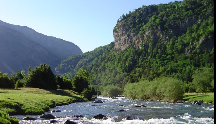
V-shaped valleys are the most common type of river valley, formed by the continuous downward cutting of a river or stream through the underlying rock over long periods of time. As the river erodes its bed deeper and deeper, the valley walls are simultaneously weathered and worn back by rain, frost action, and mass wasting, producing the characteristic V-shaped cross-section that gives this valley type its name. V-shaped valleys are most typical in upland and mountainous regions where rivers are young and energetic, with steep gradients that give them the power to cut rapidly downward. The gorges of the Himalayan foothills, the steep-sided valleys of the Welsh uplands, and many of the river canyons of the American West display classic V-shaped profiles.
U-Shaped Valleys (Glacial Troughs)
U-shaped valleys are carved by glaciers rather than rivers, and their broad, flat floors and steep, nearly vertical walls give them a profile strikingly different from the V-shaped valleys created by water erosion. A glacier is an immensely powerful erosional agent, grinding away not just the floor of a valley but its sides as well, widening and deepening the original river valley it occupies into a broad trough. When the glacier retreats, it leaves behind a dramatically transformed landscape. Glacial troughs can reach extraordinary dimensions — Sognefjord in Norway, one of the world’s longest fjords and a classic U-shaped valley, stretches 204 kilometers inland and reaches a depth of 1,308 meters. Yosemite Valley in California, carved by glaciers during the Pleistocene Ice Age, is perhaps the most famous U-shaped valley in the world.
Rift Valleys
Rift valleys are formed not by erosion but by the pulling apart of the Earth’s crust along divergent tectonic plate boundaries. As the crust is stretched and thinned by tensional forces, a central block drops down between two parallel fault lines, creating an elongated depression flanked by steep escarpments. Rift valleys are among the largest and most geologically significant landforms on Earth. The East African Rift Valley, extending over 6,000 kilometers and containing some of the world’s deepest lakes — including Lake Tanganyika at 1,470 meters deep — is the most dramatic example. The Rhine Rift Valley in Europe, the Baikal Rift Zone in Siberia, and the Rio Grande Rift in the American Southwest are other notable examples of this tectonic valley type.
Hanging Valleys
Hanging valleys are tributary valleys whose floors are significantly higher than the floor of the main valley they join, creating an abrupt step or drop at the junction. They form most commonly in glaciated landscapes where a large glacier occupying a main valley erodes its floor far more deeply than the smaller glaciers occupying the side valleys. When the ice retreats, the tributary valleys are left “hanging” high above the main trough, and any rivers or streams draining them plunge down to the main valley floor as waterfalls. Yosemite Valley is famous for its hanging valleys — Bridalveil Fall and Yosemite Falls both cascade from hanging valleys high above the valley floor, with Yosemite Falls dropping a total of 739 meters in three stages.
Canyon Valleys
Canyons are deep, steep-sided valleys carved by rivers cutting through arid or semi-arid landscapes where the walls are too dry to weather back and widen the valley significantly. The result is a valley that is dramatically deep relative to its width, with near-vertical rock walls exposing layer upon layer of geological history. The Grand Canyon in Arizona is the world’s most famous canyon, stretching 446 kilometers long, up to 29 kilometers wide, and reaching a depth of 1,857 meters — exposing nearly 2 billion years of Earth’s geological history in its walls. Canyons are found on every continent, with particularly spectacular examples in the American Southwest, the Himalayas, Ethiopia’s Blue Nile Gorge, and the Yarlung Tsangpo Canyon in Tibet.
Flat-Floored Valleys
Flat-floored valleys develop when a river valley that was once V-shaped gradually fills with sediment deposited by the river and its floodwaters over thousands of years. As the river loses energy on gentler gradients, it deposits the sediment it carries, slowly building up the valley floor into a broad, flat plain. These valleys are agriculturally among the most productive landforms on Earth because the accumulated alluvial sediments are exceptionally fertile. The Po Valley in northern Italy, stretching approximately 400 kilometers from the Alps to the Adriatic Sea, is one of Europe’s most agriculturally productive regions and a classic example of a flat-floored valley. Many of the world’s great agricultural civilizations developed on the flat floors of ancient alluvial valleys.
Fjords
Fjords are long, narrow, deep coastal inlets formed when glaciers carved U-shaped valleys that were subsequently flooded by the sea as sea levels rose following the retreat of the ice. They are characterized by their extraordinary depth — often much deeper inland than at the mouth, where a submerged threshold called a sill marks the farthest advance of the glacier — and by their steep, dramatic walls. Norway has approximately 1,190 named fjords and is considered the world’s premier fjord landscape, with its coastline extended to an extraordinary 25,000 kilometers when all the fjord indentations are included. Sognefjord, Hardangerfjord, and Geirangerfjord are among the most celebrated. Chile, New Zealand, Canada, and Greenland also have extensive fjord coastlines.
Box Valleys
Box valleys have flat floors and very steep, nearly vertical walls, giving them a rectangular or box-like cross-section. They typically form in arid environments where the valley walls are resistant to weathering and erosion, allowing them to remain near-vertical while the valley floor is widened by lateral erosion and partially filled with sediment. Box valleys are common in the canyon country of the American Southwest and in parts of southern Africa and central Australia. Their combination of flat, accessible floors and protective walls has made them historically attractive locations for human settlement and agriculture in otherwise challenging desert environments.
Blind Valleys
Blind valleys are valleys that end abruptly against a steep rock face or cliff, with no apparent outlet for the river or stream that drains them. They are most commonly found in karst landscapes — regions underlain by soluble limestone rock — where the stream draining the valley disappears underground through a swallow hole or cave entrance at the base of the terminal cliff rather than flowing out through a surface outlet. The sudden disappearance of rivers into the ground in blind valleys can be a dramatic phenomenon, and the underground cave systems that receive these rivers are often among the most extensive and complex in the world. Parts of Slovenia, the Dinaric Alps, and the Yucatán Peninsula of Mexico are rich in blind valley landscapes.
Hollow or Dell Valleys
Hollows and dells are small, sheltered, bowl-shaped or elongated depressions in the landscape, typically found in hilly or rolling terrain rather than in dramatic mountain settings. They are gentle, intimate landscape features — often wooded, frequently spring-fed, and characterized by a sense of enclosure and shelter from the wider landscape. Hollows form through a combination of soil creep, surface wash, and small-scale fluvial erosion concentrated in topographic low points. They are common across the temperate landscapes of western Europe and the eastern United States, and they have traditionally been favored locations for small rural settlements, mills, and farmsteads because of their reliable water supply and sheltered microclimate.
Rift Lake Valleys
Rift lake valleys are elongated depressions associated with rift tectonics that have been partially or wholly filled with water, creating some of the world’s deepest and most ancient lakes. The African Great Lakes — including Lake Tanganyika, Lake Malawi, and Lake Albert — occupy rift valley depressions and together contain approximately 25 percent of the world’s surface freshwater. Lake Baikal in Siberia, the world’s deepest lake at 1,642 meters, occupies the Baikal Rift Zone and contains an estimated 20 percent of the world’s unfrozen surface freshwater — more than all of North America’s Great Lakes combined. These rift lake valleys are extraordinary biodiversity hotspots, with Lake Tanganyika alone harboring over 350 species of cichlid fish found nowhere else on Earth.
Alluvial Valleys
Alluvial valleys are broad, gently sloping valleys whose floors are composed primarily of alluvium — sediments deposited by rivers and streams including sand, silt, clay, and gravel. They form when rivers lose velocity and deposit their sediment load, gradually building up a thick layer of fertile material across the valley floor. Alluvial valleys are among the most agriculturally valuable landforms on Earth, and the great alluvial plains of Asia — including the Ganges-Brahmaputra Valley, the Yangtze Valley, and the Mekong Valley — support some of the world’s highest rural population densities. The Nile Valley’s narrow ribbon of alluvial land, rarely more than a few kilometers wide in Upper Egypt, has supported one of history’s most enduring civilizations for over 5,000 years.
Gorges
Gorges are narrow, deep valleys with nearly vertical walls, essentially the extreme end of the canyon spectrum. They form where rivers cut rapidly downward through hard rock without significant widening, typically in tectonically active regions where the land is being uplifted at the same time as the river cuts downward, allowing the river to maintain its steep gradient. Some of the world’s most dramatic gorges are found where major rivers cross or are antecedent to rising mountain ranges. The Yarlung Tsangpo Gorge in Tibet, often cited as the world’s deepest gorge at over 5,300 meters from rim to river, was carved by the Yarlung Tsangpo River as the Himalayas rose around it. The Tiger Leaping Gorge on the Yangtze River in Yunnan, China, drops 3,900 meters over a distance of just 15 kilometers.
Tectonic Valleys
Tectonic valleys are formed primarily by the movement of tectonic plates rather than by erosion alone. They include rift valleys formed by crustal extension, but also valleys created by compressional tectonics, strike-slip faulting, and other tectonic processes that displace and deform the Earth’s crust. The Dead Sea Valley, part of the Dead Sea Transform fault system, is a tectonic valley that has dropped to the lowest point on Earth’s surface — the Dead Sea itself sits at approximately 430 meters below sea level. The Jordan Valley, of which the Dead Sea forms the terminal basin, is a classic tectonic depression created by transform faulting along the boundary between the African and Arabian plates.
Karst Valleys
Karst valleys form in landscapes underlain by soluble rock — most commonly limestone — where chemical weathering by slightly acidic rainwater dissolves the rock over time, creating a distinctive suite of landforms including sinkholes, caves, and dry valleys. Karst valleys often lack surface drainage because water drains away rapidly through cracks and caves in the underlying limestone rather than flowing along the surface. Dry valleys in chalk and limestone landscapes, poljes — large flat-floored karst depressions — and the spectacular tower karst valleys of southern China and Southeast Asia are all expressions of karst valley development. The Li River Valley in Guangxi, China, with its iconic limestone towers rising from the valley floor, is perhaps the world’s most photographed karst landscape.
Poljes
A polje is a large, flat-floored depression found in karst landscapes, typically elongated and enclosed by steep rocky walls, with a floor that may be intermittently flooded. Poljes are among the largest karst landforms, sometimes stretching for tens of kilometers. They form through a combination of dissolution of the underlying limestone and structural controls such as faults and fractures. The Livanjsko Polje in Bosnia and Herzegovina, one of the largest in the world, covers approximately 405 square kilometers. Poljes are often partially filled with terra rossa — a red clayey soil resistant to dissolution — and are used for agriculture during dry periods, though seasonal flooding can inundate them for months at a time.
Anticlinal and Synclinal Valleys
In folded mountain terrain, valleys do not always form in the obvious positions. An anticlinal valley forms along the crest of an anticline — an upward fold of rock — where the tension and fracturing of the rock at the fold’s apex makes it vulnerable to erosion, so the highest structural point becomes the lowest topographic point over time. Conversely, a synclinal mountain can develop where the compressed rock at the core of a downward fold is actually more resistant to erosion. These inverted relationships between geological structure and topographic expression are known as relief inversion and are well documented in the Appalachian Mountains and the Jura Mountains of Switzerland, where anticlines have been eroded into valleys while synclines stand as ridges.
Intermont Valleys
Intermont valleys, also called intermontane valleys or intermontane basins, are broad valleys or basins enclosed on multiple sides by mountain ranges. They are formed through a combination of tectonic subsidence, where the basin floor drops relative to the surrounding mountains, and the accumulation of sediment eroded from the surrounding peaks. The Central Valley of California, stretching approximately 720 kilometers between the Sierra Nevada and the Coast Ranges, is one of the most productive agricultural regions in the world, generating an estimated 25 percent of the food grown in the United States. The Kathmandu Valley in Nepal, the Kashmir Valley in India, and the Fergana Valley in Central Asia are other notable intermontane basins.
Dry Valleys
Dry valleys are valleys that lack a permanent or even seasonal stream, despite having been clearly carved by flowing water in the past. They are found in a variety of settings: in chalk and limestone landscapes where permeable rock allows water to drain underground rather than flow on the surface; in desert regions where rainfall is too sparse to maintain surface streams; and in formerly glaciated areas where meltwater channels were abandoned when the ice retreated. The Channeled Scablands of Washington State contain some of the world’s most dramatic dry valleys, carved catastrophically by massive floods released from glacial Lake Missoula during the last Ice Age — floods estimated to have discharged at rates up to ten times the combined flow of all the world’s rivers today.
Shoulder Valleys
Shoulder valleys, sometimes called alp valleys or bench valleys, develop on the sides of glacially carved mountain valleys at elevations well above the main valley floor. They represent the remnants of pre-glacial valley systems that were left stranded at higher elevations when the main glacier carved its trough far deeper than the tributary valleys. The broad, gently sloping shelves — known as alp benches or valley shoulders — that characterize many Alpine landscapes in Switzerland, Austria, and Norway are classic shoulder valley remnants. These elevated terraces are often used as summer pasture for livestock in traditional Alpine farming systems, and many of the famous “alp” meadows of the Swiss Alps occupy such shoulder valley positions.
Wind Gaps
Wind gaps are dry, low passes through ridges or mountain ranges that were originally carved by rivers but are no longer occupied by flowing water. They form when a river is captured by another drainage system — a process known as stream piracy — causing the original valley to be abandoned and left as a dry notch in the ridge. Wind gaps are common in the Ridge and Valley province of the Appalachian Mountains, where complex drainage history has left numerous dry gaps through the parallel ridges. They are historically significant as natural transportation corridors, and many of the earliest roads and railways crossing mountain ranges in the eastern United States were routed through wind gaps.
Submarine Valleys (Submarine Canyons)
Submarine valleys are elongated depressions on the ocean floor, including submarine canyons that cut deeply into the continental shelf and slope. Some are direct seaward extensions of river valleys, carved when sea levels were lower and rivers flowed across the exposed continental shelf to the sea’s edge. Others are formed by turbidity currents — dense, sediment-laden flows that rush down the continental slope with enough energy to carve deep channels in the seafloor. The Monterey Canyon off the coast of California is comparable in scale to the Grand Canyon, reaching a depth of approximately 3,600 meters. Hudson Canyon, extending 750 kilometers from the mouth of the Hudson River to the deep ocean floor, is one of the largest submarine canyons in the Atlantic Ocean.
Antecedent Valleys
Antecedent valleys are formed when a river maintains its original course across a landscape that is being uplifted by tectonic forces, cutting downward through the rising rock at the same rate as the land is being raised. The result is a river that appears to flow illogically through mountain ranges rather than around them, cutting dramatic gorges through obstacles that younger rivers would simply go around. The rivers draining the southern slopes of the Himalayas — including the Indus, the Ganges, and the Brahmaputra — are classic antecedent rivers, having established their courses before the Himalayas rose to their present height and maintaining those courses as the mountains rose around them over the past 50 million years.
Consequent and Subsequent Valleys
Consequent valleys are those whose drainage pattern directly follows the original slope of the land surface, flowing in the direction determined by the initial topography. Subsequent valleys, by contrast, develop along lines of structural weakness — fault zones, soft rock bands, and fractures — exploited by streams that erode laterally along these zones rather than following the original slope. The interplay between consequent and subsequent drainage over millions of years produces the complex, hierarchical valley systems of mature landscapes. The longitudinal valleys running parallel to the Appalachian ridges are classic subsequent valleys, carved along weak rock bands between the resistant ridges, while the rivers crossing the ridges through water gaps follow their original consequent courses.
Glacial Meltwater Valleys (Proglacial Valleys)
Glacial meltwater valleys, also known as proglacial valleys or meltwater channels, were carved by the enormous volumes of water released from melting glaciers during and after the last Ice Age. These channels are often far larger than any present-day river could carve, testifying to the prodigious volumes of meltwater that flowed across the landscape as the ice sheets retreated. Many of them are now partially or entirely dry, their original meltwater rivers long since diminished or redirected. The Finger Lakes of New York State occupy proglacial meltwater valleys deepened and modified by glacial action. The overflow channels of the Baltic Ice Lake, which drained across what is now northern Germany and Poland as the Scandinavian Ice Sheet melted, left behind a series of broad, flat-floored valleys known as Urstromtäler — ancient river valleys — that still influence the drainage pattern of northern Europe today.