A storm is any disturbed state of the atmosphere characterized by strong winds, heavy precipitation, or other severe weather conditions that disrupt normal atmospheric patterns and can pose significant hazards to people, property, and the natural environment. Storms occur at vastly different scales, from small, localized thunderstorms that affect a single town for an hour to massive hurricanes spanning hundreds of kilometers and lasting for days. Despite this enormous range in scale and character, all storms share a common underlying cause — the release of energy stored within the atmosphere, typically in the form of heat and moisture, through the rapid movement and reorganization of air masses.
The energy that drives storms ultimately comes from the sun, which heats the Earth’s surface unevenly across different latitudes, seasons, and times of day, creating temperature differences that drive the movement of air masses. When warm, moist air rises and encounters cooler air, the resulting instability can release enormous amounts of energy as water vapor condenses into liquid or ice, a process that releases what meteorologists call latent heat. This released energy can fuel further uplift and intensification, creating the feedback loops that allow storms to grow from modest beginnings into powerful weather systems.
Storms are responsible for both some of the most beneficial and some of the most destructive weather phenomena experienced anywhere on Earth. The same thunderstorms that bring life-giving rain to agricultural regions can also produce damaging hail, flooding, and tornadoes. Hurricanes and typhoons, while devastating to the coastal areas they strike, also play important roles in redistributing heat from the tropics toward higher latitudes and in maintaining the broader patterns of global atmospheric circulation. Understanding the formation, behavior, and hazards associated with different storm types is essential for forecasting, public safety, and disaster preparedness around the world.
The classification of storms encompasses a wide range of distinct phenomena, organized by the scale at which they occur, the specific atmospheric conditions that produce them, and the particular hazards they generate. From the localized violence of a tornado to the continental-scale impact of a winter blizzard, each storm type has its own characteristic formation process, geographic distribution, and seasonal pattern. The following overview explores the major types of storms recognized by meteorologists and the distinct atmospheric processes that bring each one into being.
Thunderstorms
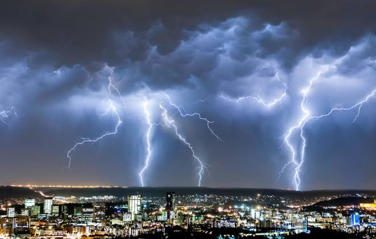
A thunderstorm is a localized storm characterized by lightning and the thunder it produces, typically accompanied by heavy rain, gusty winds, and sometimes hail, forming when warm, moist air rises rapidly and becomes unstable. Thunderstorms are among the most common storm types worldwide, occurring on every continent except Antarctica.
The basic ingredients required for thunderstorm formation include sufficient moisture in the lower atmosphere, instability that allows air to continue rising once it begins, and a triggering mechanism such as a front or heating that initiates the upward motion. While most thunderstorms are relatively brief, lasting perhaps thirty minutes to an hour, they can produce intense localized rainfall, dangerous lightning strikes, and in some cases the conditions necessary for more severe weather phenomena to develop.
Supercell Thunderstorms
A supercell thunderstorm is a particularly powerful and long-lived type of thunderstorm characterized by a persistent, rotating updraft known as a mesocyclone, distinguishing it from the more common single-cell and multi-cell thunderstorm varieties. Supercells are responsible for the majority of significant tornadoes and the largest hail.
The rotating updraft within a supercell can persist for hours, allowing the storm to maintain its intensity over a much longer period and travel much greater distances than ordinary thunderstorms. This rotation develops when wind shear — a change in wind speed or direction with height — tilts a horizontally rotating tube of air into a vertical orientation within the developing storm.
Tornadoes
A tornado is a violently rotating column of air that extends from a thunderstorm to the ground, capable of producing some of the strongest winds found anywhere on Earth’s surface within a very narrow and often short-lived path of destruction. Tornadoes vary enormously in size, intensity, and duration.
Most tornadoes form in association with supercell thunderstorms, developing when the rotating mesocyclone within the storm tightens and intensifies near the ground, though weaker tornadoes can also form through other mechanisms associated with less organized storms. The United States experiences more tornadoes than any other country in the world, particularly within the region known as Tornado Alley in the central plains, though tornadoes occur on every continent except Antarctica.
Hurricanes
A hurricane is an intense tropical cyclone that forms over warm ocean waters, characterized by a well-defined circular structure with a calm central eye surrounded by a ring of intense thunderstorms called the eyewall. Hurricanes are known by different names in different regions, including typhoons in the western Pacific and cyclones in the Indian Ocean.
These massive storm systems draw their energy from the heat and moisture of warm tropical ocean waters, requiring sea surface temperatures of at least 26 degrees Celsius to form and intensify, which is why hurricanes typically develop during the warmer months in tropical and subtropical regions. The destructive impact of hurricanes comes not only from their powerful winds but also from the storm surge they push ashore and the torrential rainfall that can cause widespread flooding far inland from the coast.
Tropical Storms
A tropical storm represents an earlier or weaker stage of tropical cyclone development, with sustained winds that are strong enough to cause damage but have not yet reached the threshold required to be classified as a hurricane or typhoon. Tropical storms can intensify into hurricanes or weaken and dissipate depending on atmospheric conditions.
The classification of a tropical cyclone as a tropical storm rather than a hurricane depends on its maximum sustained wind speed, with the specific threshold varying slightly between different national weather agencies around the world. Even without reaching hurricane intensity, tropical storms can produce significant rainfall and flooding, particularly when they move slowly or stall over a region for an extended period.
Blizzards
A blizzard is a severe winter storm characterized by a combination of strong winds, typically at least 35 miles per hour, and falling or blowing snow that reduces visibility to less than a quarter mile for an extended period. The combination of wind and snow is what distinguishes a blizzard from ordinary heavy snowfall.
The blowing and drifting snow associated with blizzards can create extremely hazardous travel conditions, with whiteout conditions making it nearly impossible to see even short distances and creating significant risks for anyone caught outdoors. Blizzards typically form in association with strong winter storm systems where cold air, moisture, and powerful pressure gradients combine to produce the sustained strong winds necessary for blizzard conditions.
Ice Storms
An ice storm is a winter weather event characterized by significant accumulations of freezing rain, which coats surfaces with a layer of clear ice that can become extremely heavy and damaging. Ice storms occur when a layer of below-freezing air near the surface underlies a layer of warmer air aloft where precipitation forms as rain.
The weight of ice accumulated during a significant ice storm can cause widespread damage to trees and power infrastructure, with branches snapping under the added weight and power lines coming down across entire regions, sometimes leaving residents without electricity for days or even weeks. Ice storms create particularly hazardous travel conditions, as even a thin layer of ice on roads can make driving extremely dangerous.
Dust Storms
A dust storm is a meteorological phenomenon characterized by strong winds lifting large quantities of dust, sand, or other fine particles into the air, dramatically reducing visibility and air quality over the affected area. Dust storms are most common in arid and semi-arid regions where loose, dry soil is readily available to be lifted by wind.
These storms can form when strong winds associated with thunderstorm outflows or larger weather systems sweep across dry, exposed land, picking up enormous quantities of particulate material that can travel significant distances before settling. Dust storms pose hazards to transportation due to reduced visibility, to respiratory health for people exposed to high concentrations of airborne particles, and to agriculture through the removal of valuable topsoil.
Sandstorms
A sandstorm is similar to a dust storm but involves the transport of larger, heavier sand particles that are typically lifted only a short distance above the ground, creating a dense, low-lying cloud of moving sand. Sandstorms are particularly common in desert regions with extensive areas of loose sand.
The larger size of sand particles compared to dust means that sandstorms typically affect a more limited vertical extent close to the ground, though the dense concentration of sand within this layer can still dramatically reduce visibility and create hazardous conditions for anyone caught in the open. Sandstorms can cause significant erosion of exposed surfaces and can bury roads, vehicles, and structures under accumulated sand if they persist for extended periods.
Derechos
A derecho is a widespread, long-lived windstorm associated with a fast-moving line of severe thunderstorms, producing damaging straight-line winds over a path that can extend for hundreds of kilometers. The term derecho comes from the Spanish word for straight, distinguishing the straight-line wind damage from the rotational damage caused by tornadoes.
For a windstorm to be officially classified as a derecho, it must produce wind damage along a swath at least 400 kilometers long with wind gusts of at least 93 kilometers per hour along most of its length, criteria that make derechos relatively rare but capable of causing damage comparable to a hurricane across a wide inland area. These storms typically form along the leading edge of a line of intense thunderstorms during the warmer months, often associated with a strong area of low pressure and significant atmospheric instability.
Nor’easters
A nor’easter is a powerful storm system that affects the eastern coast of North America, named for the northeasterly winds that blow onshore ahead of the storm as it moves up the coast, typically bringing heavy snow, rain, and strong winds to the affected region. These storms are most common during the late fall through early spring months.
Nor’easters form when a low-pressure system develops along the boundary between cold air over land and warmer air over the ocean, intensifying as it draws energy from this temperature contrast while moving northeastward along the coast. These storms can produce significant coastal flooding in addition to heavy precipitation, as their strong onshore winds push ocean water toward the coast.
Squalls
A squall is a sudden, sharp increase in wind speed that typically lasts only a few minutes, often accompanied by a brief period of rain, snow, or other precipitation, associated with the passage of a localized weather disturbance. Squalls can occur in isolation or as part of a larger storm system.
The sudden and often unexpected nature of squalls makes them particularly hazardous for activities such as sailing, where a calm sea can be transformed within minutes by a squall’s arrival into dangerous conditions with strong, gusty winds and reduced visibility. Squall lines, which consist of a series of thunderstorms arranged in a line, can produce a sequence of squalls as the line passes over a given location.
Snow Squalls
A snow squall is a brief but intense burst of heavy snowfall accompanied by strong winds, creating a sudden and dramatic reduction in visibility that can catch travelers off guard due to its rapid onset and short duration. Snow squalls are distinct from more prolonged winter storms in their brief, intense nature.
These events can be particularly dangerous on roadways, as drivers may encounter clear conditions just moments before a snow squall reduces visibility to nearly zero, creating a high risk of multi-vehicle accidents on highways. Snow squalls typically pass through a given location in a matter of minutes, with conditions often improving rapidly once the squall has moved on, though the brief period of intense snow and wind can cause significant hazards during its passage.
Hailstorms
A hailstorm is a thunderstorm that produces significant amounts of hail, the balls or irregular lumps of ice that form within the powerful updrafts of strong thunderstorms. While many thunderstorms produce at least some hail, the term hailstorm typically refers to events where hail accumulation or hail size is significant enough to cause notable impacts.
Severe hailstorms can cause substantial damage to crops, vehicles, roofing, and other property, with the largest hailstones capable of breaking windows and causing injury to people caught outdoors. The formation of large, damaging hail requires particularly strong and persistent updrafts, conditions that are most commonly found within supercell thunderstorms.
Microbursts
A microburst is a small but intense downdraft of air that descends rapidly from a thunderstorm and spreads out upon hitting the ground, creating strong, damaging winds over a relatively small area. Microbursts can produce wind speeds comparable to those of a tornado but with straight-line rather than rotational characteristics.
These intense downdrafts pose a particular hazard to aviation, as the sudden change in wind direction and speed associated with a microburst can be extremely dangerous for aircraft during takeoff or landing, leading to the development of specialized detection systems at many airports. Microbursts can occur with little advance warning and dissipate quickly, making them difficult to predict and forecast even with modern weather radar technology.
Polar Vortex Outbreaks
A polar vortex outbreak occurs when the large-scale circulation pattern that normally confines extremely cold air to polar regions weakens or shifts, allowing this cold air to surge southward into middle latitudes and bring exceptionally cold temperatures to regions that do not normally experience such extreme cold. This is a large-scale atmospheric pattern rather than a single storm in the traditional sense.
While the polar vortex itself is a persistent feature of the atmosphere that exists year-round, disruptions to its normal pattern can allow segments of extremely cold polar air to break away and travel toward lower latitudes, often in association with significant winter storm systems. These outbreaks can bring record-breaking cold temperatures to affected regions, creating dangerous conditions including frostbite and hypothermia risks alongside any accompanying snow or ice.