Wind is the movement of air from areas of high atmospheric pressure to areas of low atmospheric pressure, a fundamental process that occurs at every scale of the atmosphere, from gentle breezes that rustle leaves to powerful jet streams that circle the planet at high altitude. Wind plays an essential role in distributing heat and moisture around the globe, shaping weather patterns, influencing ocean currents, and affecting virtually every aspect of life on Earth, from the migration patterns of birds to the design of buildings and the routes taken by ships and aircraft. Without wind, the temperature differences between different regions of the planet would be far more extreme than they currently are.
The fundamental cause of all wind is the uneven heating of the Earth’s surface by the sun, which creates temperature differences between different locations, and these temperature differences in turn create differences in atmospheric pressure, since warmer air tends to be less dense and exert lower pressure than cooler, denser air. Air naturally moves from areas of higher pressure toward areas of lower pressure in an attempt to equalize these differences, and this movement of air is what we experience as wind. The greater the pressure difference between two locations, and the closer together those locations are, the stronger the resulting wind will be.
While the basic physics underlying all wind is the same, winds occur at vastly different scales and are influenced by a wide range of additional factors beyond simple pressure differences. The rotation of the Earth, through a phenomenon known as the Coriolis effect, deflects moving air to the right in the Northern Hemisphere and to the left in the Southern Hemisphere, creating the large-scale circulation patterns that dominate global wind systems. Local topography, the presence of water bodies, and the daily cycle of heating and cooling all contribute to creating winds that operate on much smaller scales than the global circulation patterns.
Understanding the different types of winds that occur on Earth provides insight into weather patterns, climate, and the countless ways that moving air shapes the environment around us. From the great global wind belts that have guided sailors for centuries to the local breezes that develop along coastlines and in mountain valleys, each type of wind has its own characteristic causes, patterns, and effects. The following overview explores the major categories of winds found on Earth, organized by the scale at which they occur and the specific processes that generate them.
Trade Winds
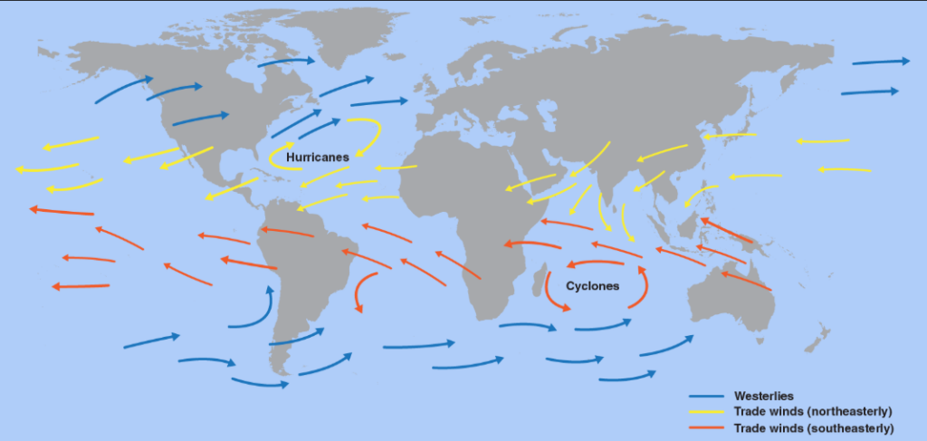
Trade winds are persistent winds that blow from the northeast in the Northern Hemisphere and from the southeast in the Southern Hemisphere, converging near the equator and forming one of the most consistent and predictable wind patterns on the planet. These winds were named for their historical importance to sailing ships engaged in trade across the oceans.
The trade winds form as part of the larger global circulation pattern driven by the intense heating of air near the equator, which rises and eventually descends at higher latitudes before flowing back toward the equator near the surface, with the Coriolis effect deflecting this flow into the characteristic northeasterly and southeasterly directions. For centuries, sailing vessels relied on the trade winds to make ocean crossings, with entire trade routes designed around the predictable patterns these winds provided.
Westerlies
Westerlies are persistent winds that blow from west to east in the middle latitudes of both hemispheres, roughly between 30 and 60 degrees latitude, forming another major component of the global wind circulation pattern. These winds are generally stronger and more variable than the trade winds.
The westerlies form as part of the circulation pattern that develops between the warm air rising near the equator and the cold air found at the poles, with the Coriolis effect deflecting this flow into a predominantly west-to-east direction at these latitudes. Sailing ships traveling from west to east across the Atlantic and Pacific Oceans historically took advantage of the westerlies, while ships traveling in the opposite direction had to find alternative routes to avoid sailing directly against these prevailing winds.
Polar Easterlies
Polar easterlies are cold, dry winds that blow from the east to west near the poles, forming the third major belt of prevailing winds in the global circulation pattern alongside the trade winds and westerlies. These winds occur at the highest latitudes in both hemispheres.
The polar easterlies form as cold, dense air sinks at the poles and flows outward toward lower latitudes, with the Coriolis effect deflecting this flow into an easterly direction at these high latitudes. These winds are generally weaker and less consistent than the trade winds and westerlies, partly due to the complex and variable nature of polar air masses and the influence of topographic features in polar regions.
Jet Streams
Jet streams are narrow bands of extremely strong winds that flow from west to east at high altitudes within the atmosphere, typically found near the boundary between the troposphere and the stratosphere where strong temperature contrasts create powerful pressure gradients. Wind speeds within jet streams can exceed 250 miles per hour.
These high-altitude wind currents have a significant influence on weather patterns at the surface, as they help steer the movement of weather systems including storms and fronts across continents and oceans. Commercial aircraft routes are often planned to take advantage of jet streams when flying in the same direction as the wind, significantly reducing flight times, while flights traveling against the jet stream must contend with increased headwinds and longer travel times.
Monsoon Winds
Monsoon winds are seasonal wind patterns that reverse direction between summer and winter, most famously associated with South Asia, where they bring distinct wet and dry seasons that have profound effects on agriculture and daily life for billions of people. The term monsoon derives from an Arabic word related to season.
These seasonal wind reversals occur because of the different rates at which land and ocean surfaces heat and cool throughout the year, with land heating more quickly in summer and creating a low-pressure area that draws moist air inland from the ocean, while the reverse pattern develops during winter. The arrival and intensity of monsoon rains can have enormous consequences for agricultural regions that depend on this seasonal precipitation, with both delayed monsoons and unusually intense monsoon rainfall capable of causing significant hardship.
Sea Breezes
A sea breeze is a local wind that blows from the sea toward the land during the day, developing because land surfaces heat up more quickly than water surfaces under the same sunlight, creating a temperature difference that drives air movement. Sea breezes are most noticeable on warm, sunny days near coastlines.
As the land heats up faster than the adjacent sea during the day, the air above the land becomes warmer and less dense, rising and creating a zone of lower pressure that draws cooler air in from over the water to replace it. This process creates the refreshing cooling breeze that people living near coastlines often experience during the afternoon hours, providing welcome relief from the heat of a summer day.
Land Breezes
A land breeze is the nighttime counterpart to the sea breeze, blowing from the land toward the sea as the land cools more quickly than the water after sunset, reversing the temperature difference that drove the daytime sea breeze. Land breezes are generally weaker than sea breezes.
As the land surface loses heat rapidly after sunset while the sea retains its warmth longer due to water’s higher heat capacity, the air over the land becomes cooler and denser than the air over the sea, creating a pressure difference that drives air from the land out toward the water. Fishing communities have historically taken advantage of land breezes to help sailing vessels depart from shore in the early morning hours before the sea breeze develops later in the day.
Mountain and Valley Winds
Mountain and valley winds are local wind patterns that develop in mountainous terrain due to the differential heating and cooling of slopes and valley floors, creating winds that blow up mountain slopes during the day and down into valleys at night. These local circulation patterns can be quite pronounced in areas with significant topographic relief.
During the day, mountain slopes heat up more quickly than valley floors, creating rising air along the slopes that draws air upward from the valley below, a pattern known as a valley breeze. At night, this pattern reverses as the slopes cool more rapidly than the valley floor, creating a downslope flow of cooler, denser air known as a mountain breeze, which can sometimes pool in valley bottoms and create notably cold conditions at lower elevations.
Katabatic Winds
A katabatic wind is a downslope wind caused by the gravitational flow of cold, dense air from higher elevations to lower elevations, occurring when air at higher altitudes cools significantly and becomes dense enough to flow downhill under the influence of gravity. These winds can range from gentle breezes to extremely powerful and destructive gusts.
The most extreme katabatic winds occur in polar regions, particularly around the edges of ice sheets in Antarctica and Greenland, where extremely cold, dense air that has accumulated over the elevated ice surface flows rapidly downhill toward the coast, sometimes reaching speeds comparable to those found in hurricanes. Various regional katabatic winds around the world have been given specific local names, reflecting their significant impact on the climate and daily life of the regions they affect.
Anabatic Winds
An anabatic wind is an upslope wind that develops when air near a mountain or hill slope is heated by contact with the sun-warmed ground, becoming less dense than the surrounding air and rising along the slope. This represents the daytime counterpart to katabatic winds.
Anabatic winds are generally weaker and less dramatic than katabatic winds, developing gradually as morning sunshine heats slopes that face the sun, creating gentle upslope flows that can contribute to the formation of cumulus clouds along ridgelines and mountain tops as the rising air cools and its moisture condenses. These winds play an important role in the daily weather cycle of mountainous regions, often setting the stage for afternoon thunderstorm development in areas with sufficient moisture.
Foehn Winds
A foehn wind is a warm, dry wind that occurs on the downwind side of a mountain range, forming when moist air is forced to rise over the mountains, losing its moisture as precipitation on the windward side, and then descending on the leeward side as a much drier and often significantly warmer wind. This phenomenon occurs in mountain ranges around the world.
The dramatic warming associated with foehn winds occurs because air that has lost its moisture through precipitation on the windward slopes warms at a faster rate as it descends on the leeward side than it cooled while rising, resulting in air that arrives at the base of the mountains considerably warmer and drier than it was before crossing the range. These winds have been associated with rapid temperature increases, sometimes raising temperatures by many degrees within a short period, and have historically been linked to increased fire risk and even effects on human health and behavior in affected regions.
Chinook Winds
A Chinook wind is a specific type of foehn wind that occurs on the eastern side of the Rocky Mountains in North America, bringing rapid and sometimes dramatic warming to the plains regions of the United States and Canada during winter months. These winds have earned the nickname snow eaters due to their ability to rapidly melt snow cover.
The arrival of a Chinook wind can cause temperatures to rise by tens of degrees within just a few hours, transforming a frigid winter day into unseasonably mild conditions and providing welcome relief from extreme cold for people and livestock in affected areas. The rapid temperature changes associated with Chinook winds can also create hazardous conditions, as rapidly melting snow can lead to flooding while the sudden warming followed by refreezing can create extremely icy road conditions.
Santa Ana Winds
Santa Ana winds are strong, extremely dry winds that occur in Southern California, typically during the fall and winter months, forming when high pressure builds over the interior desert regions and air flows toward the coast, descending and warming as it moves through mountain passes and canyons. These winds are notorious for their association with wildfire danger.
The combination of strong winds, extremely low humidity, and warm temperatures associated with Santa Ana wind events creates conditions that are extraordinarily conducive to the rapid spread of wildfires, with some of the most destructive fires in California’s history having occurred during significant Santa Ana wind events. The winds can also cause significant discomfort and health effects for residents due to the extremely dry air, while the funneling effect of mountain passes can create localized areas of particularly intense wind.
Sirocco Winds
A Sirocco is a hot, dust-laden wind that originates in the Sahara Desert and blows northward across the Mediterranean Sea, affecting countries in Southern Europe and North Africa with hot temperatures and reduced visibility due to suspended dust and sand particles. This wind has been recognized and named since ancient times.
As the Sirocco crosses the Mediterranean Sea, it can pick up significant moisture, sometimes arriving in Southern Europe as a hot, humid wind rather than the dry desert wind it began as in North Africa, occasionally depositing fine reddish dust on surfaces across the region. The Sirocco has been associated with various effects on human comfort and mood throughout the history of the Mediterranean region, and its arrival has been noted in literature and cultural traditions for centuries.
Doldrums
The doldrums refer to a region near the equator characterized by notably calm winds and unpredictable weather, occurring where the trade winds of the two hemispheres converge and the rising air associated with this convergence creates an area of generally weak surface winds. This region is more formally known as the Intertropical Convergence Zone.
Historically, the doldrums posed significant challenges for sailing vessels, which could find themselves becalmed for extended periods with little wind to fill their sails, sometimes leading to serious shortages of food and water during long voyages. While the doldrums are characterized by weak average winds, the convergence of air masses in this region also creates conditions favorable for the development of thunderstorms and heavy rainfall, making the weather in this region anything but uniformly calm despite the lack of steady winds.