An estuary is a partially enclosed coastal body of water where freshwater from rivers and streams meets and mixes with saltwater from the ocean, creating a uniquely dynamic and productive environment that exists at the boundary between land and sea. Estuaries occur wherever rivers reach the coast, ranging from small tidal creeks to some of the largest bodies of brackish water in the world, and they are found on every continent except Antarctica. Despite their relatively small total area compared to the open ocean, estuaries are among the most productive ecosystems on Earth, often compared to coral reefs and tropical rainforests in terms of biological productivity per unit area.
The defining characteristic of an estuary is the constant mixing of waters with different salinities, densities, and temperatures, creating a complex three-dimensional environment of salinity gradients that change not only along the length of the estuary but also with depth and with the rhythm of the tides. This mixing process is influenced by the volume and timing of freshwater inflow from rivers, the strength and range of tides, the shape and depth of the estuary basin, and the influence of wind and waves from the open ocean. The result is an environment in constant flux, where organisms must be adapted to tolerate significant and sometimes rapid changes in their surrounding conditions.
Estuaries provide an extraordinary range of ecological and economic services. They serve as critical nursery habitats for an estimated 75% of commercially important fish species at some point in their life cycles, offering sheltered waters and abundant food for juvenile fish and invertebrates. They filter pollutants and sediment from rivers before this material reaches the open ocean, buffer coastlines against storm surges and flooding, and support the migratory bird populations that depend on estuarine wetlands as critical stopover points along major flyways spanning entire hemispheres.
The classification of estuaries can be approached from several different perspectives — by the geological processes that formed the estuary basin, by the pattern of water circulation and mixing within it, and by the specific physical and chemical characteristics that result from these processes. Understanding the different types of estuaries reveals how the same fundamental phenomenon — the meeting of fresh and salt water — can produce remarkably different environments depending on the geological history, climate, and oceanographic setting of a particular coastline.
Coastal Plain Estuary
A coastal plain estuary, also known as a drowned river valley estuary, forms when rising sea levels flood the lower portion of a river valley that was carved during a period of lower sea level, typically during the last ice age. These estuaries are characterized by a funnel shape that widens toward the sea and relatively shallow depths compared to their width.
The Chesapeake Bay in the United States is the largest and most well-known example of this estuary type, formed by the flooding of the Susquehanna River valley as sea levels rose following the end of the last glacial period. Coastal plain estuaries are common along the Atlantic coasts of North America and Europe, where extensive coastal plains were submerged as glaciers melted.
Tectonic Estuary
A tectonic estuary forms as a result of geological movements such as faulting, folding, or subsidence that create a depression along a coastline, which then becomes flooded by the sea and receives freshwater input from rivers. Unlike coastal plain estuaries, which form through the relatively passive process of sea level rise flooding existing valleys, tectonic estuaries owe their basin shape directly to active geological forces.
San Francisco Bay is a notable example of a tectonic estuary, its basin shaped significantly by the movement of faults associated with the larger San Andreas Fault system that runs through the region. Tectonic estuaries can take a wide variety of shapes depending on the specific geological processes involved, from elongated rift-valley forms to more irregular basins created by complex fault patterns.
Bar-Built Estuary
A bar-built estuary, sometimes called a lagoon-type estuary, forms when a sandbar, barrier island, or spit develops parallel to the coastline, partially enclosing a body of water that receives freshwater from rivers and exchanges water with the ocean through narrow inlets. These estuaries are typically shallow and characterized by extensive areas of marsh, mudflat, and seagrass habitat.
The barrier islands and sandbars that create bar-built estuaries are themselves dynamic features, often shifting position over time due to wave action, currents, and storm events, which can significantly alter the configuration of the estuary they enclose. Many of the lagoon systems along the Gulf Coast of the United States and along parts of the Mediterranean coastline are examples of bar-built estuaries.
Fjord Estuary
A fjord estuary forms in a deep, narrow valley that was originally carved by glacial activity and subsequently flooded by the sea as glaciers retreated, creating a long, deep, steep-sided estuary often bordered by dramatic cliffs and mountains. Fjord estuaries are characterized by very deep basins, often with a shallower sill or threshold near their mouth where the fjord meets the open ocean.
This shallow sill at the mouth of a fjord can restrict water exchange with the open ocean, sometimes leading to stratified water layers and, in extreme cases, oxygen-depleted deep water that has limited circulation with oxygenated surface water. Fjord estuaries are found along the coastlines of Norway, Chile, New Zealand, Alaska, and other regions with a history of significant glacial activity.
Salt Wedge Estuary
A salt wedge estuary is characterized by a distinct wedge-shaped layer of denser saltwater that intrudes along the bottom of the estuary beneath a layer of less dense freshwater flowing out toward the sea at the surface. This stratification occurs in estuaries where river discharge is strong relative to tidal mixing, preventing the fresh and saltwater from mixing thoroughly.
The boundary between the freshwater layer above and the saltwater wedge below can be quite sharp, creating a distinct interface that organisms and pollutants may interact with differently depending on which layer they occupy. Salt wedge estuaries are common at the mouths of large rivers with substantial freshwater discharge, such as the Mississippi River, particularly during periods of high river flow.
Partially Mixed Estuary
A partially mixed estuary occurs when tidal mixing and river discharge are more evenly balanced than in a salt wedge estuary, resulting in some vertical mixing between fresh and saltwater layers but without complete homogenization throughout the water column. These estuaries typically show a gradual salinity gradient with depth rather than the sharp interface found in salt wedge estuaries.
The degree of mixing in a partially mixed estuary can vary significantly with the tidal cycle and with seasonal changes in river discharge, creating an estuary whose stratification characteristics shift over time. Many of the world’s major estuaries, including significant portions of the Chesapeake Bay, exhibit partially mixed characteristics for much of the year.
Well-Mixed Estuary
A well-mixed estuary, also called a vertically homogeneous estuary, occurs when tidal mixing is strong enough relative to river discharge to thoroughly mix the fresh and saltwater throughout the entire depth of the water column, eliminating the vertical salinity stratification found in salt wedge and partially mixed estuaries. In these estuaries, salinity varies primarily along the length of the estuary rather than with depth.
Well-mixed estuaries typically occur where tidal ranges are large relative to river discharge, providing sufficient energy to overcome the tendency of fresh and saltwater to remain separated by density differences. The strong mixing in these estuaries can also influence the distribution of sediment, nutrients, and organisms throughout the water column in ways distinct from more stratified estuary types.
Hypersaline Estuary
A hypersaline estuary, sometimes called a negative or inverse estuary, occurs in arid or semi-arid regions where evaporation rates exceed the freshwater input from rivers, resulting in salinity levels within the estuary that are actually higher than the salinity of the adjacent open ocean. This unusual condition reverses the typical pattern of salinity decreasing toward the head of the estuary.
In hypersaline estuaries, the density-driven circulation pattern can also reverse compared to typical estuaries, with denser hypersaline water flowing out along the bottom while less dense oceanic water flows in along the surface. Examples of hypersaline estuaries occur in parts of Australia, the Mediterranean, and other regions where high evaporation rates combine with limited freshwater inflow.
Riverine Estuary
A riverine estuary is dominated by freshwater river flow relative to tidal influence, typically occurring near the head of larger estuary systems where the influence of the river is strongest and the influence of the tides and ocean salinity is comparatively weak. These upper sections of estuaries often have very low salinity for most or all of the year.
The boundary of a riverine estuary can shift considerably depending on the season, expanding seaward during periods of high river discharge and retreating landward during dry periods when tidal influence extends further upstream. Riverine estuary zones provide important habitat for freshwater and brackish-tolerant species that cannot survive in the more saline conditions found closer to the estuary mouth.
Tidal River Estuary
A tidal river estuary refers to the portion of a river where tidal influence is detectable through the rise and fall of water levels and the periodic reversal of current direction, even though the water itself may remain predominantly fresh. This tidal influence can extend many kilometers upstream from the river’s mouth, particularly in rivers with large tidal ranges at their outlets.
The tidal river zone represents an important transitional habitat between fully freshwater river environments and the more saline waters found further downstream, supporting species adapted to the rhythmic changes in water level and current direction that the tides create even in predominantly fresh water. This zone can be ecologically significant for fish migration between freshwater and marine environments.
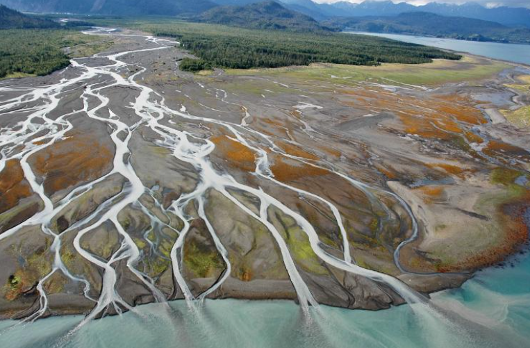
Delta Estuary
A delta estuary forms where a river deposits large quantities of sediment as it enters the sea, creating a complex network of distributary channels, islands, and wetlands that the river’s flow divides into as it approaches the coast. Delta estuaries are characterized by extremely flat topography and a constantly shifting pattern of channels and sediment deposits.
The sediment supply that creates a delta estuary also makes these systems particularly dynamic, with channels migrating, islands forming and eroding, and the overall shape of the delta changing over both short and long timescales. Major delta estuaries, including those of the Mississippi, the Ganges-Brahmaputra, and the Mekong, support some of the largest concentrations of wetland habitat and human population found anywhere along the world’s coastlines.
Coastal Lagoon
A coastal lagoon is a shallow body of water separated from the open ocean by a barrier of sand, coral, or other material, with limited exchange of water with the sea typically occurring through one or more narrow inlets. While similar to bar-built estuaries, coastal lagoons may receive relatively little freshwater input compared to other estuary types, sometimes resulting in salinity close to that of the open ocean.
The limited water exchange characteristic of coastal lagoons can result in longer residence times for water within the lagoon, meaning that nutrients, pollutants, and other substances may accumulate or be processed within the lagoon for extended periods before being flushed out to the open ocean. Coastal lagoons are found along many of the world’s coastlines and often support extensive seagrass beds and associated fisheries.