Ocean currents are continuous, directed movements of seawater that circulate through the world’s oceans, driven by a combination of wind, water density differences, tides, and the rotation of the Earth. These currents form an interconnected global circulation system often referred to as the ocean conveyor belt, transporting heat, nutrients, salt, dissolved gases, and marine organisms across vast distances and playing a fundamental role in regulating Earth’s climate. Without this constant redistribution of energy from the equator toward the poles, the temperature differences between different regions of the planet would be far more extreme than they currently are.
The forces that generate ocean currents operate at vastly different scales, from the wind-driven surface currents that respond to atmospheric patterns within days, to the deep, slow-moving currents driven by density differences that can take centuries to complete a single circuit of the global ocean. The Coriolis effect, caused by Earth’s rotation, deflects moving water to the right in the Northern Hemisphere and to the left in the Southern Hemisphere, creating the large rotating current systems known as gyres that dominate ocean circulation in each major ocean basin.
The climatic significance of ocean currents is difficult to overstate. The Gulf Stream alone transports heat northward through the Atlantic at a rate that has been compared to the output of millions of power stations, moderating temperatures across Western Europe and making regions at latitudes that would otherwise be quite cold considerably milder. Disruptions to major current systems, whether through natural variability or climate change, carry the potential for significant shifts in regional and global climate patterns, making the study of ocean currents a critical component of climate science.
Ocean currents can be classified along several dimensions — by the forces that drive them, by their depth in the water column, by their temperature relative to surrounding water, and by their geographic scale and location. Understanding the different types of currents reveals the complex, interconnected nature of global ocean circulation and the many ways that the movement of water shapes marine ecosystems, weather patterns, and the broader climate system that all life on Earth depends upon.
Surface Currents
Surface currents are wind-driven movements of water that occur in the upper layer of the ocean, typically extending to depths of around 400 meters, and are primarily generated by the friction between persistent wind patterns and the ocean’s surface. These currents respond relatively quickly to changes in wind patterns and are responsible for much of the large-scale horizontal movement of water observed in satellite imagery and navigational charts.
Surface currents play a crucial role in distributing heat from the tropics toward the poles, directly influencing regional climates along the coastlines they pass. They also transport nutrients, plankton, and the larvae of countless marine species, making them fundamentally important to the distribution and connectivity of marine ecosystems across ocean basins.
Deep Currents
Deep currents, also called deep water currents, occur far below the ocean surface and are driven primarily by differences in water density caused by variations in temperature and salinity rather than by wind. Denser water — which is typically colder and saltier — sinks and flows along the ocean floor, while less dense water rises, creating a slow but continuous circulation that connects the deep ocean basins of the world.
These currents move much more slowly than surface currents, often taking hundreds to a thousand years to complete a full circuit of the global ocean, but they play an essential role in distributing oxygen, nutrients, and carbon throughout the deep ocean. Deep currents are a critical component of the broader thermohaline circulation system that links surface and deep ocean processes into a single global circulation.
Thermohaline Circulation
Thermohaline circulation refers to the global system of ocean circulation driven by differences in water density, which are determined by temperature (thermo) and salinity (haline) variations across the world’s oceans. This circulation pattern connects surface currents in one part of the world to deep currents elsewhere, forming a continuous loop often visualized as a great ocean conveyor belt that links every major ocean basin.
The thermohaline circulation plays an outsized role in global climate regulation, redistributing heat absorbed in tropical regions toward the poles and bringing cold, nutrient-rich deep water back toward the surface in other regions. Scientists closely monitor this circulation system because of concerns that melting ice and changing precipitation patterns associated with climate change could weaken or disrupt this critical component of global ocean and climate dynamics.
Wind-Driven Currents
Wind-driven currents are surface currents generated directly by the friction of prevailing winds blowing across the ocean surface, transferring momentum from the atmosphere into the water and setting it into motion. The strength and direction of these currents closely correlate with the major global wind belts, including the trade winds near the equator and the westerlies at higher latitudes.
As wind-driven currents move, the Coriolis effect causes them to be deflected from the direction of the wind itself, creating spiraling patterns of water movement that decrease in speed and change in direction with increasing depth, a phenomenon known as the Ekman spiral. This deflection is fundamental to understanding why surface currents often flow at angles to the winds that generate them rather than directly in the wind’s own direction.
Tidal Currents
Tidal currents are the horizontal movements of water that accompany the rise and fall of tides, flowing toward shore during the flood tide and away from shore during the ebb tide. Unlike most other ocean currents, tidal currents reverse direction periodically in a predictable pattern that follows the same astronomical cycles that govern the tides themselves.
Tidal currents are typically strongest in narrow channels, straits, and estuaries where the volume of water moving with the tide is constrained into a smaller cross-sectional area, sometimes creating currents powerful enough to be harnessed for renewable energy generation. In some locations, tidal currents are strong enough to create dramatic phenomena such as tidal bores and significant navigational hazards for vessels.
Geostrophic Currents
A geostrophic current occurs when the pressure gradient force, created by differences in sea surface height or density, is balanced by the Coriolis effect, resulting in water flowing parallel to lines of equal pressure rather than directly down the pressure gradient. This balance is responsible for many of the large, persistent current systems found in the open ocean, including the major boundary currents of each ocean basin.
Geostrophic currents tend to be relatively stable and long-lived compared to more transient current patterns, as the balance of forces that creates them persists as long as the underlying pressure gradients and Coriolis effect remain in equilibrium. Understanding geostrophic balance is fundamental to oceanographers’ ability to calculate current speeds and directions from measurements of sea surface height and water density.
Gyres
A gyre is a large system of rotating ocean currents, formed primarily by global wind patterns and the Coriolis effect, that creates a roughly circular pattern of circulation within an ocean basin. There are five major gyres in the world’s oceans — the North Pacific, South Pacific, North Atlantic, South Atlantic, and Indian Ocean gyres — each rotating clockwise in the Northern Hemisphere and counterclockwise in the Southern Hemisphere.
Gyres play a significant role in distributing heat and nutrients across ocean basins, but they have also become infamous for accumulating floating marine debris, as the converging currents at the center of each gyre tend to concentrate plastic waste and other pollutants into massive accumulation zones. The Great Pacific Garbage Patch, located within the North Pacific Gyre, is the most well-known example of this concentrating effect.
Boundary Currents
A boundary current is a current that flows along the edge of an ocean basin, typically running parallel to a continental coastline, and forms as part of the larger gyre circulation system within that basin. Boundary currents are categorized as either western boundary currents, which flow along the western edges of ocean basins, or eastern boundary currents, which flow along the eastern edges.
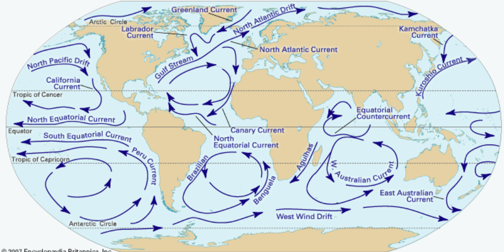
Western boundary currents, such as the Gulf Stream and the Kuroshio Current, are typically narrow, fast, and deep, carrying warm water from the tropics toward higher latitudes. Eastern boundary currents, by contrast, are typically broader, slower, and shallower, often carrying cooler water from higher latitudes toward the equator and frequently associated with significant upwelling of nutrient-rich deep water.
Western Boundary Currents
A western boundary current flows along the western edge of an ocean basin, carrying warm water poleward from tropical regions and forming the strongest and fastest currents found in the world’s oceans. The Gulf Stream in the Atlantic and the Kuroshio Current in the Pacific are the most prominent examples, both transporting enormous volumes of warm water toward higher latitudes.
These currents are intensified by a phenomenon known as western intensification, in which the Coriolis effect causes ocean currents to be compressed and accelerated along the western edges of ocean basins compared to the eastern edges. The warmth these currents carry has profound effects on the climates of the coastal regions they pass, often making them significantly milder than other locations at similar latitudes.
Eastern Boundary Currents
An eastern boundary current flows along the eastern edge of an ocean basin, typically carrying cooler water from higher latitudes toward the equator at relatively slow speeds across a broad area. The California Current in the Pacific and the Canary Current in the Atlantic are notable examples of this current type, both flowing along the eastern margins of their respective ocean basins.
Eastern boundary currents are frequently associated with coastal upwelling, in which winds push surface water away from the coast, allowing colder, nutrient-rich water from depth to rise and replace it. This upwelling makes the regions associated with eastern boundary currents among the most productive fishing grounds in the world, supporting major commercial fisheries.
Equatorial Currents
Equatorial currents are surface currents that flow along the equator, driven primarily by the trade winds that blow consistently from east to west in the tropics. The North and South Equatorial Currents flow westward across each ocean basin, while between them the Equatorial Countercurrent flows eastward, creating a complex system of currents flowing in opposing directions within a relatively narrow band near the equator.
These currents play an important role in redistributing heat within the tropics and influence weather patterns including the El Niño and La Niña phenomena, which involve significant shifts in the strength and position of Pacific equatorial currents. Changes in equatorial current patterns can have far-reaching effects on global weather, influencing rainfall patterns and temperatures across multiple continents.
Longshore Currents
A longshore current is a current that flows parallel to the shoreline within the surf zone, generated by waves approaching the beach at an angle and breaking in a way that creates a net flow of water along the coast. These currents are typically confined to a relatively narrow band close to shore and can vary significantly in strength depending on wave conditions.
Longshore currents are responsible for transporting sand and sediment along coastlines, a process known as longshore drift, which shapes beach profiles, creates and erodes sandbars, and influences the placement of coastal structures such as jetties and groins designed to manage sediment movement. Understanding longshore currents is essential for coastal engineering and beach management.
Rip Currents
A rip current is a narrow, fast-moving current that flows away from the shore, typically forming when water that has been pushed toward the beach by waves finds a path of least resistance back out to sea, often through a gap in a sandbar or near structures like piers. Rip currents can flow at speeds exceeding those of an Olympic swimmer, making them one of the most significant hazards to swimmers at surf beaches.
Unlike longshore currents, which move parallel to the beach, rip currents move perpendicular to the shoreline, carrying swimmers away from the beach rather than along it. Beach safety education emphasizes recognizing rip currents and, if caught in one, swimming parallel to the shore to escape the current’s pull rather than attempting to swim directly against it back to the beach.
Upwelling Currents
An upwelling current is a vertical movement of water in which cold, nutrient-rich water from the deep ocean rises to replace surface water that has been displaced, typically by wind patterns that push surface water away from a coastline or that diverge in the open ocean. Upwelling brings nutrients from the deep ocean into the sunlit surface layer where phytoplankton can use them for photosynthesis.
The enhanced productivity created by upwelling makes these regions among the most important fishing grounds in the world, supporting massive populations of fish, seabirds, and marine mammals that depend on the abundant phytoplankton and the zooplankton and fish that feed on it. Major upwelling zones occur along the coasts of Peru, California, and northwest Africa, among other locations.
Downwelling Currents
A downwelling current is a vertical movement of water in which surface water sinks toward the deep ocean, typically occurring where surface water becomes denser due to cooling or increased salinity, or where wind patterns cause surface water to converge and pile up before sinking. Downwelling is essentially the opposite process to upwelling, moving water and its dissolved properties from the surface toward depth.
Downwelling plays a critical role in transporting oxygen from the atmosphere and surface ocean into the deep ocean, where it is essential for the deep-sea organisms that depend on dissolved oxygen for respiration. Major downwelling regions, particularly in the polar oceans, are key components of the broader thermohaline circulation system that connects surface and deep ocean processes.
Coastal Currents
Coastal currents are currents that flow relatively close to shorelines, influenced by a combination of factors including local winds, river discharge, tides, and the broader current systems of the adjacent ocean basin. These currents can be highly variable, changing direction and strength over relatively short timescales in response to local weather conditions and freshwater inputs.
Coastal currents are particularly important for the dispersal of larvae and nutrients along coastlines, influencing the connectivity between different coastal habitats and the recruitment of marine species into coastal ecosystems. They also play a significant role in the transport of pollutants, sediment, and freshwater discharge from rivers along coastal margins.
Density Currents
A density current is any current driven by differences in water density, which can result from variations in temperature, salinity, or the concentration of suspended sediment, causing denser water to sink and flow beneath less dense water. Density currents occur at many scales, from small-scale flows in estuaries where freshwater meets saltwater to massive currents that drive the global thermohaline circulation.
These currents are particularly important in estuaries and fjords, where freshwater from rivers meets denser seawater, creating layered circulation patterns that influence the mixing and exchange of water, nutrients, and pollutants between these systems and the open ocean. Density currents driven by sediment concentration, known as turbidity currents, can also occur on continental slopes, where they play a role in transporting sediment to deep ocean basins.
Contour Currents
A contour current, also known as a contourite-forming current, is a deep ocean current that flows along the contours of the continental slope or seafloor topography, generally parallel to depth contours rather than flowing directly down or up a slope. These currents are typically associated with the deep, slow-moving water masses involved in thermohaline circulation.
Contour currents play a significant role in shaping deep-sea sediment deposits, creating distinctive sedimentary features called contourites that record information about past ocean circulation patterns. Geologists study these deposits to reconstruct how deep ocean circulation has changed over geological timescales, providing insights into past climate conditions.
Jet Streams (Oceanic)
An oceanic jet stream, sometimes called a current jet, is a narrow, fast-flowing band of water within a larger current system, analogous in concept to the atmospheric jet streams that influence weather patterns. These oceanic jets can occur within major boundary currents, where the current’s flow becomes concentrated into a particularly narrow and intense core.
Oceanic jet streams can have significant effects on the transport of heat, nutrients, and marine organisms, creating sharp boundaries between different water masses that influence the distribution of marine life. Understanding the position and strength of these jets is important for fisheries, as they often mark productive boundaries where different water masses meet and mix.