Mountains are among the most dramatic and awe-inspiring features on the surface of the Earth. Rising thousands of meters above the surrounding landscape, they shape weather patterns, define national borders, shelter unique ecosystems, and have served as landmarks, spiritual sites, and sources of wonder for human civilizations throughout history. From the frozen peaks of the Himalayas to the ancient, weathered ridges of the Appalachians and the fire-born summits of the Cascades, mountains come in a remarkable variety of forms, each shaped by different geological forces operating over vastly different timescales.
The study of mountains — their formation, structure, and distribution — falls within the field of orography, a branch of physical geography concerned with the measurement and description of mountains and their influence on the surrounding environment. Mountains cover approximately 27 percent of the Earth’s land surface and are home to roughly 15 percent of the global human population. They serve as the source of most of the world’s major rivers, feeding billions of people with freshwater drawn from snowmelt and glacial runoff. Mountain ecosystems are among the most biodiverse on the planet, harboring thousands of species of plants and animals found nowhere else on Earth.
Mountains are formed through a variety of geological processes, and it is these processes that largely determine their shape, height, and character. Some mountains are pushed up by the collision of tectonic plates, others are carved from ancient plateaus by erosion, and still others are built from the inside out by volcanic activity. The age of a mountain range is often visible in its profile — young mountains tend to be sharp, jagged, and towering, while ancient ranges worn down by millions of years of wind, rain, and ice present gentler, more rounded silhouettes. Understanding the different types of mountains is therefore not merely a matter of classification but a window into the deep geological history of our planet.
Fold Mountains
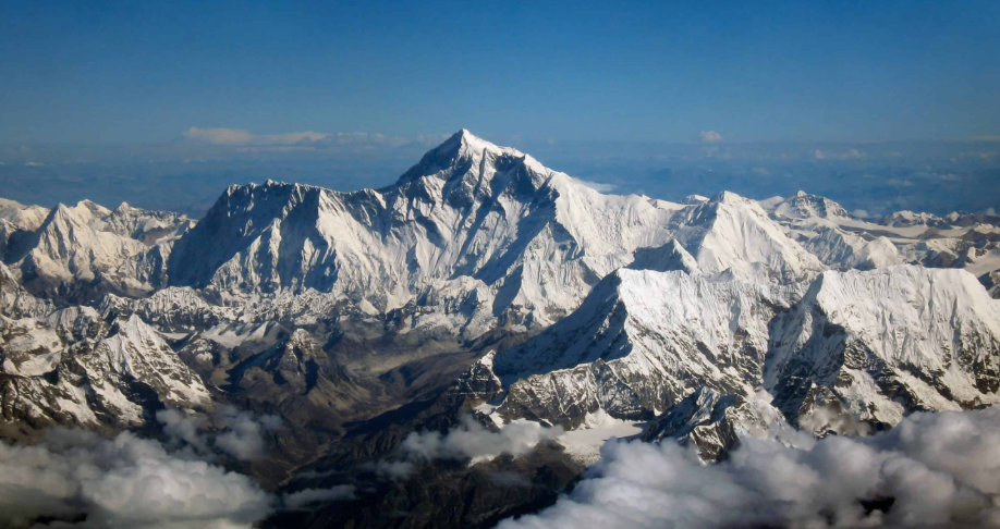
Fold mountains are the most common and widespread type of mountain on Earth, formed when two tectonic plates collide and the immense compressional forces cause the rock layers between them to buckle, wrinkle, and fold upward like a crumpled tablecloth. They are typically found along convergent plate boundaries where oceanic plates subduct beneath continental ones, or where two continental plates press directly against each other. The Himalayas, the Alps, the Andes, the Rockies, and the Appalachians are all fold mountain ranges. Fold mountains tend to be long, linear ranges stretching for hundreds or thousands of kilometers, and the youngest examples — like the Himalayas — are still actively rising as the Indian and Eurasian plates continue to converge.
Fault-Block Mountains
Fault-block mountains, also known as block mountains, are formed when large sections of the Earth’s crust are displaced along fault lines — fractures in the crust where rock masses move relative to one another. When tensional forces pull the crust apart, some blocks are thrust upward while adjacent blocks drop down, creating mountains with one steep, dramatic face along the fault scarp and a more gradual slope on the opposite side. The Sierra Nevada in California, the Tetons in Wyoming, and the Harz Mountains of Germany are classic examples of fault-block mountain ranges. The flat, elevated tops of many fault-block mountains reflect their origin as sections of crust that were lifted largely intact rather than folded or deformed.
Volcanic Mountains
Volcanic mountains are built from the inside out, formed by the accumulation of magma, lava, ash, and other volcanic materials erupted from vents in the Earth’s crust over repeated eruptions spanning thousands to millions of years. They are found along tectonic plate boundaries and above mantle hotspots, and they come in a variety of forms depending on the type and viscosity of the magma involved. Mount Fuji in Japan, Mount Kilimanjaro in Tanzania, and Mount Rainier in Washington State are iconic examples of volcanic mountains. Unlike fold or fault-block mountains that are shaped primarily by forces acting on pre-existing rock, volcanic mountains are constructive features, growing taller with each successive eruption.
Dome Mountains
Dome mountains form when magma pushes up from below and causes the overlying rock layers to bulge upward into a rounded, dome-like shape without actually erupting to the surface. Over time, erosion strips away the outer rock layers, exposing the harder igneous rock at the core and leaving behind a broadly rounded mountain mass. The Black Hills of South Dakota, the Adirondacks of New York, and the Ozark Mountains of Missouri and Arkansas are examples of dome mountain structures. Dome mountains tend to have relatively gentle slopes and rounded profiles compared to the sharp ridges of fold mountains or the steep faces of fault-block ranges.
Plateau Mountains
Plateau mountains are not formed by the upward movement of rock but by the erosion of an existing high plateau. When rivers, glaciers, and other erosional forces cut deeply into a plateau over millions of years, the remaining elevated sections between the eroded valleys stand as mountains. They are sometimes called erosion mountains for this reason. The Catskill Mountains of New York are a well-known example of plateau mountains, carved from an ancient flat-lying plateau by the persistent action of streams and rivers. Because they originate from flat surfaces, plateau mountains often retain relatively flat or gently rolling summits even as their sides are deeply dissected by erosion.
Residual Mountains
Residual mountains, also called relict mountains or mountains of circumdenudation, are the eroded remnants of ancient, once-much-larger mountain systems that have been worn down over immense periods of geological time. They represent what is left after millions of years of weathering and erosion have stripped away the bulk of an ancient range, leaving behind only the most resistant rock masses. The mountains of Scotland, the Scandinavian highlands, and many ranges in central Africa and Australia fall into this category. Residual mountains are typically low, rounded, and ancient, offering a striking contrast to the sharp, youthful peaks of tectonically active ranges.
Horst Mountains
A horst is an elevated block of the Earth’s crust that has been uplifted between two parallel fault lines while the adjacent blocks have dropped down or remained at lower elevations. The result is a raised, flat-topped or gently rounded mountain mass flanked on both sides by lower terrain — a kind of elevated crustal island. Horst mountains are closely related to fault-block mountains and are particularly common in regions of crustal extension where the Earth’s crust is being stretched and thinned. The Vosges Mountains in France and the Black Forest in Germany are classic horst structures, rising between the subsided Rhine Rift Valley on either side.
Graben Mountains
A graben is in many ways the opposite of a horst — a block of crust that has dropped down between two fault lines while the surrounding terrain remains elevated or is uplifted. While grabens themselves are lowlands or rift valleys rather than mountains, the elevated blocks on either side of a graben form what are effectively mountains by contrast. The East African Rift Valley is the world’s most dramatic example of graben formation, flanked by elevated highlands and associated volcanic peaks. The interplay between grabens and horsts across a landscape creates the alternating ridge-and-valley topography characteristic of many rift zones.
Monadnocks
A monadnock is an isolated hill or mountain of resistant rock that rises abruptly from a surrounding plain or gently rolling landscape, having survived the erosion that has worn down the surrounding terrain. The term comes from Mount Monadnock in New Hampshire, one of the most climbed mountains in the world. Monadnocks are composed of rock that is harder and more resistant to weathering than the surrounding material, allowing them to endure long after the landscape around them has been leveled. Inselbergs — isolated rocky hills rising from flat African plains — are a tropical variant of the monadnock, with Uluru in Australia being one of the world’s most famous examples.
Inselbergs
Inselbergs, from the German for “island mountains,” are isolated rocky hills or outcrops that rise steeply and dramatically from broad, flat surrounding plains, typically in arid or semi-arid tropical regions. They are formed when the surrounding rock weathers and erodes at a much faster rate than the resistant core of the inselberg, leaving it standing in stark isolation. Uluru and Kata Tjuta in Australia, the Brandberg in Namibia, and the various granite domes rising from the savanna plains of East Africa are all inselbergs. They are often of great cultural and spiritual significance to the indigenous peoples who have lived near them for thousands of years.
Buttes
Buttes are isolated, steep-sided, flat-topped hills formed by the erosion of a plateau or mesa, with a resistant cap rock protecting the underlying softer material from erosion. They are narrower than mesas — a guideline often used is that a butte’s height exceeds its top width — and they tend to stand alone or in small groups on otherwise open plains. Buttes are most strongly associated with the American Southwest, where the iconic red-rock buttes of Monument Valley in Arizona and Utah have become some of the most recognized and photographed landscapes in the world. Their dramatic, tower-like profiles make them among the most visually striking of all erosional landforms.
Mesas
Mesas are flat-topped, steep-sided elevated landforms wider than buttes, formed when a resistant cap rock protects the underlying softer rock from erosion while the surrounding terrain is worn away. The word “mesa” comes from the Spanish for “table,” and their broad, flat summits give them a distinctly table-like appearance. Mesas are common in arid and semi-arid regions where differential erosion operates most effectively, and they are particularly prominent in the Colorado Plateau region of the southwestern United States. As erosion continues over time, mesas gradually narrow and are eventually reduced to buttes, and ultimately to spires and isolated pillars of rock.
Hilly Mountains
Not all mountains rise to dramatic heights or sharp peaks — many mountain regions consist of gentler, rounded hills and ridges that nonetheless qualify as mountainous terrain by virtue of their elevation and topographic relief. These hilly mountains, sometimes classified simply as hill ranges, form through the same broad processes as larger mountains but represent either less intense tectonic activity, greater erosional modification over time, or both. The Scottish Highlands, the hills of the English Lake District, and many of the ancient ranges of central India and Africa present this character — landscapes of broad, sweeping uplands rather than soaring individual peaks.
Submarine Mountains (Seamounts)
Seamounts are mountains that rise from the ocean floor but do not reach the surface of the water, remaining entirely submerged. They are almost entirely volcanic in origin, formed by magma erupting through the oceanic crust at hotspots or along mid-ocean ridges. Seamounts are far more numerous than land-based mountains, with estimates suggesting there are over 100,000 of them in the world’s oceans. They are important features of the marine environment, creating upwellings of nutrient-rich water and serving as biodiversity hotspots in otherwise relatively barren stretches of the deep ocean. When a seamount grows tall enough to breach the ocean surface, it becomes a volcanic island.
Table Mountains
Table mountains are elevated landforms characterized by a distinctively flat, horizontal summit and steep, cliff-like sides. They are formed when resistant horizontal rock layers cap an elevated structure and protect the underlying rock from erosion, while the sides are carved away by weathering and erosion over millions of years. The most famous example is Table Mountain in Cape Town, South Africa, which rises dramatically above the city to a broad, flat summit frequently draped in a distinctive cloud formation known as the “tablecloth.” Tepuis — the ancient, flat-topped mountains of the Venezuelan and Guyanese highlands — are another spectacular example, their sheer sandstone walls and isolated summits harboring unique ecosystems found nowhere else on Earth.
Tepuis
Tepuis are ancient, flat-topped sandstone mountains found in the Guiana Highlands of South America, particularly in Venezuela, Guyana, and Brazil. They are among the oldest geological formations on Earth, their surfaces representing remnants of a vast plateau that has been deeply eroded over hundreds of millions of years. The isolation of tepui summits has allowed unique ecosystems to develop there, with a high proportion of plant and animal species found nowhere else on the planet. Angel Falls — the world’s highest uninterrupted waterfall — plunges from the edge of Auyán-tepui in Venezuela. Tepuis have long inspired the imagination of explorers and scientists, and Arthur Conan Doyle’s novel The Lost World was partly inspired by accounts of these mysterious, cloud-shrouded summits.
Horned Mountains (Arêtes and Horns)
Glacial erosion can sculpt existing mountains into dramatically sharp and angular forms quite different from their original shape. When glaciers carve into a mountain from multiple sides simultaneously, they create a pyramidal peak known as a glacial horn, with knife-edged ridges called arêtes radiating outward from the summit. The Matterhorn on the Swiss-Italian border is the world’s most iconic glacial horn, its near-perfect pyramidal shape the product of glaciers attacking the mountain from four directions. Arêtes — the sharp, narrow ridges connecting glacial peaks — create dramatic serrated skylines that characterize high alpine landscapes across the Alps, the Rockies, and the Himalayas.
Rift Mountains
Rift mountains form along divergent plate boundaries where the Earth’s crust is being pulled apart, creating a rift valley flanked by uplifted shoulders of elevated terrain. As the crust stretches and thins, the sides of the rift are uplifted by isostatic rebound and volcanic activity, forming elongated mountain ranges running parallel to the rift axis. The Ethiopian Highlands and the mountains flanking the East African Rift Valley are prime examples of rift mountains, as are the elevated terrains on either side of the Red Sea. Rift mountains are often associated with significant volcanic activity, since the thinning crust allows magma to rise more easily toward the surface.
Antipodal Mountains
Antipodal mountains are a more theoretical concept in geomorphology, referring to elevated regions that may have formed in response to major impact events on the opposite side of the Earth — the antipodal point — where seismic energy converging from all directions could cause crustal uplift or disruption. While this mechanism remains a subject of scientific debate, it has been proposed as a contributing factor in the formation of certain elevated regions on Mars and the Moon, and it represents an intriguing dimension of how large-scale planetary events can shape surface topography across vast distances.
Laccolith Mountains
Laccolith mountains form when magma intrudes between rock layers and pushes the overlying strata upward into a dome shape without erupting to the surface, solidifying underground into a lens-shaped body of igneous rock. Over time, erosion strips away the overlying sedimentary layers, exposing the hard igneous core and leaving a rounded mountain mass. The Henry Mountains of Utah are one of the best-studied examples of laccolith mountains in the world, having been described by the geologist Grove Karl Gilbert in his landmark 1877 study that first defined the term laccolith. Many of the isolated mountain masses of the Colorado Plateau region share a similar laccolithic origin.
Dissected Mountains
Dissected mountains are formed when a previously elevated but relatively flat or undulating landscape — such as an ancient plateau or peneplain — is deeply cut by river valleys and stream erosion over millions of years, leaving the intervening ridges and summits standing as mountains. The process of dissection gradually transforms a broad upland into a rugged, complex mountain landscape without any significant tectonic uplift being required. The Appalachian Mountains in their present form reflect a long history of dissection, with ancient rocks exposed at the surface by erosion carving deeply into what was once a much more uniform elevated surface.
Klippen Mountains
Klippen are isolated remnants of thrust sheets — large masses of rock that have been pushed horizontally over great distances by tectonic compression and then partly eroded away, leaving behind detached outliers of rock resting on top of younger strata. These isolated masses can form distinctive elevated features in the landscape, apparently anomalous in their rock type and age relative to their surroundings. The Préalpes Romandes in Switzerland include classic klippen structures, and understanding them was crucial to the development of the theory of thrust tectonics in the late 19th and early 20th centuries.
Cuesta Mountains
A cuesta is an asymmetrical ridge with one gentle slope that follows the dip of the underlying rock layers and one steep slope cut across those layers. Cuestas form in regions of gently tilted sedimentary rock where differential erosion acts more quickly on softer layers, leaving resistant rock layers standing as elongated ridges with their characteristic lopsided profiles. The North and South Downs of England are classic cuesta landforms, as are portions of the Paris Basin in France. Cuestas are important features in agricultural and settlement geography because their varied slopes and rock exposures create diverse soil and drainage conditions within a relatively small area.
Strike-Slip Mountains
Strike-slip mountains form along transform fault boundaries where tectonic plates slide horizontally past one another rather than converging or diverging. Although the primary motion along transform faults is lateral, irregularities and bends in the fault trace create zones of compression or extension that can push rock upward into mountain ridges or pull it apart into basins. The Transverse Ranges of southern California, which include the San Gabriel and San Bernardino Mountains, are among the best examples of mountains generated by the compressional effects of the complex fault systems associated with the San Andreas Fault. These mountains trend in an east-west direction, strikingly at odds with the northwest-southeast orientation typical of most California ranges.
Fold-and-Thrust Belt Mountains
Fold-and-thrust belt mountains are a more specific and structurally complex category within the broader family of fold mountains, characterized by a combination of folding and faulting in which rock layers are both crumpled into folds and pushed forward along thrust faults, stacking rock sequences on top of one another like overlapping shingles. This process produces some of the most structurally complex and geologically rich mountain terrains on Earth. The Canadian Rockies, the Zagros Mountains of Iran and Iraq, and the Jura Mountains of Switzerland and France are classic fold-and-thrust belt ranges. They are particularly important economically because the structural traps created by their folded and faulted rock layers frequently concentrate oil and natural gas deposits.
Ice-Capped Mountains (Glaciated Peaks)
Ice-capped mountains are high-altitude peaks and ranges whose upper elevations are permanently covered by glaciers, ice fields, and snowpack, creating a distinctive cryospheric environment quite different from the lower slopes. The permanent ice cover reshapes these mountains continuously through glacial erosion, carving cirques, horns, arêtes, and U-shaped valleys while simultaneously depositing moraines and other glacial sediments at lower elevations. The Himalayas, the Andes, the Alps, and the mountains of Alaska and Patagonia all include extensive ice-capped peaks. These mountains serve as critical freshwater reservoirs for downstream populations, and the accelerating retreat of their glaciers in response to climate change is one of the most pressing environmental concerns of the present century.