Earth movements are the dynamic physical processes through which the solid earth — its crust, mantle, and tectonic plates — shifts, deforms, and reorganizes itself in response to the enormous internal forces generated by radioactive heat decay, gravitational pressure, and the residual thermal energy left over from the planet’s formation approximately 4.5 billion years ago. These movements operate across timescales ranging from the instantaneous violence of an earthquake rupture to the imperceptibly slow drift of tectonic plates moving at rates of 2 to 15 centimetres per year, yet all are expressions of the same fundamental reality — that the earth is a dynamic, thermally active planet whose surface is in continuous, if often imperceptible, motion. The study of earth movements sits at the heart of geology, geophysics, and physical geography, informing everything from earthquake hazard assessment and volcanic risk mapping to our understanding of how mountain ranges, ocean basins, and continental landmasses have evolved over billions of years of geological time.
The consequences of earth movements for human civilization are profound and far-reaching. Tectonic activity has shaped the distribution of mineral resources, petroleum deposits, and fertile soils that underpin the economic geography of the modern world, while the same processes generate the earthquakes, volcanic eruptions, tsunamis, and landslides that constitute some of the deadliest and most economically costly natural hazards humanity faces. The United States Geological Survey estimates that earthquakes alone cause an average of $6.1 billion in economic losses annually in the United States, while the 2011 Tōhoku earthquake and tsunami in Japan — triggering the Fukushima nuclear disaster — caused total economic damages exceeding $360 billion, making it the costliest natural disaster in recorded history.
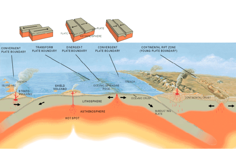
Scientific understanding of earth movements was transformed by the plate tectonics revolution of the 1960s, which unified previously disconnected observations about earthquakes, volcanoes, mountain building, and ocean floor topography into a single coherent theoretical framework explaining how the earth’s lithosphere is divided into approximately 15 major and numerous minor tectonic plates that interact at their boundaries through processes of subduction, collision, rifting, and lateral sliding. Before plate tectonics, earth movements were poorly understood and largely unexplained by any unified theory, but the acceptance of continental drift — first proposed by Alfred Wegener in 1912 and initially dismissed by the geological establishment — eventually led to the plate tectonics paradigm that now provides the foundational framework for all earth movement science. Today, GPS satellite networks can measure tectonic plate movements with millimetre precision, revolutionizing our ability to monitor, model, and ultimately better anticipate the earth movements that pose the greatest risks to human populations and infrastructure.
Tectonic Plate Movement
Tectonic plate movement is the most fundamental and far-reaching of all earth movements, describing the continuous horizontal displacement of the earth’s lithospheric plates — rigid slabs of crust and upper mantle averaging 100 kilometres in thickness — across the underlying asthenosphere, driven by convection currents in the mantle below. The approximately 15 major tectonic plates move at rates of 2 to 15 centimetres per year — roughly the speed at which human fingernails grow — yet over geological timescales these movements have assembled and dispersed entire supercontinents, opened and closed ocean basins, and fundamentally reorganized the geography of the planet multiple times. All other tectonic earth movements — earthquakes, volcanic eruptions, mountain building, and ocean floor spreading — are direct consequences of the interactions between moving plates at their boundaries.
Earthquakes
Earthquakes are sudden, rapid releases of energy stored in the earth’s crust as elastic strain, occurring when stress accumulated along fault planes or within tectonic plate interiors exceeds the frictional strength of the rock and rupture propagates along the fault surface at speeds of 2 to 4 kilometres per second, radiating seismic waves in all directions that shake the ground surface above. The global seismic network detects approximately 500,000 earthquakes per year worldwide, of which roughly 100,000 are strong enough to be felt by humans and approximately 100 cause significant damage or casualties. The 1960 Valdivia earthquake in Chile — the most powerful ever recorded at magnitude 9.5 — released more energy than all earthquakes recorded in the subsequent decade combined, illustrating the logarithmic scale of seismic energy release that makes great earthquakes so catastrophically destructive.
Volcanic Activity
Volcanic earth movements occur when molten rock — magma — generated by partial melting of the mantle or lower crust forces its way upward through the overlying lithosphere and erupts at the surface as lava, pyroclastic material, volcanic gases, and ash clouds that can extend hundreds of kilometres downwind and remain in the stratosphere for years. There are approximately 1,500 potentially active volcanoes on earth’s land surface, with 50 to 70 erupting in any given year, concentrated along tectonic plate boundaries and above mantle hotspots. The 1815 eruption of Mount Tambora in Indonesia — the largest volcanic eruption in recorded history — injected sufficient sulfur dioxide into the stratosphere to reduce global temperatures by 0.4 to 0.7°C, causing the 1816 “Year Without a Summer” that produced crop failures and famine across the Northern Hemisphere.
Folding
Folding occurs when rock layers subjected to compressional tectonic forces — typically at convergent plate boundaries where two plates collide — deform plastically rather than fracturing, bending into wavelike structures of upward-arching anticlines and downward-bowing synclines that can extend for hundreds of kilometres across mountain belts. The Himalayan mountain range — formed by the ongoing collision between the Indian and Eurasian plates that began approximately 50 million years ago — contains some of the most spectacular examples of large-scale geological folding on earth’s surface. The rate and style of folding depend on rock type, temperature, confining pressure, and the speed of applied stress, with deeply buried rocks deforming more plastically than near-surface rocks that tend to fracture under the same stress conditions.
Faulting
Faulting is the brittle fracture and displacement of rock along planar or curved rupture surfaces — faults — in response to tectonic stresses that exceed the rock’s compressive or tensile strength, producing the permanent offset of rock units on either side of the fault plane that can range from millimetres in minor fractures to hundreds of kilometres in major plate boundary fault systems. The San Andreas Fault in California — a right-lateral strike-slip fault marking the boundary between the Pacific and North American plates — has accumulated approximately 315 kilometres of total horizontal displacement over the past 20 million years and poses one of the most significant earthquake hazards in North America. Faults are classified by their geometry and the relative motion of their walls into normal faults, reverse faults, thrust faults, and strike-slip faults, each associated with different tectonic stress regimes and characteristic earthquake rupture patterns.
Isostatic Adjustment
Isostatic adjustment describes the slow, vertical movement of the earth’s crust in response to changes in the load it carries — rising when weight is removed and subsiding when weight is added — as the lithosphere seeks gravitational equilibrium with the underlying viscous mantle below. The most dramatic modern example is post-glacial rebound — the ongoing uplift of Scandinavia, Canada, and other regions formerly covered by thick ice sheets during the last glacial maximum, which have been rising at rates of up to 10 millimetres per year since the ice melted approximately 10,000 years ago, as the mantle slowly flows back into equilibrium beneath the unloaded crust. Conversely, deltaic regions like the Mississippi Delta and the Ganges-Brahmaputra Delta are experiencing isostatic subsidence under the weight of accumulated sediment, compounding sea level rise impacts on their populations.
Seafloor Spreading
Seafloor spreading is the process by which new oceanic crust is continuously created at mid-ocean ridges — underwater mountain ranges stretching over 65,000 kilometres through all the world’s ocean basins — where upwelling mantle material solidifies as basalt and is pushed laterally away from the ridge axis as new material is added from below. The Mid-Atlantic Ridge is spreading at approximately 2.5 centimetres per year, meaning that the Atlantic Ocean is widening at roughly the rate of human fingernail growth, while the East Pacific Rise spreads at up to 15 centimetres per year — one of the fastest spreading centers on earth. Harry Hess’s discovery of seafloor spreading in the early 1960s was one of the pivotal breakthroughs that led to the acceptance of plate tectonics theory by providing the mechanism by which continents could move apart without requiring the implausible notion that continents plowed through oceanic crust.
Subduction
Subduction is the process by which one tectonic plate descends beneath another into the mantle at convergent plate boundaries, driven by the negative buoyancy of old, cold, dense oceanic lithosphere relative to the underlying mantle through which it sinks. The subducting slab descends at angles of 25 to 90 degrees into the mantle, where it is progressively heated, dehydrated, and eventually assimilated back into the mantle over timescales of millions to tens of millions of years, completing the geological cycle of oceanic crust creation and destruction. Subduction zones are the sites of the world’s largest earthquakes — including the 2004 Indian Ocean earthquake (magnitude 9.1) and the 2011 Tōhoku earthquake (magnitude 9.0) — and generate the volcanic arcs that produce some of the most explosive and dangerous volcanoes on earth.
Continental Collision
Continental collision occurs when two plates carrying continental crust converge and neither is dense enough to subduct beneath the other, causing the crust to buckle, thicken, and be thrust upward into massive mountain ranges that represent the most dramatic topographic expression of tectonic plate movement on the planet’s surface. The ongoing collision between India and Eurasia — continuing at approximately 5 centimetres per year — has produced the Himalayan range and Tibetan Plateau, where the crust has been thickened to nearly 70 kilometres — roughly double the normal continental crustal thickness — and elevated to form the highest and most extensive high-altitude plateau on earth. Continental collisions ultimately slow as the collision zone thickens and the driving forces of subduction diminish, eventually producing ancient, deeply eroded mountain roots like the Appalachians and Scottish Highlands that testify to Paleozoic collisions long since ceased.
Rift Valley Formation
Rift valley formation occurs at divergent plate boundaries on continental crust, where tensional forces pull the lithosphere apart, causing it to thin, fracture along parallel normal faults, and drop down between the bounding fault scarps to create elongated topographic depressions bounded by elevated rift shoulders. The East African Rift System — stretching approximately 6,000 kilometres from the Afar Triangle in Ethiopia southward through Kenya, Tanzania, and Mozambique — is the world’s most active continental rift, where the African plate is actively splitting into two separate plates along a process that will eventually, over tens of millions of years, open a new ocean basin between the separating continental fragments. Rift valleys are associated with volcanic activity, geothermal resources, and shallow earthquakes, and their floors accumulate thick sequences of sediment and volcanic material that preserve important records of climate, environmental, and evolutionary change.
Landslides
Landslides are gravity-driven mass movements of rock, soil, and debris down slopes, triggered by a range of destabilizing factors including earthquake shaking, volcanic activity, intense rainfall, rapid snowmelt, erosion of slope bases, and human modification of slopes through excavation or loading. They represent one of the most geographically widespread and economically damaging of all geomorphic earth movement processes, occurring on every continent and in every climate zone where slopes exist, causing an estimated 5,000 deaths and $10 billion in economic losses globally in an average year. The 1970 Huascarán debris avalanche in Peru — triggered by the Ancash earthquake — buried the town of Yungay under millions of tonnes of ice, rock, and debris, killing an estimated 20,000 people in one of the deadliest landslide events in recorded history.
Soil Creep
Soil creep is the imperceptibly slow, continuous downslope movement of soil and regolith under gravity, operating too slowly to be directly observed but cumulatively significant over years and decades as evidenced by the characteristic downslope bending of fence posts, utility poles, and tree trunks, and the gradual accumulation of soil against upslope sides of walls and terraces. Operating at rates of 1 to 10 millimetres per year on most slopes, soil creep is driven by the repeated expansion and contraction of soil particles during wetting-drying and freezing-thawing cycles that progressively displace particles downslope with each cycle. Despite its lack of drama compared to sudden mass movement events, soil creep is responsible for significant long-term transport of soil material downslope and contributes meaningfully to landscape denudation over geological timescales.
Subsidence
Land subsidence is the gradual sinking or downward settling of the ground surface due to natural geological processes or human-induced causes including groundwater extraction, oil and gas withdrawal, underground mining, drainage of organic soils, and loading of compressible sediments by heavy structures. Mexico City has subsided by up to 10 metres over the past century due to compaction of the ancient lake sediments on which it is built as groundwater has been extracted from the underlying aquifer system, causing widespread building damage, infrastructure disruption, and increasing flood risk across the metropolitan area of 22 million people. Jakarta, Bangkok, Houston, and the Sacramento-San Joaquin Delta in California face similarly serious subsidence challenges from groundwater extraction that are compounding the impacts of sea level rise on coastal and deltaic urban populations.
Uplift
Tectonic uplift is the vertical elevation of crustal rocks relative to a datum — typically sea level — driven by isostatic forces, tectonic compression, magmatic intrusion, or the thermal expansion of lithosphere above mantle plumes, creating the topographic relief that drives erosion, river incision, and sediment transport systems. The Colorado Plateau has been uplifted approximately 2 kilometres over the past 5 to 6 million years, providing the driving force for the Colorado River’s dramatic incision of the Grand Canyon — one of the most spectacular examples of the interplay between tectonic uplift and fluvial erosion in creating landscape. Differential uplift rates between adjacent crustal blocks are responsible for the tilted fault blocks, asymmetric mountain ranges, and stepped topography characteristic of extensional tectonic settings worldwide.
Tsunamis
Tsunamis are large ocean waves generated by sudden vertical displacement of the seafloor during submarine earthquakes, volcanic eruptions, or submarine landslides — earth movements that instantaneously transfer enormous energy to the overlying water column, generating long-wavelength waves that travel across ocean basins at speeds of up to 800 kilometres per hour before slowing, amplifying, and inundating coastlines with devastating force. The 2004 Indian Ocean tsunami — generated by a magnitude 9.1 earthquake off the coast of northern Sumatra — killed approximately 227,000 people across 14 countries, making it the deadliest tsunami in recorded history and one of the deadliest natural disasters of the twenty-first century. Pacific Tsunami Warning Center monitoring systems now detect tsunamigenic earthquakes within minutes and issue warnings to coastal populations with sufficient lead time for evacuation in most — though not all — scenarios.
Creep on Fault Zones
Fault creep is the slow, aseismic sliding along fault planes that accommodates tectonic stress through continuous gradual displacement rather than the episodic stick-slip rupture that generates earthquakes, allowing accumulated strain to be released steadily without producing the destructive ground shaking associated with large seismic events. The Hayward Fault in the San Francisco Bay Area exhibits notable fault creep at rates of up to 9 millimetres per year along portions of its trace, producing the characteristic offset of streets, curbs, and building foundations visible in cities like Fremont and Hayward that straddle the fault. Understanding the distribution of creeping versus locked fault segments is critical for earthquake hazard assessment, as locked segments accumulate elastic strain that is eventually released in potentially large earthquakes while creeping segments pose lower seismic risk.
Glacial Movement
Glacial movement encompasses the flow of ice masses — valley glaciers, ice sheets, and ice streams — downslope or outward from accumulation zones under the influence of gravity, through mechanisms of internal deformation of ice crystals and basal sliding over the underlying bedrock lubricated by meltwater at the glacier base. Alpine glaciers typically flow at rates of centimetres to metres per day, while outlet glaciers draining the Greenland and Antarctic ice sheets can surge at rates of tens of metres per day during episodes of accelerated flow. Glacial movement is one of the most powerful agents of landscape modification on earth, responsible for carving the U-shaped valleys, fjords, cirques, and polished bedrock surfaces that characterize formerly glaciated landscapes across the northern hemisphere and alpine regions worldwide.
Magma Intrusion
Magmatic intrusion is the movement of molten rock through the overlying crust without reaching the surface, emplacing bodies of magma — dikes, sills, laccoliths, and plutons — that deform, metamorphose, and sometimes uplift the surrounding country rock as they force their way upward through fractures and along rock boundaries. The gradual solidification of large magmatic intrusions — batholiths of granite that underlie mountain ranges including the Sierra Nevada and the Scottish Highlands — represents the plutonic foundation of continental crust construction, while the forceful intrusion of shallow magma bodies beneath volcanoes produces the ground deformation, seismicity, and gas emissions that precede and accompany volcanic eruptions and are monitored closely by volcanological observatories worldwide.
Erosion-Driven Mass Wasting
Mass wasting encompasses the full spectrum of gravity-driven downslope movement of earth materials — from slow creep to catastrophic debris avalanches — that collectively represent one of the most important mechanisms of landscape evolution and sediment transfer from highlands to lowland depositional environments. The trigger mechanisms for mass wasting events — including earthquake shaking, intense rainfall, rapid snowmelt, freeze-thaw cycles, and undercutting of slope bases by rivers or wave action — interact with pre-existing slope materials and geometry to determine whether failure occurs gradually or catastrophically and how far mobilized material travels from the source area. Climate change is increasing the frequency and magnitude of rainfall-triggered mass wasting events globally as precipitation intensity increases and permafrost degradation destabilizes high-latitude and high-altitude slopes that were previously frozen year-round.
Earth Flows
Earthflows are slow to moderately rapid downslope movements of saturated fine-grained soils and weathered rock that behave in a viscous, flow-like manner — intermediate between a landslide and a mudflow — typically occurring on moderately steep slopes underlain by clay-rich or weathered materials that lose strength when their water content increases during prolonged rainfall or snowmelt. They characteristically produce elongated, tongue-shaped lobes of displaced material with steep headscarps at their upper ends and lobate deposit margins at their lower ends, and can remain active for years or decades, moving intermittently in response to seasonal changes in soil water content. Earthflows are particularly common and damaging in the Apennine mountains of Italy, the Coast Ranges of California, and the hill country of New Zealand, where clay-rich weathered rocks on steep slopes provide ideal conditions for their development.
Rockfalls
Rockfalls are the free fall, bouncing, and rolling of individual rock fragments or masses detached from steep cliffs and rock faces by the mechanical action of frost wedging, thermal expansion and contraction, root growth, earthquake shaking, or the progressive failure of rock bridges and buttresses that maintain slope integrity. They are among the most rapid of all mass movement processes — individual boulders can reach velocities of 30 to 50 metres per second during free fall on high cliffs — and their impact energy at the base of cliffs makes them extremely dangerous to people, vehicles, and infrastructure in mountainous terrain. Rockfall hazard management — through rock face stabilization, catch fences, draped mesh systems, and rock sheds over roads and railways — represents a major engineering challenge and ongoing maintenance cost in mountain transportation infrastructure worldwide.
Seismic Ground Deformation
Seismic ground deformation encompasses the permanent changes in ground surface elevation, horizontal position, and topographic configuration that accompany large earthquakes, including surface rupture along fault traces, coseismic uplift and subsidence of crustal blocks, lateral spreading of saturated sediments, and the dramatic landscape changes produced by earthquake-triggered landslides and tsunamis. The 1964 Alaska earthquake (magnitude 9.2) produced coseismic uplift of up to 11.5 metres in some coastal areas and subsidence of up to 2.4 metres in others, permanently altering the coastal geography of southcentral Alaska across hundreds of kilometres. Modern GPS, InSAR satellite radar, and LiDAR technologies allow scientists to map coseismic ground deformation with centimetre-scale precision across entire earthquake rupture zones within days of major events, dramatically improving understanding of fault geometry and rupture mechanics.
Liquefaction
Liquefaction is the process by which saturated, loosely packed sandy or silty soils temporarily lose their shear strength and behave as a viscous liquid when subjected to the cyclic stress of earthquake shaking, causing the ground surface to settle, tilt, crack, and eject sand and water in dramatic sand boil fountains as the liquefied soil layer below loses its capacity to support the weight of overlying structures. The 2010 and 2011 Christchurch earthquakes in New Zealand produced some of the most extensively documented urban liquefaction in history, with large areas of residential Christchurch experiencing repeated liquefaction that deposited millions of tonnes of silt across streets, gardens, and properties and ultimately rendered entire suburbs uninhabitable. Liquefaction susceptibility mapping has become a standard component of urban planning and building code frameworks in seismically active cities worldwide.
Diapirism
Diapirism is the buoyancy-driven upward movement of low-density material — most commonly evaporite salt, but also mobile shales, serpentinite, and magma — through denser overlying rocks, creating dome-shaped intrusive bodies called diapirs that deform, pierce, and sometimes breach the overlying sedimentary sequence. Salt diapirs — formed by the upward flow of buried evaporite deposits under the weight of overlying sediments — create the salt domes that trap petroleum and natural gas in prolific oil fields across the Gulf of Mexico, the North Sea, the Middle East, and the Gulf of Guinea, making diapirism of direct economic importance to the hydrocarbon industry. The viscous flow of salt through overlying sedimentary sequences can continue for millions of years, producing complex three-dimensional structural geometries that require sophisticated seismic imaging to map and understand.
Thermal Convection in the Mantle
Mantle convection is the slow, thermally driven circulation of rock in the earth’s solid but ductile mantle — the 2,900-kilometre-thick layer between the crust and core — that is the ultimate driving force behind all tectonic plate movement and the surficial earth movements that result from it. Hot mantle rock near the core-mantle boundary is less dense than cooler rock above it, causing it to rise slowly in broad upwelling plumes while cooler, denser material near the top of the mantle sinks in downwelling sheets — creating a convective circulation that drags the overlying tectonic plates and drives their horizontal movement across the planet’s surface. Mantle convection operates at velocities of centimetres per year and timescales of hundreds of millions of years, yet it is the engine that has driven every mountain-building event, ocean opening, and continental reorganization in the 4.5-billion-year history of the earth.